Ternat
| Ternat | |||
|---|---|---|---|
| Municipality | |||
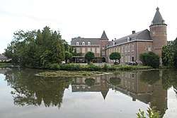 Kruikenburg Castle, Ternat | |||
| |||
 Ternat Location in Belgium
Location of Ternat in Flemish Brabant 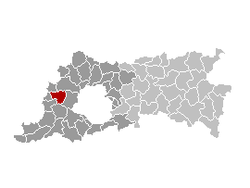 | |||
| Coordinates: 50°52′N 04°11′E / 50.867°N 4.183°ECoordinates: 50°52′N 04°11′E / 50.867°N 4.183°E | |||
| Country | Belgium | ||
| Community | Flemish Community | ||
| Region | Flemish Region | ||
| Province | Flemish Brabant | ||
| Arrondissement | Halle-Vilvoorde | ||
| Government | |||
| • Mayor | Ronald Parys (LVB) | ||
| • Governing party/ies | LVB | ||
| Area | |||
| • Total | 24.48 km2 (9.45 sq mi) | ||
| Population (1 January 2017)[1] | |||
| • Total | 15,428 | ||
| • Density | 630/km2 (1,600/sq mi) | ||
| Postal codes | 1740-1742 | ||
| Area codes | 02, 053 | ||
| Website | www.ternat.be | ||


Ternat (Dutch pronunciation: [tɛrˈnɑt]) is a municipality located in the Belgian province of Flemish Brabant. The municipality comprises the villages of Sint-Katherina-Lombeek, Ternat proper and Wambeek. On January 1, 2006 Ternat had a total population of 14,625. The total area is 24.48 km² which gives a population density of 597 inhabitants per km².
The village of Ternat is the site of a medieval sandstone church and the 12th-century Kruikenburg Castle, extensively remodelled in the 17th century.[2] The local authority offices are housed in an 18th-century mansion.[3]
Notable people
- Everard t'Serclaes (c.1320–1388)
References
- ↑ Population per municipality as of 1 January 2017 (XLS; 397 KB)
- ↑ Kasteel Kruikenburg, website Toerisme Vlaams Brabant, accessed 23 October 2015.
- ↑ Kasteel De Mot, Flemish Heritage Register. Accessed 23 October 2015.
External links

This article is issued from
Wikipedia.
The text is licensed under Creative Commons - Attribution - Sharealike.
Additional terms may apply for the media files.