Holsbeek
| Holsbeek | |||
|---|---|---|---|
| Municipality | |||
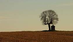 The chapel of Saint Joseph, near Sint-Pieters-Rode, Holsbeek | |||
| |||
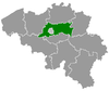
 Holsbeek Location in Belgium
Location of Holsbeek in Flemish Brabant 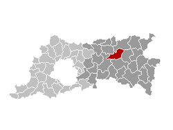 | |||
| Coordinates: 50°55′N 04°46′E / 50.917°N 4.767°ECoordinates: 50°55′N 04°46′E / 50.917°N 4.767°E | |||
| Country | Belgium | ||
| Community | Flemish Community | ||
| Region | Flemish Region | ||
| Province | Flemish Brabant | ||
| Arrondissement | Leuven | ||
| Government | |||
| • Mayor | Hans Eyssen (CD&V-CP) | ||
| • Governing party/ies | CD&V-CP, sp.a, NIEUW | ||
| Area | |||
| • Total | 38.50 km2 (14.86 sq mi) | ||
| Population (1 January 2017)[1] | |||
| • Total | 9,920 | ||
| • Density | 260/km2 (670/sq mi) | ||
| Postal codes | 3220, 3221 | ||
| Area codes | 016 | ||
| Website | www.holsbeek.be | ||

Holsbeek (Dutch pronunciation: [ˈɦɔlzbeːk]) is a municipality located in the Belgian province of Flemish Brabant. The municipality comprises the towns of Holsbeek proper, Kortrijk-Dutsel, Nieuwrode and Sint-Pieters-Rode. On January 1, 2006, Holsbeek had a total population of 9,205. The total area is 38.50 km² which gives a population density of 239 inhabitants per km².
The best known historical landmark of the municipality is the medieval castle of Horst.
References
- ↑ Population per municipality as of 1 January 2017 (XLS; 397 KB)
External links

- Gazetteer Entry
Places adjacent to Holsbeek | ||||||||||
|---|---|---|---|---|---|---|---|---|---|---|
| ||||||||||
This article is issued from
Wikipedia.
The text is licensed under Creative Commons - Attribution - Sharealike.
Additional terms may apply for the media files.