Haacht
| Haacht | |||
|---|---|---|---|
| Municipality | |||
 Tildonk | |||
| |||
 Haacht Location in Belgium
Location of Haacht in Flemish Brabant 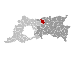 | |||
| Coordinates: 50°59′N 04°38′E / 50.983°N 4.633°ECoordinates: 50°59′N 04°38′E / 50.983°N 4.633°E | |||
| Country | Belgium | ||
| Community | Flemish Community | ||
| Region | Flemish Region | ||
| Province | Flemish Brabant | ||
| Arrondissement | Leuven | ||
| Government | |||
| • Mayor | Steven Swiggers (Open VLD) | ||
| • Governing party/ies | VLD, CD&V | ||
| Area | |||
| • Total | 30.57 km2 (11.80 sq mi) | ||
| Population (1 January 2017)[1] | |||
| • Total | 14,442 | ||
| • Density | 470/km2 (1,200/sq mi) | ||
| Postal codes | 3150 | ||
| Area codes | 016, 015 | ||
| Website | www.haacht.be | ||


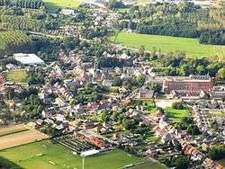
Haacht (Dutch pronunciation: [ɦaːxt]) is a municipality located in the Belgian province of Flemish Brabant. The municipality comprises the towns of Haacht proper, Kelfs, Tildonk, Wakkerzeel and Wespelaar.
On January 1, 2006, Haacht had a total population of 13,608. The total area is 30.57 km² which gives a population density of 445 inhabitants per km².
Attractions
Special attractions in Haacht are:
- The church St.-Remigius, of which some walls still date the original construction from the year 1281.
- The Anti-Tank canal, a defensive line built in 1939 to protect against German attack. It proved ineffective, as the invading Germans took a wide detour around it. In 1997 the nature preservation group Natuurpunt made it a protected natural area.
- The brewery of Haacht, the biggest Belgian brewery that is still in Belgian ownership and the third Belgian brewery regarding marketshare. The brewery is named after the municipality of Haacht but is actually located within the borders of neighbouring municipality Boortmeerbeek.
- The new sporting facilities 'Den Dijk', opened in 2003, with a separate gymnastics hall.
- It also has the nearest train station in its surroundings: Haacht Railway Station.
 Sint Remigius church
 Anti-Tank canal, built to protect against the German tank attacks during World War II, today a preserved natural area
References
- ↑ Population per municipality as of 1 January 2017 (XLS; 397 KB)
External links

- Official website - Only available in Dutch
- Haachtse Geschied- en Oudheidkundige Kring - Only available in Dutch
- Haacht Brewery
Places adjacent to Haacht | |
|---|---|
This article is issued from
Wikipedia.
The text is licensed under Creative Commons - Attribution - Sharealike.
Additional terms may apply for the media files.