Bekkevoort
| Bekkevoort | |||
|---|---|---|---|
| Municipality | |||
 | |||
| |||
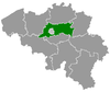
 Bekkevoort Location in Belgium
Location of Bekkevoort in Flemish Brabant  | |||
| Coordinates: 50°57′N 04°58′E / 50.950°N 4.967°ECoordinates: 50°57′N 04°58′E / 50.950°N 4.967°E | |||
| Country | Belgium | ||
| Community | Flemish Community | ||
| Region | Flemish Region | ||
| Province | Flemish Brabant | ||
| Arrondissement | Leuven | ||
| Government | |||
| • Mayor | Hans Vandenberg (CD&V) | ||
| • Governing party/ies | CD&V, sp.a | ||
| Area | |||
| • Total | 37.17 km2 (14.35 sq mi) | ||
| Population (1 January 2017)[1] | |||
| • Total | 6,134 | ||
| • Density | 170/km2 (430/sq mi) | ||
| Postal codes | 3460, 3461 | ||
| Area codes | 013, 016 | ||
| Website | www.bekkevoort.be | ||


Bekkevoort (Dutch pronunciation: [ˈbɛkəvoːrt]) is a municipality located in the Belgian province of Flemish Brabant. The municipality comprises the towns of Assent, Bekkevoort proper and Molenbeek-Wersbeek. On January 1, 2006, Bekkevoort had a total population of 5,826. The total area is 37.17 km² which gives a population density of 157 inhabitants per km².
It gains its name from the germanic name "Baco" and the word "voorde" (which means a place of ferriage, where one can easily cross a stream via a place where the waters are lower), thus roughly meaning "Baco's wade". This ferriage formed the historical center of the town and is nowadays known as the road Steenberg, from Bekkevoort to Zichem and Scherpenheuvel.
References
- ↑ Population per municipality as of 1 January 2017 (XLS; 397 KB)
External links

Places adjacent to Bekkevoort | ||||||||||
|---|---|---|---|---|---|---|---|---|---|---|
| ||||||||||
This article is issued from
Wikipedia.
The text is licensed under Creative Commons - Attribution - Sharealike.
Additional terms may apply for the media files.