Arrondissement of Leuven
| Administrative Arrondissement of Leuven Arrondissement Leuven | |
|---|---|
| Administrative Arrondissement | |
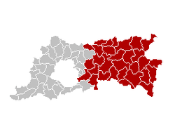 Location of the arrondissement in Flemish Brabant | |
| Coordinates: 50°54′N 4°48′E / 50.9°N 4.8°ECoordinates: 50°54′N 4°48′E / 50.9°N 4.8°E | |
| Country |
|
| Region |
|
| Province |
|
| Municipalities | 30 |
| Area | |
| • Total | 1,168.83 km2 (451.29 sq mi) |
| Population (1 January 2017) | |
| • Total | 502,602 |
| • Density | 430/km2 (1,100/sq mi) |
| Time zone | UTC+1 (CET) |
| • Summer (DST) | UTC+2 (CEST) |
The Leuven Arrondissement (Dutch: Arrondissement Leuven; French: Arrondissement de Louvain) is one of two arrondissements in the Belgian province of Flemish Brabant. It lies east of the Brussels-Capital Region. The arrondissement has an area of 1,168.83 km2 (451.29 sq mi) and has (as of January 1, 2017) 502,602 inhabitants.
Municipalities
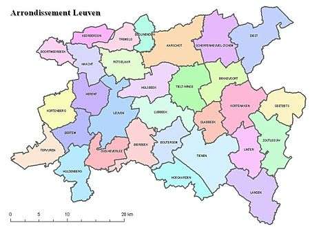
The arrondissement of Leuven
The arrondissement is made up of the following municipalities:
|
|
|
|
Formerly independent municipalities or deelgemeenten:
| Judicial area of Antwerp | |
|---|---|
| Judicial area of Brussels | |
| Judicial area of Ghent | |
| Judicial area of Liège | |
| Judicial area of Mons | |
This article is issued from
Wikipedia.
The text is licensed under Creative Commons - Attribution - Sharealike.
Additional terms may apply for the media files.