Bago, Myanmar
| Bago ပဲခူးမြို့ | |
|---|---|
| City | |
.JPG) | |
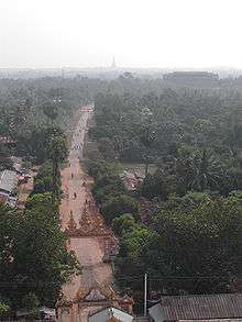
 Bago Location of Bago, Myanmar | |
| Coordinates: 17°20′12″N 96°28′47″E / 17.33667°N 96.47972°E | |
| Country |
|
| Division |
|
| Founded | 1152CE |
| Elevation | 13 ft (4 m) |
| Population (2012) | |
| • City | 491,434 |
| • Metro | 5,739,344 |
| • Ethnicities | Bamar, Shan, Burmese Chinese, Burmese Indians, Kayin |
| • Religions | Buddhism |
| Time zone | UTC+6.30 (MMT) |
Bago (formerly spelt Pegu;[1] Burmese: ပဲခူးမြို့; MLCTS: pai: khu: mrui., IPA: [bəɡó mjo̰]; Mon: ဗဂေါ, [həkɜ̀]), formerly known as Hanthawaddy (Burmese: ဟံသာဝတီ; Mon: ဟံသာဝတဳ Hongsawatoi; Pali: Haṃsāvatī; meaning "She Who Has Swans"), is a city and the capital of the Bago Region in Myanmar. It is located 91 kilometres (57 mi) north-east of Yangon.
History

Various Mon language chronicles report widely divergent foundation dates of Bago, ranging from 573 CE to 1152 CE[note 1] while the Zabu Kuncha, an early 15th century Burmese administrative treatise, states that Pegu was founded in 1276/77 CE.[2] The earliest extant evidence of Pegu as a place dates only to the late Pagan period (1212 and 1266)[note 2] when it was still a small town, not even a provincial capital. After the collapse of the Pagan Empire, Bago became part of the breakaway Kingdom of Martaban by the 1290s.
The small settlement grew increasingly important in the 14th century as the region became most populous in the Mon-speaking kingdom. In 1369, King Binnya U made Bago the capital. The city remained the capital until the kingdom's fall in 1538/39.
During the reign of King Razadarit, Bago and Ava Kingdom were engaged in the Forty Years' War. The peaceful reign of Queen Shin Sawbu came to an end when she chose the Buddhist monk Dhammazedi (1472–1492) to succeed her. Under Dhammazedi, Bago became a centre of commerce and Theravada Buddhism.
In 1519, António Correia, then a merchant from the Portuguese casados settlement at Cochin landed in Bago, then known to the Portuguese as Pegu, looking for new markets for pepper from Cochin.[3][4] A year later, Portuguese India Governor Diogo Lopes de Sequeira sent an ambassador to Pegu.
As a major seaport, the city was frequently visited by Europeans, among these, Gasparo Balbi in the late 1500s. The Europeans often commented on its magnificence.
The Portuguese conquest of Pegu, following the destruction caused by the kings of Tangot and Arrakan in 1599, was described by Manuel de Abreu Mousinho in "Breve discurso em que se conta a conquista do Reino do Pegú na India oriental feita pelos portugueses em tempo do vice-rei Aires de Saldanha, sendo capitão Salvador Ribeiro de Sousa, chamado Massinga, natural de Guimarães, a quem os naturais do Pegú elegeram por seu rei no ano de 1600" (Brief narrative telling the conquest of Pegu in eastern India made by the Portuguese in the time of the viceroy Aires de Saldanha, being captain Salvador Ribeiro de Sousa, called Massinga, born in Guimarães, elected as their king by the natives in the year 1600), published from 1711 to 1829 with "Peregrinaçam" of Fernão Mendes Pinto.
The capital was looted by the viceroy of Toungoo, Minye Thihathu II of Toungoo, and then burned by the viceroy of Arakin during the Burmese–Siamese War (1594–1605). Anaukpetlun wanted to rebuild Hongsawadi, which had been deserted since Nanda Bayin had abandoned it. He was only able to build a temporary palace, however.[5]:151–162,191
The Burmese capital relocated to Ava in 1634. In 1740, the Mon revolted and founded the Restored Hanthawaddy Kingdom. However, a Bamar king, Alaungpaya, captured the city in May 1757.
Bago was rebuilt by King Bodawpaya (r. 1782-1819), but by then the river had shifted course, cutting the city off from the sea. It never regained its previous importance. After the Second Anglo-Burmese War, the British annexed Bago in 1852. In 1862, the province of British Burma was formed, and the capital moved to Yangon. The substantial differences between the colloquial and literary pronunciations, as with Burmese words, was a reason of the British corruption "Pegu".
In 1911, Hanthawaddy was described as a district in the Bago (or Pegu) division of Lower Burma. It lay in the home district of Yangon, from which the town was detached to make a separate district in 1880. It had an area of 3,023 square miles (7,830 km2), with a population of 48,411 in 1901, showing an increase of 22% in the past decade. Hanthawaddy and Hinthada were the two most densely populated districts in the province.
Hanthawaddy, as it was constituted in 1911, consisted of a vast plain stretching up from the sea between the mouth of the Irrawaddy River and the Pegu Range. Except the tract of land lying between the Pegu Range on the east and the Yangon River, the country was intersected by numerous tidal creeks, many of which were navigable by large boats and some by steamers. The headquarters of the district was in Rangoon, which was also the sub-divisional headquarters. The second sub-division had its headquarters at Insein, where there were large railway works. Cultivation was almost wholly confined to rice, but there were many vegetable and fruit gardens.
Today, Hanthawaddy is one of the wards of Bago city.
Places of interest
- Shwethalyaung Buddha (Reclining Buddha)
- Shwemawdaw Pagoda
- Kyaikpun Buddha
- Kanbawzathadi Palace site and museum
- Kalyani Ordination Hall
- Mahazedi Pagoda
- Shwegugyi Pagoda
- Shwegugale Pagoda
- Bago Sittaung Canal
Sports
- Grand Royal Stadium
Health care
- Bago General Hospital
- Bago Traditional Medicine Hospital
Education
- Bago University
- Basic Education High School No. 1 Bago
Notes
- ↑ A version of the 18th century chronicle Slapat Rajawan as reported by Arthur Phayre (Phayre 1873: 32) states that the settlement was founded in 1116 Buddhist Era (572/573 CE). But another version of the Slapat, used by P.W. Schmidt (Schmidt 1906: 20, 101), states that it was founded on 1st waxing of Mak (Tabodwe) 1116 BE (c. 19 January 573 CE), which it says is equivalent to year 514 of "the third era", without specifying what the era specifically was. However, per (Phayre 1873: 39), one of the "native records" used by Maj. Lloyd says that Pegu was founded in 514 Burmese (Myanmar) Era (1152/1153 CE).
If the year 514 is indeed the Burmese Era, then the Slapat's 1st waxing of Tabodwe 514 would be 27 December 1152, equivalent to 1st waxing of Tabodwe 1696 BE (not 1116 BE). - ↑ (Aung-Thwin 2005: 59) cites the 1266 inscription. (SMK Vol. 3 1983: 28–31): The inscription at the Min-Nan-Thu village near Bagan donated by daughter of Theingathu, dated Thursday, 7th waxing of Nanka (Wagaung) 628 ME (8 July 1266), lists Pegu as Pe-Ku. (Aung-Thwin 2017: 200, 332) updates by saying that the earliest extant inscriptions that mention Pegu date to 1212 and 1266 but does not provide the source of the 1212 inscription. None of the inscriptions listed in the Ancient Burmese Stone Inscriptions (SMK Vol. 1 1972: 93–102) for years 573 ME (1211/1212) or 574 ME (1212/1213) shows Pe-Ku or Pegu.
References
- ↑

- ↑ Aung-Thwin 2017: 332
- ↑ Luís Filipe Tomás (1976). "A viagem de António Correia a Pegu em 1519" (PDF) (in Portuguese). Junta de Investigações do Ultramar, [Lisboa]. Retrieved 2014-08-05.
- ↑ Malekandathil, Pius M C (2010-10-26). "ORIGIN AND GROWTH OF LUSO-INDIAN COMMUNITY in Portuguese Cochin and the maritime trade of India, 1500-6663" (PDF). Pondicherry University. Retrieved 2014-08-05. |
- ↑ Rajanubhab, D., 2001, Our Wars With the Burmese, Bangkok: White Lotus Co. Ltd., ISBN 9747534584
Bibliography
- Aung-Thwin, Michael A. (2005). The Mists of Rāmañña: The Legend that was Lower Burma (illustrated ed.). Honolulu: University of Hawai'i Press. ISBN 9780824828868.
- Aung-Thwin, Michael A. (2017). Myanmar in the Fifteenth Century. Honolulu: University of Hawai'i Press. ISBN 978-0-8248-6783-6.
- Nyein Maung, ed. (1972–1998). Shay-haung Myanma Kyauksa-mya [Ancient Burmese Stone Inscriptions] (in Burmese). 1–5. Yangon: Archaeological Department.
- Pan Hla, Nai (1968). Razadarit Ayedawbon (in Burmese) (8th printing, 2005 ed.). Yangon: Armanthit Sarpay.
- Phayre, Major-General Sir Arthur P. (1873). "The History of Pegu". Journal of the Asiatic Society of Bengal. Calcutta. 42: 23–57, 120–159.
- Phayre, Lt. Gen. Sir Arthur P. (1883). History of Burma (1967 ed.). London: Susil Gupta.
- Schmidt, P.W. (1906). "Slapat des Ragawan der Königsgeschichte". Die äthiopischen Handschriften der K.K. Hofbibliothek zu Wien (in German). Vienna: Alfred Hölder. 151.
Further reading
| Wikimedia Commons has media related to Bago. |
Bago, Myanmar | ||
| Preceded by Donwun |
Capital of Hanthawaddy Kingdom 1369 – by 31 March 1539 |
Succeeded by End of Kingdom |
| Preceded by Toungoo |
Capital of Burma by 31 March 1539 – 30 April 1550 |
Succeeded by Ava |
| Preceded by Founded |
Capital of Hanthawaddy Kingdom June 1550 – 12 March 1552 |
Succeeded by End of Kingdom |
| Preceded by Toungoo |
Capital of Burma 12 March 1552 – 19 December 1599 |
Succeeded by Ava |
| Preceded by Ava |
Capital of Burma 14 May 1613 – 25 January 1635 |
Succeeded by Ava |
| Preceded by Founded |
Capital of Restored Hanthawaddy Kingdom November 1740 – 6 May 1757 |
Succeeded by End of Kingdom |
Capital: Bago | ||||||
| East Bago Region |
|   | ||||
| West Bago Region |
| |||||
| Main cities and towns | ||||||
| Wikivoyage has a travel guide for Bago (Myanmar). |