Sittaung River
| Sittaung River | |
|---|---|
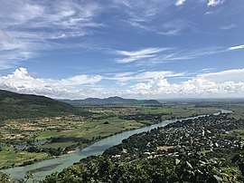 Sittaung River near Pyinmana | |
| Native name | စစ်တောင်းမြစ် |
| Country | Myanmar, Bago Division |
| Physical characteristics | |
| Main source | Shan Hills |
| River mouth |
Gulf of Moattama, Andaman Sea 0 m (0 ft) 16°57′54″N 96°59′15″E / 16.96500°N 96.98750°ECoordinates: 16°57′54″N 96°59′15″E / 16.96500°N 96.98750°E |
| Length | 420 kilometres (260 mi) |
| Discharge |
|
The Sittaung or, officially, Sittoung[1] River (Burmese: စစ်တောင်းမြစ် [sɪʔ táʊɴ mjɪʔ]; formerly, the Sittang), is a river in south central Myanmar in Bago Division. The Pegu Range separates its basin from that of the Irrawaddy. The river originates at the edge of the Shan Plateau southeast of Mandalay, and flows southward to the Gulf of Martaban. Its length is 420 km and its mean annual discharge is around 50 cubic kilometers per year.
Basin
Although it flows through fairly flat country, the Sittaung has a notorious tidal bore at its mouth which has precluded any but very small craft navigating the river. The river is navigable for 40 km year round and for 90 km during three months of the year.
The river is used primarily to float timber south for export.[2] Strong currents make the river even less valuable as a means of transport in eastern Burma. Its basin does not have the same richness for agriculture as the Irrawaddy because there is no soil flowing down from the Shan Hills.
See also
- Battle of Sittang Bridge in 1942
References
- ↑ https://unstats.un.org/unsd/geoinfo/UNGEGN/docs/8th-uncsgn-docs/inf/8th_UNCSGN_econf.94_INF.75.pdf
- ↑ "Sittaung River". Myanmar's Net. Archived from the original on 16 April 2009.
External links