1976 Tangshan earthquake
 | |
| UTC time | Doublet earthquake: |
|---|---|
| A: 1976-07-27 19:42:55 | |
| B: 1976-07-28 10:45:36 | |
| ISC event | |
| A: 711732 | |
| B: 711773 | |
| USGS-ANSS | |
| A: ComCat | |
| B: ComCat | |
| Local date | 28 July 1976 |
| Local time | Peking time: |
| A: 03:43 | |
| B: 18:45 | |
| Magnitude | |
| A: 7.6 Mw; 7.6 Ms [1] | |
| B: 7.0 Mw; 7.4 Ms [2] | |
| Depth |
A: 12.2 km[3] B: 16.7 km[4] |
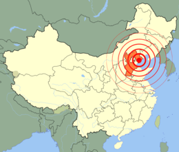
| Epicenter | 39°38′N 118°06′E / 39.63°N 118.10°E 39°43′N 118°26′E / 39.72°N 118.44°E |
| Areas affected | Hebei Province, People's Republic of China |
| Total damage | 10 billion Chinese renminbi |
| Max. intensity | XI (Extreme) |
| Casualties | 242,769[5] |
The 1976 Tangshan earthquake, also known as the Great Tangshan earthquake,[6] was a natural disaster resulting from a magnitude 7.6 earthquake that hit the region around Tangshan, Hebei, People's Republic of China on July 28, 1976, at 3:42 in the morning. In minutes the city of Tangshan, an industrial city with approximately one million inhabitants, ceased to exist. Eighty-five percent of the buildings in the city collapsed or were unusable, all services failed, and most of the highway and railway bridges collapsed or were seriously damaged.[7] At least 242,000 people died (some have said three times that), making this the third (or possibly second) deadliest earthquake in recorded history.[8]
Tangshan was the most notable of several disasters in 1976, which in Chinese tradition might signal that the government had lost political legitimacy.[9] The Tangshan earthquake also came without warning, undermining a key tenet of Maoist ideology, that earthquakes could be predicted.[10] Nonetheless, the government's response showed that it was prepared and competent to quickly provide relief.[11]
The earthquakes
The Tangshan earthquake was complex, with multiple events. The main shock struck at 3:42:56 in the morning (local time), approximately 12 km under the southern part of Tangshan.[12] The magnitude was initially estimated at around 8.1, subsequently recalculated to be 7.6 on the standard Mw scale.[13] However, that scale measures only the total energy released by an earthquake, and earthquakes vary in how much of that energy is converted to seismic shaking. The Tangshan quake, being relatively shallow, converted much of its energy to surface shaking, and on the Ms (surface magnitude) scale it also measured 7.6. (7.8 on the Chinese surface magnitude scale.[14])
The main shock "occurred on a near vertical right-lateral strike-slip fault, striking N40°E",[15] the block on the southeast side sliding about three meters to the southwest.[16] This resulted from tectonic compression on a nearly west-east axis.[17] Surface rupturing occurred in five en echelon segments extending eight kilometers through the center of Tangshan.[18]
A long sequence of aftershocks followed, with twelve of magnitude 6 or greater.[19] The first of these struck just three and a half hours later, at 7:17, at the southern end of Tangshan fault, near Ninghe ("C" on the map),[20] with a magnitude of 6.2 Ms. The largest aftershock, with a magnitude 7.0 Mw, or 7.4 Ms, struck that afternoon at 18:45 near Luanhsien (Luanxian), about 70 km to the east-northeast ("B"), just south of the northeastern end of the Tangshan fault.[21] This occurred in a zone of north-northwest striking conjugate faults that cut across the north end of the Tangshan fault. The left-lateral motion here, along with the right-lateral motion on the Tangshan fault, suggests that as the crustal blocks to the west and east are compressed together the block between these two earthquakes is being squeezed out to the south. Another significant aftershock (Ms 6.9) occurred in November near Ninghe. Most aftershocks occurred between these end points, in a zone 140 km long and about 50 km wide.[22] Many buildings were further damaged by the aftershocks.[23]
Damage
| Extent of significant shaking |
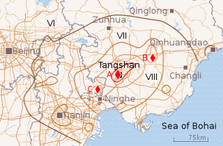 |
| Approximate extent of different intensities of shaking. Heaviest damage was within the dark brown line (intensity VII and greater). Diamonds locate the two principal shocks (A and B), and the area of several M > 6 aftershocks near Ninghe (C). |
The damage done by an earthquake depends primarily on two factors. First, the intensity of shaking, which depends mainly on the magnitude of the earthquake rupture, the distance from the epicenter, and the nature of the local soil and topography, with soft soils (e.g., sediments and fill) more likely to amplify the intensity and duration of the shaking.[24] Second, the design and construction of the structures being shaken, with houses built of adobe or stone, wooden houses without a well-built frame, and unreinforced masonry construction being especially vulnerable.[25] In this respect Tangshan was very unfortunate, in that the seismic risk had been greatly underestimated, and almost all buildings and structures were designed and built without seismic considerations.[26] As a result, Tangshan was "mainly a city of unreinforced brick buildings",[27] sitting right on top of a major earthquake.
The power (magnitude) of the Tangshan earthquake is indicated by the extent of where it was felt: up to 1,100 km (680 mi) away, across most of northeastern China, and even in Mongolia and Korea.[28] In and around Beijing, 140 km (87 mi) from the epicenter, the shaking reached an intensity of VI on the Chinese intensity scale (similar to the Modified Mercalli Intensity Scale), with nearly 10% of all buildings damaged,[29] and at least 50 people died.
The economic loss totaled to 10 billion yuan.[30]
Intensity XI and X zone
Tangshan was not so fortunate. The rupture occurred under the southern part of the city, and propagated northeastward on a fault that runs through the middle of the city. The maximum intensity was "XI" (eleven) on the 12-degree Chinese scale. Nearly every building and structure in the city collapsed, wholly or partially, infrastructure was severely damaged, and essential services such as electric power, water supply, and communications were entirely knocked out. This area of maximum damage – the meizoseismal area – was approximately 10.5 kilometres (6.5 mi) long and from 3.5 to 5.5 km wide, centered roughly along the railway.[31]
The area of intensity X shaking – where only new, one-story brick buildings were merely "damaged or slightly damaged", the rest being severely damaged or worse – was 36 km long and 15 km across.[32] In this "high intensity" zone (intensity X and XI, within the red contour on the map) 20 highway bridges and five railway bridges cross the Douhe River in Tangshan; only six survived with only minor damage.[33]
Intensity IX and VIII zone
Shaking of intensity IX (or greater) occurred in a zone roughly 78 km (48 mi) long and 42 km (26 mi) (about 1800 km2, inner orange contour on the map), and also around the aftershocks at Luanxian and Ninghe. In this zone most buildings classified as Class III (well-built buildings of wood, masonry, or reinforced concrete[34]) survived,[35] but many Class II buildings (typically old wood-frame buildings lacking a well-built frame, and quite common outside of the cities) were destroyed, while a majority of Class I buildings (built of adobe or stone) were destroyed.
Further out (to the outer orange contour), and around the city of Tianjin and a few isolated patches, intensity VIII shaking mostly affected Class I buildings (more than half destroyed), bridges, and tall brick chimneys. Railway track was also subject to bending or displacement, depending on soil conditions.[36]
Intensity VII zone
The zone of intensity VII shaking – inside the dark brown contour – marks the extent of moderate damage, where many Class I structures (of weak design or construction) were damaged but only "few" — between 10% and 30% — were destroyed, and only a "few" Class two buildings damaged. This ellipsoid zone extended about 75 km north and south of Tangshan and 120 km east and west, from about 25 km short of Beijing to short of Qinhuangdao City (which had anomalously higher shaking), and from the Sea of Bohai in the south and southwest to just north of Zunhua. The north-south shortening of this zone is attributed to buttressing by the bedrock of the Yanshin mountains.
Significant damage occurred beyond this in the VI zone, but (like in Beijing) affected less than 10% of the buildings, or occurred in small localized areas.[37]
Coal mines
Mining coal is Tangshan's principal industry, and when the quake struck around 10,000 miners were underground. For the most part the mine roadways (tunnels) were not seriously damaged, but with the loss of electrical power there was no illumination (aside from headlamps), no ventilation, and no working lifts.[38] It is reported that most miners escaped within hours, but that some did not reach the surface until two weeks later.[39]
Most of the damage to the vertical shafts occurred within the first 50 meters, where they pass through the water-bearing alluvium. In many cases the concrete liner built to keep out the water cracked (particularly where not built properly), allowing a much greater inflow of water. Coupled with damage to the underground drainage system and lack of power to drive the pumps, many of the various mines flooded.[40]
Some electrical power to the mines was restored in three days, and some coal production resumed within ten days.[41] However, de-watering, overhauling of flooded electrical equipment, and rebuilding of surface buildings and structures continued for a year and a half; the pre-earthquake level of production was not reached until the end of 1977.[42]
Railways
The Beijing to Shanhaiguan Railway (built in 1887) is a double-track Class I trunk line that runs from Beijing southeast to Tianjin and Tanggu, then turns northeast to cross the Yongdingxin River and its estuary to run to Ninghe and then Tangshan. From Tangshan it continues northeast and then east to Chengli, and then to Qinhuangdao and Shanhaiguan. This is the principal connection of Beijing, Tianjin, and Tangshan to the seaports, and to Northeast China. The Tongxian to Tuozitou (within modern-day Luan County) Railway (built in 1976) is a single-track Class I trunk line that runs east from the eastern outskirts of Beijing to where it meets the Beijing to Shanhaiguan line northeast of Tangshan (near the epicenter of the M 7.1 quake).[43] All of this was built "with no consideration for earthquake resistant design",[44] although some "earthquake resistance measures" for large and medium bridges were applied following the 1975 Haicheng earthquake.
These vital arteries (and other railways and branch lines) were seriously damaged by the earthquakes, mainly in the areas of intensity IX or greater shaking.[45] (This includes a large area around Tangshan quake, and areas around Ninghe and Luanhsien following the M 6.9 and M 7.4 aftershocks.) At the time of the main quake there were 28 freight trains and 7 passenger trains traveling on the Beijing–Shanhaiguan line in the affected area; 7 freight trains and two passenger trains derailed due to derangement of the rails,[46] mostly south of Tangshan[47] where the line was built on loose alluvium, diluvium, and occasional stretches of loose sand.[48] In many of these cases – and also similar cases northeast of Tangshan, and on the Tongxian–Tuozitou line east of Fengrun – the railway embankment slumped due to weak soils. In other cases the embankment held, but transverse compression of the rails caused them to buckle.[49]
Railway operations were further impaired by the loss of communications (including signalling) and water supply (for the steam locomotives), in both cases due mainly to collapse of buildings and loss of electrical power.[50] However, the most serious damage, taking the most manpower and longest time to repair, was that involving bridges.[51] Most difficult was where soft or liquefied soil allowed the bank to slide into the river, shifting the abutments. A more frequent problem was where an approach embankment subsided, typically leaving the rails suspended from the abutment. There were numerous cases where concrete piers and abutments were damaged due to inadequate design and construction; bridges that were strengthened following the Haicheng earthquake survived with only slight damage.[52]
It was observed that at intensity VII and above damage to the roadbed was correlated mainly with loose soil and a high water table. Conversely, bridges and rails in Tangshan City, built on dense soil with a deep water table, were largely undamaged even though subject to intensity XI shaking.[53]
Over forty-two thousand people were mobilized to quickly effect emergency repair of the railways.[54] The Tongxian-Tuozitou line was opened for traffic on August 3, single track of the Beijing-Shanhaiguan line opened on August 7, and both tracks on August 10, albeit at restricted speeds over temporary bridges and at other places where repairs were not yet complete.[55]
Death toll
Estimates of the number of deaths due to the Tangshan earthquake have varied widely, and generally lack a clear (let alone authoritative) basis. One of the earliest reports outside of China came on the 28th[56] from the International Tsunami Information Center, reporting that a "violent" earthquake, initially estimated at about magnitude 8.1, had struck "in the vicinity of Peking" (the older name for Beijing). Center Director Dr. George Pararas-Carayannis was reported as saying that "if the quake hit in a populated area reports of considerable damage could be expected."[57]
News reports the next day located the quake "about 100 miles southeast of Peking and 63 miles northeast of Tientsen" (Tianjin); i.e., "almost precisely in Tangshan".[58] The Chinese Communist party's Central Committee also broadcast a statement that the quake "caused great losses to people's life and property". One of the first reports from Tangshan said "nearly every building in the city ... was flattened."[59] There were several reports of 50 people killed in Beijing, a hundred miles from the epicenter.
According to author Stephen Spignese, a "couple of days" after the quake Dr. Pararas-Carayannis gave United Press International (UPI) an estimate of 700,000 to 750,000 deaths, based on a similar sized earthquake in Shensi province in 1556 that caused 830,000 deaths.[60] Pararas-Carayannis' current web page[61] says only that "it was fairly accurately estimated that there were at least 655,000 people dead," without mentioning by whom or on what basis this estimate was made.
In August the Nationalist Chinese government in Taiwan announced that, according to their agents in China, the death toll was over 100,000, with about 900,000 injured. They also reported that "almost all buildings in Tangshan were leveled", and 80 percent of homes and buildings in Tientsin "suffered damage to some extent".[62]
The following January (1977) the Nationalists released a document they said had been presented at an emergency conference on relief work the previous August by the Hopeh Provincial Committee of the party and the Hopeh Revolutionary Committee.[63] According to this document: "in such seriously stricken areas as Tangshan municipality, and Fengnan and Feng-yun, there were 655,237 persons dead. Some 79,000 persons were seriously injured, and some 700,000 persons suffered various degrees of injuries." Though these figures have been widely cited, it does not appear there has ever been inquiry into how they were derived, of whether they were an initial estimate (made in the first few days following the quake), or had a more solid basis.
In following June it was reported[64] that the Chinese authorities had briefed Cinna Lomnitz (a noted Chilean/Mexican seismologist) about Tangshan. It was noted that though no figures were provided, they did not deny any published estimates.
A 1988 book by several members of the Chinese State Seismological Bureau states that no more than 242,419 people died in the quake.[65] It is unclear whether this number is merely the personal view of the authors, or an official view of the government. A webpage of the Chinese Earthquake Administration dated 2009 also attributes "242,769 deaths and 164,851 serious injuries" to the Tangshan quake.[66]
There are various reports that the "official death toll was later given by the Chinese government as 275,000",[67] but without specifying a source, and a thorough search has failed to locate any such official source in English. Chinese websites generally report only a lower bound: "more than 240,000".
Political aspects
The remarkably low death toll of the Haicheng earthquake the previous year – initially said to be less than 300,[68] much later estimated at a still very modest 2,041[69] – had been credited to measures taken in response to an accurate and timely prediction. This was touted as demonstrating the validity of the Chinese methods of earthquake prediction (including inspiration from "Mao Zedong Thought"[70]) and "the superiority of our country's socialist system!"[71]
With China in the midst of the Cultural Revolution,[72] "belief in earthquake prediction was made an element of ideological orthodoxy that distinguished the true party liners from right wing deviationists", and it was everyone's duty to criticize those who doubted the feasibility of earthquake prediction.[73] However, the complete lack of warning and hundred-fold greater death toll at Tangshan stood in stark contrast to Haicheng; it was a palpable failure of earthquake prediction that undermined the claims of superiority made for Chinese methods and the socialist system.
As a backdrop to this, and of deep concern to the Chinese Communist Party,[74] was a collectively recognized but unvoiced awareness[75] that in traditional Chinese belief, natural disasters are considered disruptions in the natural order of "heaven" (Tian) and may signify the loss of legitimacy (the "mandate of heaven") of the current government.[76] This view was underlined by a magnitude 6.7 earthquake in southwestern China just three weeks later.[77] On the other hand, an ongoing mass education campaign before the quake showed that the government was aware and concerned, and the prompt and massive response following the quake demonstrated the government's competence to alleviate suffering and restore normal production, drawing on resources from across the nation.[78] This was contrasted with the hardships faced by disaster victims (especially the poor) under previous regimes, where assistance was lacking.[79]
Geology
Tangshan lies at the northern edge of the Beijing-Tianjin-Tangshan Plain, an alluvial plain that stretches from Beijing to the Sea of Bohai.[80] This plain – the northeastern corner of the great North China Plain – is where sediments eroded from the Yanshan mountains to the north have filled in the ancient Sea of Bohai, with Tangshan near where the shore was about 4,000 years ago.[81] To the south these sediments have formed a layer of weak soils as much as three kilometers thick. At Tangshan and northward these sediments are thinner where the underlying strata crops out to form isolated hills.[82] This underlying strata is a thick (typically 10 km) layer of mainly sedimentary strata such as limestone and sandstone, with large deposits of coal.[83] Tangshan is located particularly over a northeast oriented syncline, a fold in the sedimentary strata that has brought massive deposits of coal close enough to the surface to be mined. In this area the overlying alluvium varies in thickness from several meters to around 600 m (2,000 ft).[84]
Underlying all this is the ancient bedrock of different kinds of metamorphic rock (such as schist, gneiss, quartz, granulite, etc.) that form the Eastern Block of the North China Craton.[85] This craton was formed approximately two billion years ago[86] by the collision of two major crustal blocks that left a belt of uplifted mountains – the Central Orogenic Belt (COB) – that crosses China approximately southwest to northeast, passing just west and north of Beijing.[87] Just north of Zunhua another orogenic belt, the east-west trending Yanshan mountain fault-fold belt (also known as the Yanshan seismic belt) marks the northern edge of the North China Craton (and of the alluvial plain). It is also the location of over half of the destructive earthquakes in Hebi province,[88] as under the plain several fault zones (oriented parallel to the Central Orogenic Belt) terminate against the Yanshan mountains.
Many of these faults are ancient, but have been reactivated by the force transmitted from the collision of the Indian Plate against the Eurasian Plate,[89] making the Eastern Block unusually active seismically, accounting for six of the ten deadliest earthquakes in recorded history.[90]
The Tangshan fault that ruptured 28 July runs right under the center of Tangshan City.[91] One of three faults in the Changdong fault zone, it runs approximately east-northeast (ENE) about 36 km to where it terminates against the north-south trending fault where, just to the south, the secondary M 7.1 quake occurred ("B" on the map).[92] The southern end of the Tangshan fault (it bends slightly at Tangshan) is near Ninghe, which was also the site of a M 6.2 earthquake several hours after the main shock, and an M 6.9 quake ("C") the following November. The Tangshan fault is considered shallow, but corresponds with a deeper and younger fault with somewhat differing characteristics.[93]
Predicted?
The evident failure to predict the Tangshan earthquke has had considerable political as well as seismological significance.
The 1975 Haicheng earthquake (about 400 km [250 miles] northeast of Tangshan) was widely hailed as the first (and only) successful prediction of a major earthquake, demonstrating both that earthquakes could be predicted, and that the Chinese were successfully doing so.[94] The surprisingly light death toll — initial reports were of "very few people killed",[95] but later determined to be 2,041[96] — for this magnitude Ms 7.5[97] quake, attributed to the precautionary measures taken following a definite prediction, was proclaimed as a demonstration of the superiority of China's socialist system,[98] and incidentally a validation of the eclectic Chinese methodologies.
Seventeen months later the 242,419 fatalities of the similarly sized Tangshan earthquake was therefore a considerable shock politically as well as seismically. While some of this greater mortality might be attributed to the exposure of a larger population, or the time of day (Haicheng was struck in the early evening, Tangshan while most people were asleep), the principal factor seems to be the failure to take any precautionary measures: Tangshan was caught completely off-guard.
Whether the quake was predicted, or not, is a key question as to why Tangshan was unprepared. And if not, then why did the much vaunted Chinese methods (mainly of watching for various precursors, including foreshocks,[99] seemingly so successful at Haicheng and elsewhere,[100] fail to warn of this disaster? Many seismologists consider the Tangshan earthquakes to have not been predicted,[101] even "famously unpredicted",[102] and one argued that it was not predictable [103] due to a lack of precursory anomalous phenomena. Particularly pertinent here is the finding of an investigation 30 years later that at Haicheng there was no official short-term prediction of an imminent earthquake, and that though there were many unofficial predictions of an imminent quake, none of those had a scientific basis.[104] The warnings that were made and precautions taken happened largely at the local level, based on general middle-term predictions, enhanced public awareness due to an educational campaign,[105] and a series of foreshocks ("powerful messages from nature"[106]). It is significant that at Tangshan there were no perceptible foreshocks.[107]
On the other hand, it is reported[108] that several people at the State Seismological Bureau (SSB) wanted to warn of an impending earthquake somewhere in the region between Beijing and the Bohai Sea, and that this was discussed at several meetings. One of these was a week-long national conference on earthquake predictions and preparation that convened in Tangshan on July 14 (two weeks before the earthquake) where Wang Chengmin is said to have warned there could be a magnitude 5+ earthquake in the Tangshan—Luanxian area between July 22 and August 5.[109] Why no action was taken is unclear, but it seems that in addition to the distractions of the Cultural Revolution there was disagreement within the SSB on whether the next large earthquake would be in eastern China (i.e., Beijing area) or western China,[110] and that in May it had been concluded that no major earthquakes would occur in the Beijing–Tangshan area.[111] (As it turned out, western China was hit by the magnitude 7.2 Songpan-Pingwu earthquake just three weeks after Tangshan,[112] showing that those arguing for the imminence of an earthquake in Western China were not entirely incorrect.)
At another meeting, on July 26, it seems there was a suggestion to not issue any warning, to avoid alarming the population.[113] The next morning, at an emergency meeting he requested with the Bureau's leadership, Wang was reportedly told by Deputy Chief Cha Zhiyuan that "We are currently very busy. We will discuss it again next week."[114] However, Cha has disputed this, claiming that Wang said there would be no major earthquakes.[115] Another account says Wang was directed to submit more information, then send a small group to observe the earthquake.[116]
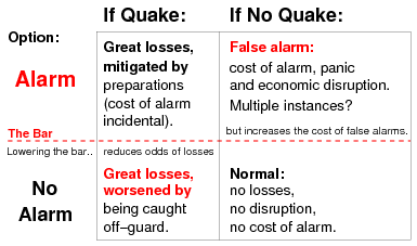
Some of the bureaucratic reticence to issue warnings and order precautionary measures likely resulted from too many predictions. These were often based on doubtful theories notorious for false alarms[117] that earthquakes can be predicted on the basis of droughts,[118] daily temperatures,[119] variations in geomagnetism,[120] or isolated anomalous phenomena. They were often too broad (magnitude "of at least 4.0 in the area of Beijing, Tianjin, Huailai, Tangshan, Bohai, and Zhangjiakou",[121] "in a few years"[122]) to warrant large-scale societal and economic disruption. Such disruptions could be serious: a false alarm in October, 1976, issued by the Sha'anxi provincial government, is estimated to have disrupted the lives of 65% of the population of that province for half a year.[123] It has also been estimated that "in the fall of 1976 about 400 million of the then total population of 930 million of China spent some nights in temporary earthquake shelters."[124] This illustrates the classic dilemma of earthquake prediction: increasing the sensitivity to the possibility of an earthquake (i.e., reducing the failure to predict) increases the number false alarms, which often has a significant cost.[125]
Comparison
Within China's geography, the deadliest known earthquake in history occurred in 1556 in Shaanxi. The 1556 Shaanxi earthquake is estimated to have killed 830,000 people, although figures from this period are hard to verify.[126] The 1920 Haiyuan earthquake in Gansu Province killed an estimated 235,000. In 1927 another earthquake struck in the same area, this time at Xining; measuring 8.6 on the Richter scale, it resulted in 200,000 deaths. Among the earthquakes that caused an extreme loss of life in the same decade is the 1923 Great Kantō earthquake, which killed 143,000 in Tokyo in 1923.
The 2008 Sichuan earthquake was equally powerful at 8.0 on the Richter scale. However, it occurred in a mountainous region where relief efforts were noticeably hampered by the geographical make-up of the land nearby. Nevertheless, the Sichuan earthquake had a much quicker and more organized response system than Tangshan, as the political, social and technological environment was different. The Chinese government allowed international aid and open media access to the disaster area.
See also
- 1975 Haicheng earthquake
- 1976 Longling earthquake (May 29)
- 1976 Songpan–Pingwu earthquake (August 16–23)
- 2008 Sichuan earthquake ("Great Wenchuan earthquake")
- List of earthquakes in 1976
- List of earthquakes in China
Notes
- ↑ ISC-EHB Event 711732 [IRIS].
- ↑ ISC-EHB Event 711773 [IRIS].
- ↑ ISC-EHB Event 711732 [IRIS].
- ↑ ISC-EHB Event 711773 [IRIS].
- ↑ CEA 2009.
- ↑ So-called by numerous sources, of which the voluminous work edited by Housner & He (2002) is the most notable.
- ↑ Housner & He 2002, Prologue.
- ↑ See the #Death toll section for the various fatality figures.
- ↑ Yeoh 2010, p. 273; Press et al. 1975, p. 879.
- ↑ Cha 1976, p. 7.
- ↑ Raleigh et al. 1977, p. 259.
- ↑ Jennings 1980, p. 69.
- ↑ ISC-EHB Event 711732 [IRIS].
- ↑ Zhu 2002, p. 6.
- ↑ Butler, Stewart & Kanamori 1979, p. 207. See figure 12 (p. 218) for an illustration. See also Zhu 2002, p. 8, Guo 2002, pp. 33–34.
- ↑ Jennings 1980, p. 89.
- ↑ Lomnitz & Lomnitz 1978, p. 109; Jennings 1980, p. 88.
- ↑ Jennings 1980, p. 89, and see figure 4.17.
- ↑ Lomnitz & Lomnitz 1978, p. 109.
- ↑ Zhu 2002, p. 8, and see Table 4, p. 12.
- ↑ Jennings 1980, pp. 88, 92.
- ↑ Jennings 1980, p. 88, and see figure 15 in Guo 2002, p. 45.
- ↑ Jennings 1980, p. 75.
- ↑ Butler, Stewart & Kanamori 1979, pp. 217–218. See also Jennings 1980, figure 4.23, which plots damage as a function of epicentral distance and a measure of building strength.
- ↑ Jennings 1980, p. 19.
- ↑ Jennings 1980, p. 75.
- ↑ Jennings 1980, p. 69.
- ↑ Jennings 1980, p. 69; Yang 2002b, p. 176 [6].
- ↑ Yao 2002, p. 244 [74].
- ↑ Stoltman, Lidstone & Dechano 2004.
- ↑ Yang 2002b, p. 172, and see figure 2, p. 182. An isoseismal map can be found in the front matter of Volume 4.
- ↑ Yang 2002b, p. 172.
- ↑ Mao, Liang & Cui 2002, p. 231
- ↑ Jennings 1980, p. 10.
- ↑ Yang 2002b, p. 180, Table 1.
- ↑ Yang 2002b, p. 172.
- ↑ Xu 2002, p. 242.
- ↑ Zhao 2002, p. 626.
- ↑ Housner & He 2002, pp. 26–27; Wang, Cui & Liu 2002, p. 749.
- ↑ Zhao 2002, p. 627.
- ↑ Mi 2002, p. 765.
- ↑ Mi 2002, p. 765.
- ↑ Liao & Gu 2002, p. 1, and see figures 1 and 4, pp. 40 and 41.
- ↑ Liao & Gu 2002, p. 1.
- ↑ Liao & Gu 2002, figure 4.
- ↑ Liao & Gu 2002, p. 2.
- ↑ Liao & Gu 2002, figure 1.
- ↑ Liao & Gu 2002, p. 1.
- ↑ Liao & Gu (2002, pp. 20+) has pictures.
- ↑ Liao & Gu 2002, pp. 1, 2, 15–16, 18.
- ↑ Liao & Gu 2002, pp. 8–10.
- ↑ Liao & Gu 2002, pp. 1. Strengthening is primarily a matter of "joining beam ends" securely so they do not pull apart, crush together, or slip off of a support.
- ↑ Liao & Gu, pp. 1–2, 8.
- ↑ Wang, Cui & Liu 2002, p. 750.
- ↑ Liao & Gu 2002, pp. 1.
- ↑ From United Press International (UPI), and carried by many newspapers.
- ↑ UPI: as carried by The Daily Texan, 28 July 1976, page 3.
- ↑ UPI: in The Daily Freeman (Kingston), 29 July 1976, p. 32.
- ↑ UPI: in The Berkshire Eagle, 30 July 1976, p. 1.
- ↑ Spignese (2005, pp. 47–48) quotes from a geocities.com webpage of "Dr. George" that is no longer available. Spignese quotes Pararas-Carayannis as saying that, in the 1556 earthquake, "in some counties the average death toll was 60 percent of the total population", and that it was reasonable to expect a similar proportion of deaths at Tangshan since the magnitudes were similar (assuming that the intensity of ground-shaking was also similar), and "since construction standards for this rural area had not changed significantly" (Spignese 2005, pp. 47–48). However, that premise is false: the large death toll in Shaanxi (Shensi) has been attributed to the yaodong style of construction peculiar to that region, where rooms, and entire buildings, are carved out of a thick layer of soft sediments (loess) that blankets the region, leaving walls of weak material similiar to adobe to support the roof (Golany 1992, pp. 7,1).
- ↑ "The China Earthquake of 1976", retrieved 18 July 2018 .
- ↑ UPI: Pacific Stars and Stripes, 7 August 1976, p. 11.
- ↑ UPI: reported in The Redlands (California) Daily Facts, 5 January 1977, p. 5.
- ↑ Malcolm 1977, p. 1.
- ↑ Chen et al. 1988.
- ↑ CEA 2009.
- ↑ E.g.: Housner & He 2002, p. 17, footnote.
- ↑ Whitham et al. 1976, p. 268.
- ↑ Wang et al. 2006, p. 779.
- ↑ Raleigh et al. (1977, p. 260), quoting the Peking Review (1975, p. 20), state:
The link between politics and earthquake prediction is well expressed by the following statement: 'This is eloquent proof that in socialist New China, under the leadership of Chairman Mao and the Communist Party and by relying on the masses and professional seismological workers armed with Marxism - Leninism - Mao Tze-tung thought and preserving in practice and summing up experience conscientiously, not only can signs indicating an earthquake be observed but predictions and forecasts can be made and damage can be greatly minimized by doing a good job of precautionary work'.
See also Cha (1976, p. 7), attributing achievement of rapid progress to "the victory of our great proletarian cultural revolution. - ↑ From a Xinhua News Agency press release published in all major Chinese newspapers 13 March 1975, quoted in Wang et al. 2006, p. 781. See also Chu 1976, p. 11, quoted in Geller 1997, p. 434.
- ↑ Wang et al. 2006, Appendix E has a concise description of the Cultural Revolution.
- ↑ Raleigh et al. 1977, p. 266; Cha 1976, p. 7.
- ↑ Xia 2013, p. 80.
- ↑ Li 2011, p. 240.
- ↑ Yeoh 2010, p. 273; Xiao 2013, p. 208.
- ↑ ANSS: Sichuan 1976. See 1976 Songpan–Pingwu earthquake.
- ↑ Raleigh et al. 1977, pp. 258–259.
- ↑ Raleigh et al. 1977, pp. 259–260.
- ↑ Jennings 1980, p. 77.
- ↑ Jennings 1980, pp. 84–85, and see figure 4.14.
- ↑ Jennings 1980, p. 84; Xing & Zou 2002, p. 88.
- ↑ Guo 2002, p. 27.
- ↑ Zhao 2002, p. 626.
- ↑ Guo 2002, p. 27.
- ↑ Some say 1.8 Ga, others 2.5. See Kusky & Li 2003 and Kusky, Windley & Zhai 2007, p. 20 for details.
- ↑ Kusky, Windley & Zhai 2007, p. 3.
- ↑ Yang 2002a, p. 50.
- ↑ Yang 2002a, p. 50.
- ↑ Kusky, Windley & Zhai 2007, p. 20.
- ↑ Jennings 1980, p. 89.
- ↑ See figure 16 in Zhu 2002, p. 23, and figure 13 in Guo 2002, p. 43. The secondary quake occurred on a north oriented section of a fault in a zone that, coming from the southeast, turns north, and then gets complicated.
- ↑ Guo 2002, pp. 30–31.
- ↑ Geller 1997, p. 434; Wang et al. 2006, p. 757.
- ↑ Hammond 1976.
- ↑ Wang et al. 2006, p. 779.
- ↑ ISC-EHB Event 711732 [IRIS].
- ↑ Wang et al. 2006, p. 781.
- ↑ Lomnitz & Lomnitz 1978, pp. 109–110.
- ↑ Lomnitz & Lomnitz (1978, p. 109) mention "the Lungling and Yenyuen earthquakes, both accurately predicted". See also Jennings 1980 (p. 6) and Chen & Wang 2010 re the Sungpan—Pingwu (or Songpan) earthquake.
- ↑ Jennings 1980, p. 6; Geller 1997, p. 434; ICEF 2011, p. 351.
- ↑ Scholz 1997.
- ↑ Lomnitz & Lomnitz 1978, p. 109.
- ↑ Wang et al. 2006, p. 785.
- ↑ See also Jennings 1980, pp. 64–67.
- ↑ Wang et al. 2006, p. 777.
- ↑ Jennings 1980, p. 81.
- ↑ Bo 2010, Chapter 7.
- ↑ Bo 2010, p. 281.
- ↑ Bo 2010, p. 281.
- ↑ Bo 2010, p. 284.
- ↑ Chen & Wang 2010, p. 2844.
- ↑ Bo 2010, p. 282.
- ↑ Bo 2010, p. 283.
- ↑ Bo 2010, p. 284.
- ↑ Peng 2008, p. 9
- ↑ Chen & Wang 2010, p. 2847.
- ↑ Bo 2010, p. 279.
- ↑ Bo 2010, p. 286.
- ↑ Bo 2010, p. 281.
- ↑ Bo 2010, p. 281.
- ↑ Bo 2010, p. 287.
- ↑ Chen & Wang 2010, p. 2846.
- ↑ Chen & Wang 2010, p. 2846, citing a Chinese source.
- ↑ ICEF 2011, p. 351.
- ↑ International Association of Engineering Geology International Congress. Proceedings. [1990] (1990). ISBN 90-6191-664-X.
Sources
- ANSS, "Sichuan 1976", Comprehensive Catalog, U.S. Geological Survey .
- Bo, Zhiyue (2010), "Chapter 7, Sichuan Earthquake", China's Elite Politics: Governance and Democratization, Series on Contempoary China, 19, ISBN 978-981-283-672-4
- Butler, Rhett; Stewart, Gordon S.; Kanamori, Hiroo (February 1979), "The July 27, 1976 Tangshan, China earthquake—A complex sequence of intraplate events" (PDF), Bulletin of the Seismological Society of America, 69 (1): 207–220
- Cha, Chi-Yuan (August 1976), "General Conditions of Earthquake Studies and Actions in China", in Muller, Paul M., Proceedings of Lectures by the Seismological Delegation of the PRC (PDF), Special Report 43-32, Jet Propulsion Laboratory, pp. 5–11 . English translation by JPL of a lecture originally published in 1976 in a special issue of the Journal of the Seismological Society of Japan (in Japanese).
- Chen, Yong; Tsoi, Kam-Ling; Chen, Feibi; Gao, Zhenhuan; Zou, Qijia; Chen, Zhangli, eds. (1988), The Great Tangshan Earthquake of 1976: An Anatomy of Disaster, Oxford: Pergamon Press, p. 153, ISBN 978-0080348759, LCCN 88005916
- Chen, Qu-Fu; Wang, Kelin (November 2010), "The 2008 Wenchuan Earthquake and Earthquake Prediction in China", Bulletin of the Seismological Society of America, 100 (5B): 2840–2857, Bibcode:2010BuSSA.100.2840C, doi:10.1785/0120090314
- Chinese Earthquake Administration (5 May 2009), "二十世纪以来死亡人数最多的地震" [The most deadly earthquake since the twentieth century] .
- Chu, Fung-Ming (August 1976), "Outline of Prediction and Forecast of Haicheng Earthquake of M=7.3", in Muller, Paul M., Proceedings of Lectures by the Seismological Delegation of the PRC (PDF), Special Report 43-32, Jet Propulsion Laboratory, pp. 11–19 . English translation by JPL of a lecture originally published in 1976 in a special issue of the Journal of the Seismological Society of Japan (in Japanese).
- Geller, Robert J. (December 1997), "Earthquake prediction: a critical review" (PDF), Geophysical Journal International, 131 (3): 425–450, Bibcode:1997GeoJI.131..425G, doi:10.1111/j.1365-246X.1997.tb06588.x
- Golany, Gideon S. (1992), Chinese Earth-Sheltered Dwellings: Indigenous Lessons for Modern Urban Design, University of Hawaii Press, ISBN 978-0-8248-1369-7
- Guo, Shunmin (2002), "Occurrence of the Tangshan Earthquake from the View of Fault Block Movement", in Housner, George W.; He, Duxin, Report On The Great Tangshan Earthquake of 1976, Volume 1, Pasadena, California: Earthquake Engineering Research Laboratory, California Institute of Technology, pp. 24–47
- Hammond, Allen L. (7 May 1976), "Earthquakes: An evacuation in China, a warning in California", Science, 192 (4239): 538–539, Bibcode:1976Sci...192..538H, doi:10.1126/science.192.4239.538, PMID 17745640 .
- Housner, George W.; He, Duxin, eds. (2002), "Overview Volume" (PDF), Report On The Great Tangshan Earthquake of 1976, Pasadena, California: Earthquake Engineering Research Laboratory, California Institute of Technology . English translation of the Chinese report of 1986.
- International Commission on Earthquake Forecasting for Civil Protection (30 May 2011), "Operational Earthquake Forecasting: State of Knowledge and Guidelines for Utilization", Annals of Geophysics, 54 (4): 315–391, doi:10.4401/ag-5350 .
- International Seismological Centre, ISC-EHB Bulletin, Thatcham, United Kingdom, http://www.isc.ac.uk/ .
- Jennings, Paul C. (1980), "Chapter 4: Report on the Tangshan Earthquake", Earthquake Engineering and Hazards Reduction in China: A Trip Report of the American Earthquake Engineering and Hazards Reduction Delegation, National Academy of Sciences, pp. 69–133, ISBN 978-0-309-02937-7
- Kusky, Timothy M.; Li, Jianhai (December 2003), "Paleoproterozoic tectonic evolution of the North China Craton" (PDF), Journal of Asian Earth Sciences, 22 (4): 383–397, Bibcode:2003JAESc..22..383K, doi:10.1016/S1367-9120(03)00071-3
- Kusky, Timothy M.; Windley, B. F.; Zhai, M.-G. (2007), Zhai, M.-G.; Windley, B. F.; Kusky, T. M.; Meng, Q. R., eds., "Tectonic evolution of the North China Block: from orogen to craton to orogen" (PDF), Mesozoic Sub-Continental Lithospheric Thinning Under Eastern Asia, Special Publications 280, Geological Society, 280, pp. 1–34, doi:10.1144/SP280.1
- Li, Lisa Yinghong (2016), "Chapter 21: Experiencing Disasters in Two Places: China's 1976 Tangshan Earthuake and Japan's 2011 Earthquake, Tsunami, and Nuclear Radiation", in Karan, Pradyumna P.; Suganuma, Unryu, Japan after 3/11: Global Persepctives on the Earthquake, Tsunami, and Fukushima Meltdown, pp. 417–431, ISBN 978-0-8131-6730-5
- Liao, Shuqiao; Gu, Zuoqin (2002), "Damage to Railway Engineering" (PDF), in Housner, George W.; He, Duxin, Report On The Great Tangshan Earthquake of 1976, Volume 1, Pasadena, California: Earthquake Engineering Research Laboratory, California Institute of Technology, pp. 1–59
- Lomnitz, Cinna; Lomnitz, Larissa (12 January 1978), "Tangshan 1976: a case history in earthquake prediction", Nature, 271 (5641): 109–111, Bibcode:1978Natur.271..109L, doi:10.1038/271109a0 .
- Malcolm, Andrew H. (2 June 1977), "Chinese Disclose That 1976 Quake Was Deadliest in Four Centuries", New York Times, p. 1 .
- Mao, Yingsheng; Liang, ZhiJiang; Cui, Cui (2002), "Lightly Damaged Bridges in the High Intensity Earthquake Zone", in Housner, George W.; He, Duxin, Report On The Great Tangshan Earthquake of 1976, Volume 3, Pasadena, California: Earthquake Engineering Research Laboratory, California Institute of Technology, pp. 231–242
- Mi, Enli (2002), "The Repair and Resoration of the Kailuan Coal Mine" (PDF), in Housner, George W.; He, Duxin, Report On The Great Tangshan Earthquake of 1976, Volume 3, Pasadena, California: Earthquake Engineering Research Laboratory, California Institute of Technology, pp. 747–764
- Palmer, James (2012), Heaven Cracks, Earth Shakes: The Tangshan Earthquake and the Death of Mao's China, Basic Books, ISBN 978-0-465-01478-1 .
- "Southern Liaoning: Results of earthquake prediction and forecasting" (PDF), Peking Review, 18 (12), pp. 20–21, March 21, 1975
- Pelling, Mark; Dill, Kathleen (2006), "'Natural' Disasters as Catalysts of Political Action" (PDF), Burmalibrary.org, ISP/NSC Briefing paper .
- Peng, Funan (June 2008), "The success of the prediction of Haicheng earthquake and the negligence of the Tangshan earthquake", Engineering Sciences, 6 (2): 9–18
- Press, Frank; Bullock, Mary; Hamilton, Robert M.; Brace, William F.; Kisslinger, Carl; Bonilla, Manuel G.; Allen, Clarence C.; Sykes, Lynn R.; Raleigh, C. Barry; Knopoff, Leon; Clough, Ray W.; Hofheinz, Roy (1975), "Earthquake Research in China", Eos, Transactions, American Geophysical Union, 56 (11): 838–881, doi:10.1029/EO056i011p00838 . The "American Seismological Delegation".
- Raleigh, C. B.; Bennett, G.; Craig, H.; Hanks, T.; Molnar, P.; Nur, A.; Savage, J.; Scholz, C.; Turner, R.; Wu, F. (May 1977), "Prediction of the Haicheng earthquake", Eos, Transactions, American Geophysical Union, 58 (5): 236–272, Bibcode:1977EOSTr..58..236., doi:10.1029/EO058i005p00236 .The Haicheng Earthquake Study Delegation.
- Scholz, Christopher (March 1997), "What Ever Happened to Earthquake Prediction?", Geotimes, 42 (3)
- Spence, Jonathan (1991), The Search for Modern China, W. W. Norton & Company, ISBN 978-0-393-30780-1 .
- Spignesi, Stephen J. (2005), "Chapter 15: The 1976 Tangshan, China, Earthquake", Catastrophe!: The 100 Greatest Disasters of All Time, ISBN 978-0-8065-2558-7 .
- State Council Document No. 69, 29 June 1974, archived from the original on 2009-10-02, retrieved 2011-03-21 .
- Stoltman, Joseph P.; Lidstone, John; Dechano, M. Lisa. (2004), International Perspectives On Natural Disasters, Springer Publishing, ISBN 978-1-4020-2850-2 .
- Wang, Kelin; Chen, Qi-Fu; Sun, Shihong; Wang, Andong (June 2006), "Predicting the 1975 Haicheng Earthquake" (PDF), Bulletin of the Seismological Society of America, 96 (3): 757–795, Bibcode:2006BuSSA..96..757W, doi:10.1785/0120050191 .
- Wang, Zixing; Cui, Xifu; Liu, Keren (2002), "Disaster Relief After the Tangshan Earthquake" (PDF), in Housner, George W.; He, Duxin, Report On The Great Tangshan Earthquake of 1976, Volume 3, Pasadena, California: Earthquake Engineering Research Laboratory, California Institute of Technology, pp. 747–764
- Whitham, K.; Berry, M.J.; Heidebrecht, A.C.; Kanasewich, E.R.; Milne, W.G (1976), "Earthquake Prediction in China", Geoscience Canada, 3 (4): 96, 263–268 .
- Xiao, Yuefan (October 2013), The Politics of Crisis Management in China [dissertation] (PDF)
- Xing, Jiaming; Zou, Baoshan (2002), "Geomorphologic Characteristics in the Beijing–TianjinT–angshan Area and Their Relation with Tectonic Activity" (PDF), in Housner, George W.; He, Duxin, Report On The Great Tangshan Earthquake of 1976, Volume 1, Pasadena, California: Earthquake Engineering Research Laboratory, California Institute of Technology, pp. 85–98
- Xu, Wei (2002), "Earthquake Intensity Distribution in the City of Beijing" (PDF), in Housner, George W.; He, Duxin, Report On The Great Tangshan Earthquake of 1976, Volume 1, Pasadena, California: Earthquake Engineering Research Laboratory, California Institute of Technology, pp. 241–243
- Yang, Lihua (2002a), "Geologic-Tectonic Background and Seismogenic Structure of the Tangshan Earthquake" (PDF), in Housner, George W.; He, Duxin, Report On The Great Tangshan Earthquake of 1976, Volume 1, Pasadena, California: Earthquake Engineering Research Laboratory, California Institute of Technology, pp. 85–98
- Yang, Lihua (2002b), "Distribution and Ground Failure Intensity Distribution of the Tangshan Earthquake" (PDF), in Housner, George W.; He, Duxin, Report On The Great Tangshan Earthquake of 1976, Volume 1, Pasadena, California: Earthquake Engineering Research Laboratory, California Institute of Technology, pp. 171–183
- Yao, Binghua (2002), "Earthquake Damage Distribution in the City of Beijing" (PDF), in Housner, George W.; He, Duxin, Report On The Great Tangshan Earthquake of 1976, Volume 1, Pasadena, California: Earthquake Engineering Research Laboratory, California Institute of Technology, pp. 244–248
- Yeoh, Emile Kok-Kheng (October 2010), "Changing China: Three Decades of Social Transformation", International Journal of China Studies, 1 (2): 239–308, ISSN 2180-3250 .
- Zhao, Yucheng (2002), "Earthquake Damage to Shafts and Roadways in Kailuan" (PDF), in Housner, George W.; He, Duxin, Report On The Great Tangshan Earthquake of 1976, Volume 2, Pasadena, California: Earthquake Engineering Research Laboratory, California Institute of Technology, pp. 625–645
- Zhu, Chuanzhen (2002), "Seismic Activity in Tangshan and its Surrounding Areas" (PDF), in Housner, George W.; He, Duxin, Report On The Great Tangshan Earthquake of 1976, Volume 1, Pasadena, California: Earthquake Engineering Research Laboratory, California Institute of Technology, pp. 1–23
Further reading
- Qian Gang. The Great China Earthquake. Beijing: Foreign Languages Press, 1989. ISBN 0835122271.
- James Palmer. Heaven Cracks, Earth Shakes: The Tangshan Earthquake and the Death of Mao's China. New York, NY: Basic Books, 2011. ISBN 978-0-465-01478-1 (hardcover alk. paper) 9780465023493 (ebk. alk. paper).
- Report on The Great Tangshan Earthquake of 1976: English translation of an extensive Chinese report from 1986.
External links
- "Integration of Public Administration and Earthquake Science: The Best Practice Case of Qinglong County" at GlobalWatch.org
- The International Seismological Centre has a bibliography and/or authoritative data for this event.
- An isoseismal map (showing the different zones of shaking intensity) of the Tangshan earthquake can be found here.