Törökszentmiklós
| Törökszentmiklós | ||
|---|---|---|
| Town | ||
| ||
 Törökszentmiklós | ||
| Coordinates: 47°11′N 20°25′E / 47.183°N 20.417°E | ||
| Country |
| |
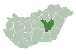
| County | Jász-Nagykun-Szolnok | |
| District | Törökszentmiklós | |
| Area | ||
| • Total | 185.16 km2 (71.49 sq mi) | |
| Population (2002) | ||
| • Total | 23,145 | |
| • Density | 125/km2 (320/sq mi) | |
| Time zone | UTC+1 (CET) | |
| • Summer (DST) | UTC+2 (CEST) | |
| Postal code | 5200 | |
| Area code | (+36) 56 | |
| Website |
www | |

Törökszentmiklós is a town in Jász-Nagykun-Szolnok county, in the Northern Great Plain region of central Hungary. It is the third-largest settlement in the county.
Geography
It covers an area of 185.16 km2 (71 sq mi) and has a population of 23,145 people (2002).
Timeline of the history of Törökszentmiklós
| B.C. | Chalcolithic-, bronze and iron age cultures, Celtic ruins. |
| 1399 | The charters of King Zsigmond mention the name Zenthmyclos. |
| 1552 | The castle of Balaszentmiklós fell under the Turkish siege. |
| 1685 | Destruction of the castle. |
| 1738 | The settlement, Török Szent Miklós became a market town. |
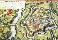
The castle from the Middle Ages.
It is home to the Törökszentmiklós palace (shown in photo).
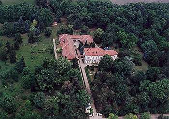
Törökszentmiklós - Palace from above
International relations
Törökszentmiklós is twinned with:


References
- ↑ , Further information
External links
| Wikimedia Commons has media related to Törökszentmiklós. |
- Official website in Hungarian
| Towns (2) |
| |
|---|---|---|
| Villages (5) |
| |
| City with county rights |
|   |
|---|---|---|
| Towns | ||
| Large villages | ||
| Villages |
| |
| Other topics |
| |
This article is issued from
Wikipedia.
The text is licensed under Creative Commons - Attribution - Sharealike.
Additional terms may apply for the media files.