Kunszentmárton
| Kunszentmárton | ||
|---|---|---|
| Town | ||
 View of Kunszentmarton's centre with Körös | ||
| ||
 Kunszentmárton Location of Kunszentmárton | ||
| Coordinates: 46°50′28″N 20°17′14″E / 46.84111°N 20.28722°ECoordinates: 46°50′28″N 20°17′14″E / 46.84111°N 20.28722°E | ||
| Country |
| |
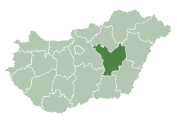
| County | Jász-Nagykun-Szolnok | |
| District | Kunszentmárton | |
| Area | ||
| • Total | 143.65 km2 (55.46 sq mi) | |
| Population (2006)[1] | ||
| • Total | 8,793 | |
| • Density | 60.34/km2 (156.3/sq mi) | |
| Time zone | UTC+1 (CET) | |
| • Summer (DST) | UTC+2 (CEST) | |
| Postal code | 5440 | |
| Area code | (+36) 56 | |
| Website |
www | |
Kunszentmárton is a small town of the county of Jász-Nagykun-Szolnok, central Hungary.
Geography
Körös River crosses the city from the north-east to the south.
International relations
Kunszentmárton is twinned with:

References
- ↑ "Magyarország közigazgatási helynévkönyve, 2013. január 1". ksh.hu. Hungarian Central Statistical Office. 2013-01-01. Retrieved 2014-01-13.
External links
| Wikimedia Commons has media related to Kunszentmárton. |
- Official website in Hungarian
| Towns (2) |
| |
|---|---|---|
| Large villages (2) | ||
| Villages (7) | ||
| City with county rights |
|   |
|---|---|---|
| Towns | ||
| Large villages | ||
| Villages |
| |
| Other topics |
| |
This article is issued from
Wikipedia.
The text is licensed under Creative Commons - Attribution - Sharealike.
Additional terms may apply for the media files.