Kétpó
| Kétpó | ||
|---|---|---|
| Village | ||
| ||
 Kétpó | ||
| Coordinates: 47°04′26″N 20°28′52″E / 47.07389°N 20.48111°ECoordinates: 47°04′26″N 20°28′52″E / 47.07389°N 20.48111°E | ||
| Country |
| |
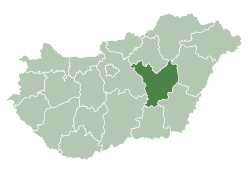
| County | Jász-Nagykun-Szolnok | |
| District | Mezőtúr | |
| Area | ||
| • Total | 66.76 km2 (25.78 sq mi) | |
| Population (2002) | ||
| • Total | 820 | |
| • Density | 12/km2 (30/sq mi) | |
| Time zone | UTC+1 (CET) | |
| • Summer (DST) | UTC+2 (CEST) | |
| Postal code | 5411 | |
| Area code(s) | (+36) 56 | |
Kétpó is a village in Jász-Nagykun-Szolnok county, in the Northern Great Plain region of central Hungary.

Aerialphotography: Kétpó, palace
Geography
It covers an area of 66.76 km2 (26 sq mi) and has a population of 820 people (2002).
External links
- Official site in Hungarian
| Towns (2) | ||
|---|---|---|
| Villages (3) | ||
| City with county rights |
|   |
|---|---|---|
| Towns | ||
| Large villages | ||
| Villages |
| |
| Other topics |
| |
This article is issued from
Wikipedia.
The text is licensed under Creative Commons - Attribution - Sharealike.
Additional terms may apply for the media files.