Szob District
| Szob District Szobi járás | ||
|---|---|---|
| Districts of Hungary | ||
| ||
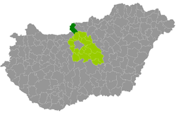 Szob District within Hungary and Pest County. | ||
| Country |
| |
| County | Pest | |
| District seat | Szob | |
| Area | ||
| • Total | 438.32 km2 (169.24 sq mi) | |
| Area rank | 5th in Pest | |
| Population (2011 census) | ||
| • Total | 24,875 | |
| • Rank | 18th in Pest | |
| • Density | 57/km2 (150/sq mi) | |
Szob (Hungarian: Szobi járás) is a district in northern part of Pest County. Szob is also the name of the town where the district seat is found. The district is located in the Central Hungary Statistical Region.
Geography
Szob District borders with the Slovakian region of Nitra to the north and west, Balassagyarmat District, Rétság District (Nógrád County) and Vác District to the east, Szentendre District to the south, Esztergom District (Komárom-Esztergom County) to the southwest. The number of the inhabited places in Szob District is 17.
Municipalities
The district has 2 towns and 15 villages. (ordered by population, as of 1 January 2013)[1]
- Bernecebaráti (904)
- Ipolydamásd (352)
- Ipolytölgyes (417)
- Kemence (990)
- Kismaros (2,093)
- Kóspallag (751)
- Letkés (1,119)
- Márianosztra (878)
- Nagybörzsöny (744)
- Nagymaros (4,756)
- Perőcsény (289)
- Szob (2,806) – district seat
- Szokolya (1,810)
- Tésa (78)
- Vámosmikola (1,644)
- Verőce (3,643)
- Zebegény (1,213)
The bolded municipalities are cities.
Demographics
Religion in Szob District (2011 census)
In 2011, it had a population of 24,875 and the population density was 57/km².
| Year | County population[2] | Change |
|---|---|---|
| 2011 | 24,875 | n/a |
Ethnicity
Besides the Hungarian majority, the main minorities are the German (approx. 900), Roma (500) and Slovak (100).
Total population (2011 census): 24,875
Ethnic groups (2011 census):[3] Identified themselves: 23,598 persons:
- Hungarians: 21,716 (92.02%)
- Germans: 865 (3.67%)
- Gypsies: 515 (2.18%)
- Others and indefinable: 502 (2.13%)
Approx. 1,000 persons in Szob District did not declare their ethnic group at the 2011 census.
Religion
Religious adherence in the county according to 2011 census:[4]
- Catholic – 13,439 (Roman Catholic – 13,316; Greek Catholic – 118);
- Reformed – 2,078;
- Evangelical – 405;
- other religions – 413;
- Non-religious – 2,456;
- Atheism – 258;
- Undeclared – 5,826.
Gallery
 Downtown of Szob
 Our Lady of Hungary Church in Márianosztra
 Panorama from Ipolytölgyes
See also
References
- ↑ A KSH 2013. évi helységnévkönyve
- ↑ népesség.com, "Szobi járás népessége"
- ↑ 4.1.6.1 A népesség nemzetiség szerint, 2011, (in Hungarian)
- ↑ 4.1.7.1 A népesség vallás, felekezet szerint, 2011, (in Hungarian)
External links
| Towns (2) | ||
|---|---|---|
| Villages (15) | ||
Coordinates: 47°49′00″N 18°52′00″E / 47.8167°N 18.8667°E