Ráckeve District
| Ráckeve District Ráckevei járás | ||
|---|---|---|
| Districts of Hungary | ||
| ||
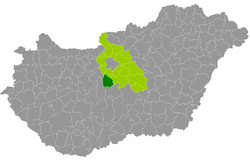 Ráckeve District within Hungary and Pest County. | ||
| Country |
| |
| County | Pest | |
| District seat | Ráckeve | |
| Area | ||
| • Total | 417.05 km2 (161.02 sq mi) | |
| Area rank | 6th in Pest | |
| Population (2011 census) | ||
| • Total | 35,732 | |
| • Rank | 16th in Pest | |
| • Density | 86/km2 (220/sq mi) | |

Ráckeve (Hungarian: Ráckevei járás) is a district in southern part of Pest County. Ráckeve is also the name of the town where the district seat is found. The district is located in the Central Hungary Statistical Region.
Geography
Ráckeve District borders with Szigetszentmiklós District to the north, Dabas District to the east, Kunszentmiklós District (Bács-Kiskun County) to the south, Dunaújváros District and Martonvásár District (Fejér County) to the west. The number of the inhabited places in Ráckeve District is 11.
Municipalities
The district has 1 town, 2 large villages and 8 villages. (ordered by population, as of 1 January 2013)[1]
- Apaj (1,224)
- Áporka (1,121)
- Dömsöd (5,795)
- Kiskunlacháza (8,855)
- Lórév (292)
- Makád (1,192)
- Ráckeve (9,965) – district seat
- Szigetbecse (1,304)
- Szigetcsép (2,282)
- Szigetszentmárton (2,133)
- Szigetújfalu (1,957)
The bolded municipality is city, italics municipalities are large villages.
Demographics
Religion in Ráckeve District (2011 census)
In 2011, it had a population of 35,732 and the population density was 86/km².
| Year | County population[2] | Change |
|---|---|---|
| 2011 | 35,732 | n/a |
Ethnicity
Besides the Hungarian majority, the main minorities are the German (approx. 1,250), Roma (800), Serb (300) and Romanian (100).
Total population (2011 census): 35,732
Ethnic groups (2011 census):[3] Identified themselves: 33,858 persons:
- Hungarians: 30,997 (91.55%)
- Germans: 1,236 (3.65%)
- Gypsies: 775 (2.29%)
- Others and indefinable: 850 (2.51%)
Approx. 2,000 persons in Ráckeve District did not declare their ethnic group at the 2011 census.
Religion
Religious adherence in the county according to 2011 census:[4]
- Catholic – 13,063 (Roman Catholic – 12,868; Greek Catholic – 195);
- Reformed – 8,123;
- Orthodox – 254;
- Evangelical – 150;
- other religions – 473;
- Non-religious – 4,199;
- Atheism – 318;
- Undeclared – 9,152.
Gallery
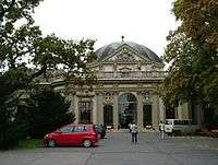
 Serbian Church of Our Lady in Ráckeve
.JPG) Landscape in Szigetcsép
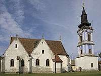
Landscape in Szigetcsép_(7115._sz%C3%A1m%C3%BA_m%C5%B1eml%C3%A9k).jpg) Zichy Memorial Chapel near Lórév
Zichy Memorial Chapel near Lórév
See also
References
- ↑ A KSH 2013. évi helységnévkönyve
- ↑ népesség.com, "Ráckevei járás népessége"
- ↑ 4.1.6.1 A népesség nemzetiség szerint, 2011, (in Hungarian)
- ↑ 4.1.7.1 A népesség vallás, felekezet szerint, 2011, (in Hungarian)
External links
| Town (1) |
| |
|---|---|---|
| Large villages (2) | ||
| Villages (8) | ||
Coordinates: 47°10′00″N 18°57′00″E / 47.1667°N 18.9500°E