Esztergom District
| Esztergom District Esztergomi járás | |||
|---|---|---|---|
| Districts of Hungary | |||
| |||
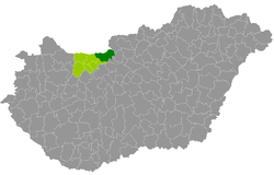 Esztergom District within Hungary and Komárom-Esztergom County. | |||
| Country |
| ||
| County | Komárom-Esztergom | ||
| District seat | Esztergom | ||
| Area | |||
| • Total | 537.26 km2 (207.44 sq mi) | ||
| Area rank | 1st in Komárom-Esztergom | ||
| Population (2011 census) | |||
| • Total | 93,784 | ||
| • Rank | 1st in Komárom-Esztergom | ||
| • Density | 175/km2 (450/sq mi) | ||

Esztergom (Hungarian: Esztergomi járás) is a district in north-eastern part of Komárom-Esztergom County. Esztergom is also the name of the town where the district seat is found. The district is located in the Central Transdanubia Statistical Region.
Geography
Esztergom District borders with the Slovakian region of Nitra to the north, Szob District and Szentendre District (Pest County) to the east, Pilisvörösvár District (Pest County) to the southeast, Tatabánya District to the southwest, Tata District to the west. The number of the inhabited places in Esztergom District is 24.
Municipalities
The district has 5 towns, 1 large village and 18 villages. (ordered by population, as of 1 January 2013)[1]
- Annavölgy (931)
- Bajna (1,937)
- Bajót (1,607)
- Csolnok (3,166)
- Dág (948)
- Dömös (1,144)
- Dorog (11,905)
- Epöl (647)
- Esztergom (28,550) – district seat
- Kesztölc (2,606)
- Lábatlan (4,968)
- Leányvár (1,744)
- Máriahalom (643)
- Mogyorósbánya (853)
- Nagysáp (1,531)
- Nyergesújfalu (7,550)
- Piliscsév (2,321)
- Pilismarót (1,991)
- Sárisáp (2,740)
- Süttő (2,061)
- Tát (5,327)
- Tokod (4,137)
- Tokodaltáró (2,922)
- Úny (673)
The bolded municipalities are cities, italics municipality is large village.
Demographics
Religion in Esztergom District (2011 census)
In 2011, it had a population of 93,784 and the population density was 175/km².
| Year | County population[2] | Change |
|---|---|---|
| 2011 | 93,784 | n/a |
Ethnicity
Besides the Hungarian majority, the main minorities are the German (approx. 4,200), Slovak (2,250), Roma (1,600) and Romanian (300).
Total population (2011 census): 93,784
Ethnic groups (2011 census):[3] Identified themselves: 88,942 persons:
- Hungarians: 79,701 (89.61%)
- Germans: 4,177 (4.69%)
- Slovaks: 2,254 (2.53%)
- Gypsies: 1,601 (1.80%)
- Others and indefinable: 1,209 (1.36%)
Approx. 5,000 persons in Esztergom District did not declare their ethnic group at the 2011 census.
Religion
Religious adherence in the county according to 2011 census:[4]
- Catholic – 42,934 (Roman Catholic – 42,524; Greek Catholic – 396);
- Reformed – 6,018;
- Evangelical – 555;
- other religions – 1,423;
- Non-religious – 14,400;
- Atheism – 1,127;
- Undeclared – 27,327.
See also
References
- ↑ A KSH 2013. évi helységnévkönyve
- ↑ népesség.com, "Esztergomi járás népessége"
- ↑ 4.1.6.1 A népesség nemzetiség szerint, 2011, (in Hungarian)
- ↑ 4.1.7.1 A népesség vallás, felekezet szerint, 2011, (in Hungarian)
External links
| Towns (5) |
| |
|---|---|---|
| Large village (1) | ||
| Villages (18) | ||