Pilisvörösvár District
| Pilisvörösvár District Pilisvörösvári járás | ||
|---|---|---|
| Districts of Hungary | ||
| ||
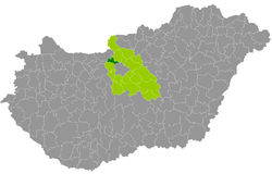 Pilisvörösvár District within Hungary and Pest County. | ||
| Country |
| |
| County | Pest | |
| District seat | Pilisvörösvár | |
| Area | ||
| • Total | 130.81 km2 (50.51 sq mi) | |
| Area rank | 16th in Pest | |
| Population (2011 census) | ||
| • Total | 53,201 | |
| • Rank | 11th in Pest | |
| • Density | 407/km2 (1,050/sq mi) | |

Pilisvörösvár (Hungarian: Pilisvörösvári járás; German: Kreis Werischwar) is a district in north-western part of Pest County. Pilisvörösvár is also the name of the town where the district seat is found. The district is located in the Central Hungary Statistical Region.
Geography
Pilisvörösvár District borders with Szentendre District to the northeast, Budapest to the southeast, Budakeszi District to the south, Esztergom District (Komárom-Esztergom County) to the northwest. The number of the inhabited places in Pilisvörösvár District is 9.
Municipalities
The district has 2 towns, 1 large village and 6 villages. (ordered by population, as of 1 January 2013)[1]
- Pilisborosjenő (3,481)
- Piliscsaba (7,950)
- Pilisjászfalu (1,571)
- Pilisszántó (2,865)
- Pilisszentiván (3,481)
- Pilisvörösvár (13,838) – district seat
- Solymár (9,901)
- Tinnye (1,604)
- Üröm (4,165)
The bolded municipalities are cities, italics municipality is large village.
Demographics
Religion in Pilisvörösvár District (2011 census)
In 2011, it had a population of 53,201 and the population density was 407/km².
| Year | County population[2] | Change |
|---|---|---|
| 2011 | 53,201 | n/a |
Ethnicity
Besides Hungarian majority, the main minorities are the German (approx. 7,000), Slovak (1,100), Roma (500), Russian and Romanian (150).
Total population (2011 census): 53,201
Ethnic groups (2011 census):[3] Identified themselves: 56,661 persons:
- Hungarians: 46,448 (81.98%)
- Germans: 7,231 (12.76%)
- Slovaks: 1,097 (1.94%)
- Others and indefinable: 1,885 (3.33%)
Approx. 3,500 persons in Pilisvörösvár District did declare more than one ethnic group at the 2011 census.
Religion
Religious adherence in the county according to 2011 census:[4]
- Catholic – 23,848 (Roman Catholic – 23,458; Greek Catholic – 384);
- Reformed – 4,318;
- Evangelical – 652;
- Orthodox – 78;
- Judaism – 76;
- other religions – 1,153;
- Non-religious – 7,577;
- Atheism – 979;
- Undeclared – 14,520.
Gallery
 Downtown of Pilisvörösvár
 Panorama of Solymár
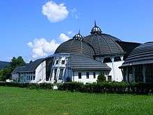
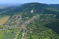 Aerial view of Pilisszántó
See also
References
- ↑ A KSH 2013. évi helységnévkönyve
- ↑ népesség.com, "Pilisvörösvári járás népessége"
- ↑ 4.1.6.1 A népesség nemzetiség szerint, 2011, (in Hungarian)
- ↑ 4.1.7.1 A népesség vallás, felekezet szerint, 2011, (in Hungarian)
External links
| Towns (2) |
| |
|---|---|---|
| Large village (1) | ||
| Villages (6) | ||
Coordinates: 47°37′00″N 18°55′00″E / 47.6167°N 18.9167°E