Rétság District
| Rétság District Rétsági járás | ||
|---|---|---|
| Districts of Hungary | ||
| ||
 Rétság District within Hungary and Nógrád County. | ||
| Country |
| |
| County | Nógrád | |
| District seat | Rétság | |
| Area | ||
| • Total | 435.03 km2 (167.97 sq mi) | |
| Area rank | 4th in Nógrád | |
| Population (2011 census) | ||
| • Total | 24,395 | |
| • Rank | 4th in Nógrád | |
| • Density | 56/km2 (150/sq mi) | |

Rétság (Hungarian: Rétsági járás; Slovak: Rétságsky okres) is a district in western part of Nógrád County. Rétság is also the name of the town where the district seat is found. The district is located in the Northern Hungary Statistical Region.
Geography
Rétság District borders with Balassagyarmat District to the northeast, Vác District (Pest County) to the south, Szob District (Pest County) to the west. The number of the inhabited places in Rétság District is 25.
Municipalities
The district has 1 town and 24 villages. (ordered by population, as of 1 January 2013)[1]
- Alsópetény (595)
- Bánk (650)
- Berkenye (614)
- Borsosberény (980)
- Diósjenő (2,768)
- Felsőpetény (590)
- Horpács (172)
- Keszeg (615)
- Kétbodony (460)
- Kisecset (160)
- Legénd (432)
- Nagyoroszi (2,143)
- Nézsa (1,092)
- Nógrád (1,389)
- Nógrádsáp (833)
- Nőtincs (1,053)
- Ősagárd (288)
- Pusztaberki (128)
- Rétság (2,777) – district seat
- Romhány (2,127)
- Szátok (618)
- Szendehely (1,515)
- Szente (329)
- Tereske (714)
- Tolmács (756)
The bolded municipality is city.
Demographics
Religion in Rétság District (2011 census)
In 2011, it had a population of 24,395 and the population density was 56/km².
| Year | County population[2] | Change |
|---|---|---|
| 2011 | 24,395 | n/a |
Ethnicity
Besides the Hungarian majority, the main minorities are the Slovak (approx. 1,300), German and Roma (850).
Total population (2011 census): 24,395
Ethnic groups (2011 census):[3] Identified themselves: 24,864 persons:
- Hungarians: 21,569 (86.75%)
- Slovaks: 1,337 (5.38%)
- Germans: 841 (3.38%)
- Gypsies: 839 (3.37%)
- Others and indefinable: 278 (1.12%)
Approx. 500 persons in Rétság District did declare more than one ethnic group at the 2011 census.
Religion
Religious adherence in the county according to 2011 census:[4]
- Catholic – 13,646 (Roman Catholic – 13,567; Greek Catholic – 77);
- Evangelical – 1,749;
- Reformed – 1,339;
- other religions – 351;
- Non-religious – 1,743;
- Atheism – 168;
- Undeclared – 5,399.
Gallery
 Rétság, Town Hall
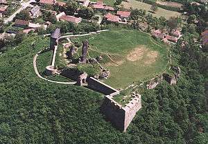 Nógrád Castle
 Gyurcsányi-Prónay Mansion in Alsópetény
 Lake Bánk
See also
References
- ↑ A KSH 2013. évi helységnévkönyve
- ↑ népesség.com, "Rétsági járás népessége"
- ↑ 4.1.6.1 A népesség nemzetiség szerint, 2011, (in Hungarian)
- ↑ 4.1.7.1 A népesség vallás, felekezet szerint, 2011, (in Hungarian)
External links
| Town (1) |
| |
|---|---|---|
| Villages (24) | ||