Razdolnaya River
| Razdolnaya or Suifen River | |
|---|---|
 | |
| Country | People's Republic of China, Russia |
| Physical characteristics | |
| Main source |
Confluence of Xiaosuifen and Dasuifen rivers 880 m (2,890 ft) |
| River mouth |
Amur Bay, Sea of Japan 0 m (0 ft) |
| Length | 242 km (150 mi) |
| Discharge |
|
| Basin features | |
| Basin size | 16,830 km2 (6,500 sq mi) |
Razdolnaya (Russian: Раздольная) or Suifen (simplified Chinese: 绥芬河; traditional Chinese: 綏芬河; pinyin: Suífēn Hé) is a river in People's Republic of China and Russia.
The name
Suifen is the Manchu word for awl, referring to the shape of a species of Oncomelania snail.[1]
In Russian, the river was originally known under the same Manchu / Chinese name (rendered as Суйфун (Suifun) in Russian). In 1972, in the aftermath of the Zhenbao Island incident (1969), toponyms of Chinese origin in Primorsky Krai were replaced en masse with newly designed Russian names; as part of this project, the Russian part of the Suifen River received the name Razdolnaya, which can be translated from Russian as "widely flowing".
Geography
The source of the Suifen River is the confluence of the Xiaosuifen (Lesser Suifen) River and the Dasuifen (Greater Suifen) River in Heilongjiang.
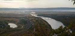
Suifenhe City was named after the Chinese name of the river. Downstream of the city, the river enters Russian territory, and flows into Amur Bay through Khanka Lowlands.
The length of the river is 242 kilometres (150 mi), of which 191 kilometres (119 mi) is in Russia; the drainage basin covers 16,830 square kilometres (6,500 sq mi).[2]
The major tributaries of the river are the Granitnaya River (99 km), the Borisovka River (86 km) and the Rakovka River (76 km).[3] Ussuriysk was founded in 1866 at the confluence of the Razdolnaya and Rakovka rivers. As Rakovka and its major tributary Komarovka are of roughly the same size and flow at their confluence some 2 km above the confluence point, there exist some controversy about exactly which river is Razdolnaya's tributary. Most maps choose to simply not mark the short stretch of the joint flow through Ussuriysk.
Notes
Heilongjiang topics | |
|---|---|
| General | |
| Geography | |
| Education | |
| Visitor attractions | |
| |
Coordinates: 43°19′32″N 131°48′28″E / 43.32556°N 131.80778°E