Strömstad Municipality
| Strömstad Municipality Strömstads kommun | ||
|---|---|---|
| Municipality | ||
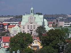 City Hall of Strömstad | ||
| ||
 | ||
| Country | Sweden | |
| County | Västra Götaland County | |
| Seat | Strömstad | |
| Area[1] | ||
| • Total | 951.83 km2 (367.50 sq mi) | |
| • Land | 467.48 km2 (180.50 sq mi) | |
| • Water | 484.35 km2 (187.01 sq mi) | |
| Area as of 1 January 2014. | ||
| Population (31 December 2017)[2] | ||
| • Total | 13,218 | |
| • Density | 14/km2 (36/sq mi) | |
| Time zone | UTC+1 (CET) | |
| • Summer (DST) | UTC+2 (CEST) | |
| ISO 3166 code | SE | |
| Province | Bohuslän | |
| Municipal code | 1486 | |
| Website | www.stromstad.se | |

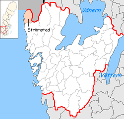
Strömstad Municipality (Strömstads kommun) is a municipality in Västra Götaland County in western Sweden. Its seat is located in the city of Strömstad.
The municipality got its present boundaries in 1967, when the City of Strömstad was merged with the two adjacent rural municipalities Tjärnö and Vette. Vette had been created in 1952 out of four older entities.
Geography
Strömstad Municipality is located on the Norwegian border and is known to attract large numbers of shoppers from Norway due to the marked price gap, notably in the tax burdend alcohol and tobaccos, but also groceries such as meat and sugar. There are also a great deal to save on automotive services.
Localities
- Kebal
- Koster Islands
- Skee
- Strömstad (seat)
References
- ↑ "Statistiska centralbyrån, Kommunarealer den 1 januari 2014" (Microsoft Excel) (in Swedish). Statistics Sweden. Retrieved 2014-04-18.
- ↑ "Folkmängd i riket, län och kommuner 31 december 2017" (in Swedish). Statistics Sweden. February 21, 2018. Retrieved February 21, 2018.
External links
- Strömstad Municipality - Official site
- Strömstad and Koster - Tourist site
- Besökskartan - Map
This article is issued from
Wikipedia.
The text is licensed under Creative Commons - Attribution - Sharealike.
Additional terms may apply for the media files.