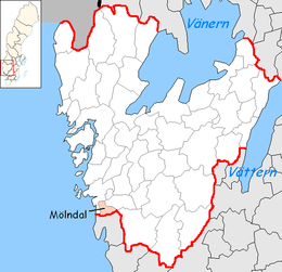
Mölndal Municipality
| Mölndal Municipality Mölndals kommun | ||
|---|---|---|
| Municipality | ||
| ||
 | ||
| Country | Sweden | |
| County | Västra Götaland County | |
| Seat | Mölndal | |
| Area[1] | ||
| • Total | 152.28 km2 (58.80 sq mi) | |
| • Land | 145.84 km2 (56.31 sq mi) | |
| • Water | 6.44 km2 (2.49 sq mi) | |
| Area as of 1 January 2014. | ||
| Population (March 31, 2018) | ||
| • Total | 66,733 | |
| • Density | 440/km2 (1,100/sq mi) | |
| Time zone | UTC+1 (CET) | |
| • Summer (DST) | UTC+2 (CEST) | |
| ISO 3166 code | SE | |
| Province | Västergötland and Halland | |
| Municipal code | 1481 | |
| Website | www.molndal.se | |
| Density is calculated using land area only. | ||

Mölndal Municipality (Mölndals kommun or Mölndals stad) is a municipality in Västra Götaland in western Sweden, just south of Gothenburg. Its seat is located in Mölndal, which lies within the Gothenburg urban area, and the whole municipality is part of Metropolitan Gothenburg.
In 1911 a municipalsamhälle (a kind of borough within a rural municipality, handling matters of urban character) named Mölndal was instituted in the municipality of Fässberg. In 1922 Fässberg was made the City of Mölndal. In 1971 it was amalgamated with Kållered and Lindome (the latter transferred from Halland County). At the same time it became a municipality of unitary type, like all others in the country. The municipality prefers, however, to style itself Mölndals stad (City of Mölndal) as a semi-official name whenever legally possible. This usage has no effect on the status of the municipality.
Population figures
The municipality has four main parts: Mölndal, Kållered, Lindome and Hällesåker.
- Mölndal has 37,131 inhabitants (a part of the contiguous Gothenburg urban area)
- Kållered has 7,257 inhabitants
- Lindome has 13,364 inhabitants
- Hällesåker has 900 inhabitants
Numbers from 2003.
Notable residents
- Lars Leksell (1907–1986), physician and neurosurgeon
Affiliations
Mölndal Municipality is twinned with the following towns:

Sights of interest
- Gunnebo House from the 18th century.
- Fässberg Church from the 19th century
See also
References
- ↑ "Statistiska centralbyrån, Kommunarealer den 1 januari 2014" (Microsoft Excel) (in Swedish). Statistics Sweden. Retrieved 2014-04-18.
External links
- Mölndal Municipality – Official site
- (in Swedish) Article Mölndal – From Nordisk Familjebok