Clearview, Ontario
| Clearview | |
|---|---|
| Township (lower-tier) | |
| Township of Clearview | |
|
| |
| Motto(s): Beautiful Landscapes, Friendly People | |
 Clearview Location of Clearview in southern Ontario | |
| Coordinates: 44°23′53″N 80°04′27″W / 44.39806°N 80.07417°WCoordinates: 44°23′53″N 80°04′27″W / 44.39806°N 80.07417°W[1] | |
| Country |
|
| Province |
|
| County | Simcoe |
| Established | January 1, 1994 |
| Government | |
| • Mayor | Christopher Vanderkruys |
| • MPs | Kellie Leitch (C) |
| • MPPs | Jim Wilson (PC) |
| Area[2] | |
| • Land | 557.10 km2 (215.10 sq mi) |
| Elevation[3] | 221 m (725 ft) |
| Population (2016)[2] | |
| • Total | 14,151 |
| • Density | 25.4/km2 (66/sq mi) |
| Time zone | UTC-5 (Eastern Time Zone (EST)) |
| • Summer (DST) | UTC-4 (Eastern Time Zone (EDT)) |
| Postal code FSA | L0M |
| Area code(s) | 705, 249 |
| Website |
www |
Clearview is an incorporated township in Simcoe County in Central Ontario, Canada,[1] west of Barrie and south of Collingwood and Wasaga Beach in Simcoe County.
History
Clearview Township was established on January 1, 1994, when the Town of Stayner, the Village of Creemore and the Townships of Nottawasaga and Sunnidale were amalgamated.[4] The Townships of Nottawasaga and Sunnidale were incorporated in 1851[5] and 1858,[6] respectively.
Early settlement on the site of Stayner coincided with the construction of a railway line from Toronto to Collingwood, Ontario between 1851 and 1855. The community of Stayner, which was originally called Nottawasaga Station, developed into a significant agricultural and lumbering centre.[7] Stayner was incorporated as a village in 1872,[8] and as a Town in 1888.[9] The Village of Creemore was incorporated effective 20 November 1889.[10]
Geography and climate
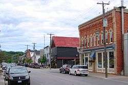
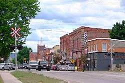
The township comprises the communities of Avening, Batteaux, Brentwood, Cashtown Corners, Creemore, Dunedin, Duntroon, Glen Huron, Maple Valley, New Lowell, Nottawa, Pretty River Valley, Smithdale, Stayner, Sunnidale, Sunnidale Corners and Websterville.
It borders on the following municipalities:
- North Collingwood, Wasaga Beach
- East Springwater, Essa
- South Adjala-Tosorontio, Mulmur, Melancthon
- West Grey Highlands, The Blue Mountains
Clearview (and Simcoe County in general) is part of Central Ontario as well as the Georgian Triangle. The climate in the area is classified as Humid Continental (Warm Summer Subtype).
Located in the Great Lakes lowlands, it has fertile soil quite suitable for farming. As a result of the proximity to the Great Lakes it suffers from Lake Effect.
Economy
As of 2006, compared to Ontario as a whole, Construction, Agriculture, and Manufacturing industries employ a greater than average percentage of the workforce (Business, Finance and Real Estate employ smaller than average).[11] The employment rate was 67.1% (62.8% for Ontario) and the unemployment rate was 4.5% (6.4% for Ontario). 40% of the workforce worked outside the municipality and 13% worked from home.
The well-known Creemore Springs Brewery is located in Creemore.
Health Canada medical marijuana licensed producer The Peace Naturals Project produces their medicinal Cannabis in Clearview Township.
The Stayner Sun is the township's newspaper of record. It has published continually since 1877. The newspaper is owned by Metroland Media Group.
Demographics
| Canada census – Clearview, Ontario community profile | |||
|---|---|---|---|
| 2011 | 2006 | ||
| Population: | 13,734 (-2.5% from 2006) | 14,088 (2.1% from 2001) | |
| Land area: | 557.44 km2 (215.23 sq mi) | 557.32 km2 (215.18 sq mi) | |
| Population density: | 24.6/km2 (64/sq mi) | 25.3/km2 (66/sq mi) | |
| Median age: | 41.2 (M: 40.8, F: 41.6) | ||
| Total private dwellings: | 5852 | 5814 | |
| Median household income: | $61,518 | ||
| References: 2011[12] 2006[13] earlier[14] | |||
Government
The township is administered by a Town Council with one member from each of the seven (numbered) wards, a Mayor and Deputy-mayor.
The administration of the town is divided into the Departments of Finance, Planning and Development, Public Works, an Administration staff as well as the Public Library and Fire Department.[15] All the main administrative buildings of Clearview are located in Stayner.
The 2010 budget for the township is $17,470,379.[16]
Education
Clearview township is served by the Simcoe County District School Board (SCDSB), Simcoe Muskoka Catholic District School Board (SMCDS) and the French Catholic School Board Conseil scolaire de district catholique Centre-Sud. A number of schools, although located in other municipalities (specifically Collingwood and Wasaga Beach), have catchment areas that extend into Clearview.
| Name | Type | Location | Board | Municipality |
|---|---|---|---|---|
| Byng Public School | Primary | Stayner | SCDSB | Clearview |
| Clearview Meadows Elementary School | Primary | Stayner | SCDSB | Clearview |
| Duntroon Central Public School | Primary | Duntroon | SCDSB | Clearview |
| New Lowell Central Public School | Primary | New Lowell | SCDSB | Clearview |
| Our Lady of the Assumption School | Primary | New Lowell | SMCDS | Clearview |
| Nottawa Elementary School | Primary | Nottawa | SCDSB | Clearview |
| Nottawasaga & Creemore Public School | Primary | Creemore | SCDSB | Clearview |
| St. Mary's School | Primary | Collingwood | SMCDS | Collingwood |
| St. Noel Chabanel | Primary | Wasaga Beach | SMCDS | Wasaga Beach |
| Stayner Collegiate Institute | Secondary | Stayner | SCDSB | Clearview |
| Collingwood Collegiate Institute | Secondary | Collingwood | SCDSB | Collingwood |
| Jean Vanier High School | Secondary | Collingwood | SMCDS | Collingwood |
While there is no post-secondary education in Clearview itself, the main campus of Georgian College is in nearby Barrie with a satellite campus in Collingwood nearby.
The Clearview Public Library maintains branches in Stayner, Creemore and New Lowell.
Infrastructure
Major roads in Clearview include Highway 26, County Road 124, (formerly Highway 24, and a part of Hurontario Street), County Road 42 (formerly a part of Airport Road), as well as other county roads such as 7, 9, 10, and 91. Despite its name, Collingwood Airport is also located in Clearview.
Clearview is served by Collingwood General And Marine Hospital in Collingwood. Policing services are provided by the Huronia West detachment of the OPP out of Wasaga Beach. Fire protection is provided by volunteer fire stations located throughout the township.[17]
There are two arenas (Stayner, Creemore), 3 Baseball Parks (Nottawa, Stayner, with the largest being in New Lowell) and 2 Golf Courses (Duntroon Highlands, Batteaux Creek Golf Club) in Clearview. Devil's Glen Provincial Park and Carruther's Memorial Conservation Area as well as the Mel McKean Memorial Park, Gowan Memorial Park, Ives Park, Kinsmen Participark, and Legion Park are also located there. There is also a small conservation area with a large pond in the village of New Lowell.
Notable attractions
- Creemore was one of the original claimants for the location of Ontario's smallest jailhouse. Its jailhouse, with dimensions at 4.5 metres by 6 metres, make it smaller than the other early claimants, Tweed, Ontario and Coboconk; however, others in Rodney, Ontario, Port Dalhousie, Ontario, Providence Bay, Ontario and Berens River are smaller. Today, the jail has been converted into a museum.
- The Great Northern Exhibition is held annually in Clearview Township.
See also
References
- 1 2 "Clearview". Geographical Names Data Base. Natural Resources Canada. Retrieved 2014-05-20.
- 1 2 "Clearview census profile". 2011 Census of Population. Statistics Canada. Retrieved 2012-03-07.
- ↑ Elevation taken from Google Earth at geographical coordinates, accessed 2014-05-20.
- ↑ "Welcome to Clearview Township". Retrieved 2010-11-28.
- ↑ Simcoe County By-Law No. 8; 31 August 1850
- ↑ Simcoe County By-Law No. 79, 23 June 1858
- ↑ "Archived copy". Archived from the original on 2012-04-03. Retrieved 2011-03-10. Ontario Heritage Trust Founding of Stayner
- ↑ Simcoe County By-Law No. 211, 26 June 1872
- ↑ 51 Victoria [1888] Chapter 61
- ↑ Simcoe County By-Law No. 466
- ↑ "2006 Community Profiles - Community highlights for Clearview". 2006 Census data. Statistics Canada. Retrieved 2010-12-15.
- ↑ "2011 Community Profiles". Canada 2011 Census. Statistics Canada. July 5, 2013. Retrieved 2012-03-07.
- ↑ "2006 Community Profiles". Canada 2006 Census. Statistics Canada. March 30, 2011. Retrieved 2012-03-07.
- ↑ "2001 Community Profiles". Canada 2001 Census. Statistics Canada. February 17, 2012.
- ↑ "Town Hall - Staff". Retrieved 2008-06-13.
- ↑ "2010 Expenditures" (PDF). Retrieved 2010-11-28.
- ↑ "Clearview Township - Fire - Stations". Retrieved 2010-11-28.
External links
| Wikimedia Commons has media related to Clearview, Ontario. |
Places adjacent to Clearview, Ontario | |
|---|---|