Creemore
| Creemore | |
|---|---|
 | |
 Creemore Location of Creemore, Ontario | |
| Coordinates: 44°19′N 80°06′W / 44.317°N 80.100°W | |
| Country |
|
| Province |
|
| County | Simcoe |
| Municipality | Clearview |
| Government | |
| • Mayor | Christopher Vanderkruys |
| • MP | Kellie Leitch |
| • MPP | Jim Wilson |
| Area[1] | |
| • Total | 1.58 km2 (0.61 sq mi) |
| Population (2016)[1] | |
| • Total | 1,170 |
| • Density | 739.8/km2 (1,916/sq mi) |
| Time zone | UTC-5 (Eastern (EST)) |
| • Summer (DST) | UTC-4 (EDT) |
| Postal code | L0M |
| Website | www.ourcreemore.com |
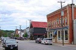
Creemore (from Irish Croí Mór, meaning 'big heart') is a former village, now part of Clearview Township, located in Simcoe County, Ontario, Canada. It lies approximately 130 kilometres (81 mi) north of Toronto, 40 minutes west of Barrie, and 20 minutes south of Collingwood and Georgian Bay. It sits on the eastern boundary of the Niagara Escarpment.[2]
Creemore purportedly has North America's smallest jail. Coboconk and Tweed make similar claims of their jails.
History
The settlement of Creemore began in 1842 and by the turn of the century it was a thriving village of about 800 people with a vibrant business community.
In 1993, the amalgamation of Sunnidale, Nottawasaga, Village of Creemore and Town of Stayner took place and it became Clearview Township.
According to the 2016 Census, the village of Creemore had 1,170 people.[1]
Economy
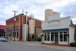
Creemore has a vibrant small business community and is the home to Creemore Springs Brewery. The microbrewery was acquired by Molson on April 22, 2005. Each year the Copper Kettle festival attracts thousands, closing the entire main street with activities and antique automobile displays, bands, Farm animals and many other attractions for young and old.
With its trendy boutiques and a large Legion hall, where auctions are frequently held, Creemore is a popular stop for Torontonians looking for a fun getaway. The local pub is also a busy place on weekends attracting thousands of Motorcyclists during the summer and snowmobilers in the winter.
References
- 1 2 3 "Census Profile". 2016 Census. Statistics Canada.
- ↑ "About Us". Retrieved 2010-03-10.
External links
Coordinates: 44°19′N 80°06′W / 44.317°N 80.100°W