State Road 118 (Serbia)
| ||||
|---|---|---|---|---|
|
Државни пут IIА реда 118 Državni put IIA reda 118 | ||||
 | ||||
| Route information | ||||
| Maintained by JP "Putevi Srbije" | ||||
| Length | 18.387 km (11.425 mi) | |||
| Major junctions | ||||
| From |
Žitište | |||
| To |
Srpski Itebej | |||
| Location | ||||
| Districts | Central Banat | |||
| Highway system | ||||
| ||||

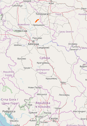
State Road 118, is an IIA-class road in northern Serbia, connecting Žitište with Srpski Itebej. It is located in Vojvodina.[1]
Before the new road categorization regulation given in 2013, the route wore the following names: P 123.1 and P 123 (before 2012) / 113 and 109 (after 2012).[2][3]
The existing route is a regional road with two traffic lanes. By the valid Space Plan of Republic of Serbia the road is not planned for upgrading to main road, and is expected to be conditioned in its current state.[4]
Sections
| Section number | Length | Distance | Section name |
|---|---|---|---|
| 11801 | 6.132 km (3.810 mi) | 6.132 km (3.810 mi) | Žitište – Torak |
| 11802 | 12.255 km (7.615 mi) | 18.387 km (11.425 mi) | Torak – Srpski Itebej |
See also
References
- ↑ "Republic of Serbia – national road network" (PDF). Putevi Srbije (in Serbian).
- ↑ "National road categorization regulation – Official Gazette of Republic of Serbia no. 105/2013 and 119/2013" (PDF). Serbian Spatial Planners Association (in Serbian).
- ↑ "Link between actual and previous section and road markings" (PDF). Putevi Srbije (in Serbian).
- ↑ Space plan of Republic of Serbia from 2010 to 2021
External links
This article is issued from
Wikipedia.
The text is licensed under Creative Commons - Attribution - Sharealike.
Additional terms may apply for the media files.