State Park, South Carolina
| State Park, South Carolina | |
|---|---|
| Unincorporated community | |
 State Park  State Park | |
| Coordinates: 34°05′27″N 80°57′58″W / 34.09083°N 80.96611°WCoordinates: 34°05′27″N 80°57′58″W / 34.09083°N 80.96611°W | |
| Country | United States |
| State | South Carolina |
| County | Richland |
| Elevation | 364 ft (111 m) |
| Time zone | UTC-5 (Eastern (EST)) |
| • Summer (DST) | UTC-4 (EDT) |
| ZIP code | 29147 |
| Area code(s) | 803 |
| GNIS feature ID | 1231825[1] |
State Park is an unincorporated community in Richland County, South Carolina, United States.[1] The community is located in a suburban area 7.3 miles (11.7 km) northeast of Columbia. State Park has a post office with ZIP code 29147.[2][3]
References
- 1 2 "State Park". Geographic Names Information System. United States Geological Survey.
- ↑ United States Postal Service. "USPS - Look Up a ZIP Code". Retrieved October 23, 2016.
- ↑ "Postmaster Finder - Post Offices by ZIP Code". United States Postal Service. Retrieved October 23, 2016.
Municipalities and communities of Richland County, South Carolina, United States | ||
|---|---|---|
| Cities | 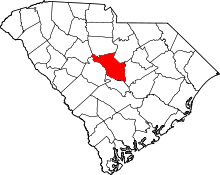 | |
| Towns | ||
| CDPs | ||
| Unincorporated communities | ||
| Footnotes | ‡This populated place also has portions in an adjacent county or counties | |
This article is issued from
Wikipedia.
The text is licensed under Creative Commons - Attribution - Sharealike.
Additional terms may apply for the media files.