Saint-Galmier
| Saint-Galmier | ||
|---|---|---|
| Commune | ||
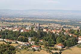 A general view of Saint-Galmier | ||
| ||
 Saint-Galmier Location within Auvergne-Rhône-Alpes region  Saint-Galmier | ||
| Coordinates: 45°35′27″N 4°19′05″E / 45.5908°N 4.3181°ECoordinates: 45°35′27″N 4°19′05″E / 45.5908°N 4.3181°E | ||
| Country | France | |
| Region | Auvergne-Rhône-Alpes | |
| Department | Loire | |
| Arrondissement | Montbrison | |
| Canton | Andrézieux-Bouthéon | |
| Intercommunality | Saint-Étienne Métropole | |
| Government | ||
| • Mayor (2001–2008) | Jean-Pierre Bouchardon | |
| Area1 | 19.47 km2 (7.52 sq mi) | |
| Population (1999)2 | 5,293 | |
| • Density | 270/km2 (700/sq mi) | |
| Time zone | UTC+1 (CET) | |
| • Summer (DST) | UTC+2 (CEST) | |
| INSEE/Postal code | 42222 /42330 | |
| Elevation |
357–551 m (1,171–1,808 ft) (avg. 480 m or 1,570 ft) | |
|
1 French Land Register data, which excludes lakes, ponds, glaciers > 1 km2 (0.386 sq mi or 247 acres) and river estuaries. 2 Population without double counting: residents of multiple communes (e.g., students and military personnel) only counted once. | ||

Saint-Galmier is a commune in the Loire department in central France.
Its residents are called Baldomériens.
Water
Saint Galmier is a spa town and the source of Badoit mineral water. The thermal spring was known of in Gallo-Roman times, but its fame increased with the general growth in interest in thermal cures in Europe during the nineteenth century.
Before Auguste Badoit appeared on the scene and commercialised the water in the 1830s, both the water, and the spring from which it emerged, were known as "Fontfort". It is for this reason that briefly, during the French Revolutionary period, the town was known as "Fontfortville".
People
- Gilbert Bostsarron, a member of the French Resistance was born here.
- Roger Rivière, a professional cyclist, who was born in Saint-Etienne in 1936, died here in 1976.
See also
References
| Wikimedia Commons has media related to Saint-Galmier. |
| Authority control |
|---|