Sauvain
| Sauvain | |
|---|---|
| Commune | |
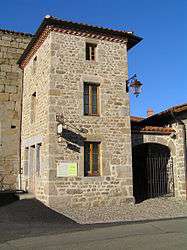 The museum in Sauvain | |
 Sauvain Location within Auvergne-Rhône-Alpes region  Sauvain | |
| Coordinates: 45°40′27″N 3°54′23″E / 45.6742°N 3.9064°ECoordinates: 45°40′27″N 3°54′23″E / 45.6742°N 3.9064°E | |
| Country | France |
| Region | Auvergne-Rhône-Alpes |
| Department | Loire |
| Arrondissement | Montbrison |
| Canton | Boën-sur-Lignon |
| Intercommunality | Communauté d'agglomération Loire Forez |
| Government | |
| • Mayor | Henri Goutte |
| Area1 | 30.23 km2 (11.67 sq mi) |
| Population (1999)2 | 429 |
| • Density | 14/km2 (37/sq mi) |
| Time zone | UTC+1 (CET) |
| • Summer (DST) | UTC+2 (CEST) |
| INSEE/Postal code | 42298 /42990 |
| Elevation |
640–1,631 m (2,100–5,351 ft) (avg. 890 m or 2,920 ft) |
|
1 French Land Register data, which excludes lakes, ponds, glaciers > 1 km2 (0.386 sq mi or 247 acres) and river estuaries. 2 Population without double counting: residents of multiple communes (e.g., students and military personnel) only counted once. | |
Sauvain is a commune in the Loire department in central France.
Geography
The river Lignon du Forez flows through the commune.
See also
| Wikimedia Commons has media related to Sauvain. |
This article is issued from
Wikipedia.
The text is licensed under Creative Commons - Attribution - Sharealike.
Additional terms may apply for the media files.