Châteauneuf, Loire
| Châteauneuf | |
|---|---|
| Commune | |
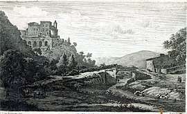 The château in 1789 | |
 Châteauneuf Location within Auvergne-Rhône-Alpes region  Châteauneuf | |
| Coordinates: 45°31′22″N 4°37′32″E / 45.5228°N 4.6256°ECoordinates: 45°31′22″N 4°37′32″E / 45.5228°N 4.6256°E | |
| Country | France |
| Region | Auvergne-Rhône-Alpes |
| Department | Loire |
| Arrondissement | Saint-Étienne |
| Canton | Rive-de-Gier |
| Intercommunality | Saint-Étienne Métropole |
| Government | |
| • Mayor (2008–2014) | Bernard Laget |
| Area1 | 13.65 km2 (5.27 sq mi) |
| Population (1999)2 | 1,445 |
| • Density | 110/km2 (270/sq mi) |
| Time zone | UTC+1 (CET) |
| • Summer (DST) | UTC+2 (CEST) |
| INSEE/Postal code | 42053 /42800 |
| Elevation |
208–657 m (682–2,156 ft) (avg. 230 m or 750 ft) |
|
1 French Land Register data, which excludes lakes, ponds, glaciers > 1 km2 (0.386 sq mi or 247 acres) and river estuaries. 2 Population without double counting: residents of multiple communes (e.g., students and military personnel) only counted once. | |
Châteauneuf is a commune in the Loire department in central France.
See also
| Wikimedia Commons has media related to Châteauneuf (Loire). |
This article is issued from
Wikipedia.
The text is licensed under Creative Commons - Attribution - Sharealike.
Additional terms may apply for the media files.