Roche-la-Molière
| Roche-la-Molière | ||
|---|---|---|
| Commune | ||
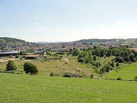 A general view of Roche-la-Molière | ||
| ||
 Roche-la-Molière Location within Auvergne-Rhône-Alpes region  Roche-la-Molière | ||
| Coordinates: 45°26′05″N 4°19′28″E / 45.4347°N 4.3244°ECoordinates: 45°26′05″N 4°19′28″E / 45.4347°N 4.3244°E | ||
| Country | France | |
| Region | Auvergne-Rhône-Alpes | |
| Department | Loire | |
| Arrondissement | Saint-Étienne | |
| Canton | Saint-Étienne-3 | |
| Intercommunality | Saint-Étienne Métropole | |
| Government | ||
| • Mayor (2008–2014) | Marie-Hélène Sauzéa | |
| Area1 | 17.44 km2 (6.73 sq mi) | |
| Population (2006)2 | 10,365 | |
| • Density | 590/km2 (1,500/sq mi) | |
| Demonym(s) | Rouchonnes, Rouchons | |
| Time zone | UTC+1 (CET) | |
| • Summer (DST) | UTC+2 (CEST) | |
| INSEE/Postal code | 42189 /42230 | |
| Elevation | 469–700 m (1,539–2,297 ft) | |
| Website | http://www.rochelamoliere.com/ | |
|
1 French Land Register data, which excludes lakes, ponds, glaciers > 1 km2 (0.386 sq mi or 247 acres) and river estuaries. 2 Population without double counting: residents of multiple communes (e.g., students and military personnel) only counted once. | ||
.svg.png)
Roche-la-Molière is a commune in the Loire department in the Auvergne-Rhône-Alpes region in central France.
See also
| Wikimedia Commons has media related to Roche-la-Molière. |
This article is issued from
Wikipedia.
The text is licensed under Creative Commons - Attribution - Sharealike.
Additional terms may apply for the media files.