Andrézieux-Bouthéon
| Andrézieux-Bouthéon | ||
|---|---|---|
| Commune | ||
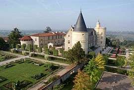 The château of Bouthéon | ||
| ||
 Andrézieux-Bouthéon Location within Auvergne-Rhône-Alpes region  Andrézieux-Bouthéon | ||
| Coordinates: 45°31′37″N 4°15′39″E / 45.5269°N 4.2608°ECoordinates: 45°31′37″N 4°15′39″E / 45.5269°N 4.2608°E | ||
| Country | France | |
| Region | Auvergne-Rhône-Alpes | |
| Department | Loire | |
| Arrondissement | Saint-Étienne | |
| Canton | Andrézieux-Bouthéon | |
| Intercommunality | Saint-Étienne Métropole | |
| Government | ||
| • Mayor (2014-2020) | Jean-Claude Schalk | |
| Area1 | 16.28 km2 (6.29 sq mi) | |
| Population (2014)2 | 9,876 | |
| • Density | 610/km2 (1,600/sq mi) | |
| Time zone | UTC+1 (CET) | |
| • Summer (DST) | UTC+2 (CEST) | |
| INSEE/Postal code | 42005 /42160 | |
| Elevation |
353–435 m (1,158–1,427 ft) (avg. 367 m or 1,204 ft) | |
|
1 French Land Register data, which excludes lakes, ponds, glaciers > 1 km2 (0.386 sq mi or 247 acres) and river estuaries. 2 Population without double counting: residents of multiple communes (e.g., students and military personnel) only counted once. | ||
.svg.png)
Andrézieux-Bouthéon (Arpitan: Andrèsiô-Botion) is a commune of the Loire department in central France.
Population
| Historical population | ||
|---|---|---|
| Year | Pop. | ±% |
| 1962 | 3,531 | — |
| 1968 | 3,952 | +11.9% |
| 1975 | 7,640 | +93.3% |
| 1982 | 8,877 | +16.2% |
| 1990 | 9,407 | +6.0% |
| 1999 | 9,153 | −2.7% |
| 2006 | 9,508 | +3.9% |
| 2009 | 9,675 | +1.8% |
Sights
- Le Château Bouthéon
International Relations
Andrézieux is twinned with:
See also
References
| Wikimedia Commons has media related to Andrézieux-Bouthéon. |
This article is issued from
Wikipedia.
The text is licensed under Creative Commons - Attribution - Sharealike.
Additional terms may apply for the media files.