St Faith's and Aylsham Rural District
 Boundaries in 1894. St Faith's RD in red, Aylsham RD yellow. |
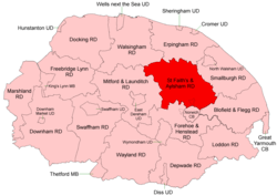 Boundaries in 1935 |
St Faith's and Aylsham Rural Districts were adjacent rural districts in Norfolk, England from 1894 to 1935.[1][2]
They were formed under the Local Government Act 1894 based on rural sanitary districts of the same names, and lay to the north of Norwich.
In 1935 some northern parts of Aylsham RD were variously transferred to Walsingham, Erpingham and Smallburgh RDs. The remainder, and the whole of St Faith's RD, were merged to form St Faith's and Aylsham Rural District.[3] Changes to the border with Norwich County Borough were made in 1907, 1951 and 1968.
In 1974, the merged district was abolished under the Local Government Act 1972, and became part of the Broadland district.
Statistics
| Year | St Faith's RD | Aylsham RD | ||||
|---|---|---|---|---|---|---|
| Area (ha) [4] |
Population [5] |
Density (pop/ha) |
Area (ha) [6] |
Population [7] |
Density (pop/ha) | |
| 1911 | 19,803 | 10,807 | 0.55 | 28,062 | 17,344 | 0.62 |
| 1921 | 10,917 | 0.55 | 16,345 | 0.58 | ||
| 1931 | 14,111 | 0.71 | 16,212 | 0.58 | ||
| St Faith's and Aylsham RD[8][9] | ||||||
| 1951 | 37,638 | 37,629 | 1.00 | |||
| 1961 | 46,003 | 1.22 | ||||
Parishes
These parishes operated within St Faith's and Aylsham RD unless otherwise indicated.
| Parish | From | To | Notes |
|---|---|---|---|
| Alby with Thwaite | 1935 | Aylsham RD. To Erpingham RD | |
| Alderford | St Faith's RD | ||
| Attlebridge | St Faith's RD | ||
| Aylsham | Aylsham RD | ||
| Banningham | 1935 | Aylsham RD. To Erpingham RD | |
| Beeston St Andrew | St Faith's RD | ||
| Belaugh | Aylsham RD | ||
| Blickling | Aylsham RD | ||
| Booton | St Faith's RD | ||
| Brampton | Aylsham RD | ||
| Brandiston | St Faith's RD | ||
| Burgh | 1935 | Aylsham RD. Added to Tuttington | |
| Buxton | 1935 | Aylsham RD. Component of Buxton with Lammas | |
| Buxton with Lammas | 1935 | Merger of Buxton and Lammas with Little Hautbois | |
| Calthorpe | 1935 | Aylsham RD. To Erpingham RD | |
| Catton | St Faith's RD | ||
| Cawston | Aylsham RD | ||
| Colby | 1935 | Aylsham RD. To Erpingham RD | |
| Coltishall | Aylsham RD | ||
| Corpusty | 1935 | Aylsham RD. To Erpingham RD | |
| Crostwick | St Faith's RD | ||
| Drayton | St Faith's RD | ||
| Erpingham | 1935 | Aylsham RD. To Erpingham RD | |
| Felthorpe | St Faith's RD | ||
| Foulsham | Aylsham RD | ||
| Frettenham | St Faith's RD | ||
| Great Hautbois | 1935 | Aylsham RD. Added to Coltishall | |
| Great Witchingham | St Faith's RD | ||
| Guestwick | Aylsham RD | ||
| Hackford | 1935 | Aylsham RD. Component of Reepham | |
| Hainford | St Faith's RD | ||
| Haveringland | St Faith's RD | ||
| Hellesdon | St Faith's RD | ||
| Hevingham | 1935 | Aylsham RD. Added to Reepham | |
| Heydon | Aylsham RD | ||
| Hindolveston | 1935 | Aylsham RD. To Walsingham RD | |
| Honingham | St Faith's RD | ||
| Horsford | St Faith's RD | ||
| Horsham St Faith and Newton St Faith | St Faith's RD | ||
| Horstead with Stanninghall | St Faith's RD | ||
| Ingworth | 1935 | Aylsham RD. To Erpingham RD | |
| Itteringham | 1935 | Aylsham RD. To Erpingham RD | |
| Lammas with Little Hautbois | 1935 | Aylsham RD. Component of Buxton with Lammas | |
| Little Barningham | 1935 | Aylsham RD. To Erpingham RD | |
| Little Witchingham | St Faith's RD | ||
| Mannington | 1935 | Aylsham RD. To Erpingham RD | |
| Marsham | Aylsham RD | ||
| Morton on the Hill | St Faith's RD | ||
| Oulton | Aylsham RD | ||
| Oxnead | 1935 | Aylsham RD. Added to Brampton | |
| Rackheath | St Faith's RD | ||
| Reepham | 1935 | Merger of Reepham with Kerdiston, Whitwell and Hackford | |
| Reepham with Kerdiston | 1935 | Aylsham RD. Component of Reepham | |
| Ringland | St Faith's RD | ||
| Salhouse | St Faith's RD | ||
| Salle | Aylsham RD | ||
| Saxthorpe | 1935 | Aylsham RD. To Erpingham RD | |
| Scottow | 1935 | Aylsham RD. To Smallburgh RD | |
| Skeyton | 1935 | Aylsham RD. To Smallburgh RD | |
| Spixworth | St Faith's RD | ||
| Sprowston | St Faith's RD | ||
| Stratton Strawless | Aylsham RD | ||
| Swannington | St Faith's RD | ||
| Swanton Abbott | 1935 | Aylsham RD. To Smallburgh RD | |
| Taverham | St Faith's RD | ||
| Themelthorpe | Aylsham RD | ||
| Thurning | 1935 | Aylsham RD. To Walsingham RD | |
| Tuttington | Aylsham RD | ||
| Weston Longville | St Faith's RD | ||
| Whitwell | 1935 | Aylsham RD. Component of Reepham | |
| Wickmere | 1935 | Aylsham RD. To Erpingham RD | |
| Wolterton | Aylsham RD. To Erpingham RD | ||
| Wood Dalling | Aylsham RD | ||
| Wood Norton | 1935 | Aylsham RD. To Walsingham RD | |
| Wroxham | St Faith's RD |
References
- ↑ "St Faiths RD through time: Census tables with data for the Local Government District". A Vision of Britain through Time. GB Historical GIS / University of Portsmouth. Retrieved 1 July 2017.
- ↑ "Aylsham RD through time: Census tables with data for the Local Government District". A Vision of Britain through Time. GB Historical GIS / University of Portsmouth. The parish list here includes Hemblington, evidently a mistake – it belongs in Blofield RD. Retrieved 1 July 2017.
- ↑ "St Faiths and Aylsham RD through time: Census tables with data for the Local Government District". A Vision of Britain through Time. GB Historical GIS / University of Portsmouth. Retrieved 1 July 2017.
- ↑ "St Faiths RD through time: Population Statistics: Area (acres)". A Vision of Britain through Time. GB Historical GIS / University of Portsmouth. Retrieved 1 Jul 2017.
- ↑ "St Faiths RD through time: Population Statistics: Total Population". A Vision of Britain through Time. GB Historical GIS / University of Portsmouth. Retrieved 1 Jul 2017.
- ↑ "Aylsham RD through time: Population Statistics: Area (acres)". A Vision of Britain through Time. GB Historical GIS / University of Portsmouth. Retrieved 1 Jul 2017.
- ↑ "Aylsham RD through time: Population Statistics: Total Population". A Vision of Britain through Time. GB Historical GIS / University of Portsmouth. Retrieved 1 Jul 2017.
- ↑ "St Faiths and Aylsham RD through time: Population Statistics: Area (acres)". A Vision of Britain through Time. GB Historical GIS / University of Portsmouth. Retrieved 1 Jul 2017.
- ↑ "St Faiths and Aylsham RD through time: Population Statistics: Total Population". A Vision of Britain through Time. GB Historical GIS / University of Portsmouth. Retrieved 1 Jul 2017.