Themelthorpe
| Themelthorpe | |
|---|---|
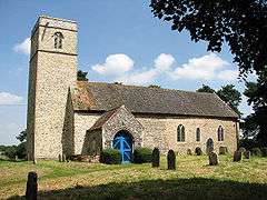 St Andrew's church, Themelthorpe | |
 Themelthorpe Themelthorpe shown within Norfolk | |
| Area | 2.69 km2 (1.04 sq mi) |
| Population | 65 |
| • Density | 24/km2 (62/sq mi) |
| OS grid reference | TG055238 |
| Civil parish |
|
| District | |
| Shire county | |
| Region | |
| Country | England |
| Sovereign state | United Kingdom |
| Post town | DEREHAM |
| Postcode district | NR20 |
| Police | Norfolk |
| Fire | Norfolk |
| Ambulance | East of England |
| EU Parliament | East of England |
Themelthorpe is a civil parish in the English county of Norfolk, 3 miles (4.8 km) north west of Reepham. It covers an area of 2.69 km2 (1.04 sq mi) and had a population of 65 in 27 households at the 2001 census.[1] For the purposes of local government, it falls within the district of Broadland.
Themelthorpe Curve
The Themelthorpe Curve was built to join two separate stretches of railway, the section from Themelthorpe to Norwich which built in 1882 by the Midland and Great Northern Joint Railway and the line from Themelthorpe to Aylsham, completed in 1883 by the Great Eastern Railway. This section was to be the final section of railway track built in Norfolk by British Rail and was the sharpest curve in the whole of the British rail network.[2] It was opened in 1960 to shorten the route of freight trains carrying concrete products running from a terminal at Lenwade, and was closed by 1985. It is now part of the Marriott's Way footpath.
Notes
- ↑ Census population and household counts for unparished urban areas and all parishes Archived 2017-02-11 at the Wayback Machine.. Office for National Statistics & Norfolk County Council (2001). Retrieved 20 June 2009.
- ↑ "The Marriott's Way". Guardian Newspapers. 3 March 2007. Retrieved 22 June 2009.
External links
![]()