Smallburgh Rural District
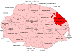 Boundaries in 1894. |
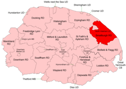 Boundaries in 1935 |
Smallburgh Rural District was a rural district in Norfolk, England from 1894 to 1974.[1]
It was formed under the Local Government Act 1894 based on the Smallburgh rural sanitary district. Lying to the south-east of North Walsham it originally had two small areas detached from it main body.
In 1935 it took in parts of Aylsham and Erpingham RDs, thus joining up into a single extent.
In 1974, the district was abolished under the Local Government Act 1972, and became part of the North Norfolk district.
Statistics
| Year | Area (ha) [2] |
Population [3] |
Density (pop/ha) |
|---|---|---|---|
| 1911 | 25,345 | 13,424 | 0.53 |
| 1921 | 13,905 | 0.55 | |
| 1931 | 13,986 | 0.55 | |
| 1951 | 28,335 | 18,429 | 0.65 |
| 1961 | 17,376 | 0.61 |
Parishes
| Parish | From | To | Notes |
|---|---|---|---|
| Ashmanhaugh | |||
| Bacton | |||
| Barton Turf | |||
| Beeston St Lawrence | 1935 | Added to Ashmanhaugh | |
| Bradfield | 1935 | Added to Swafield | |
| Brumstead | |||
| Catfield | |||
| Crostwight | 1935 | Added to Honing | |
| Dilham | |||
| East Ruston | |||
| Edingthorpe | 1935 | Added to Bacton | |
| Felmingham | |||
| Happisburgh | |||
| Hempstead with Eccles | 1935 | Added to Lessingham | |
| Hickling | |||
| Honing | |||
| Horning | |||
| Horsey | |||
| Hoveton | 1935 | Merger of 2 following parishes | |
| Hoveton St John | 1935 | ||
| Hoveton St Peter | 1935 | ||
| Ingham | |||
| Irstead | |||
| Knapton | Formerly Erpingham RD. From 1935-1950 included in Paston | ||
| Lessingham | |||
| Ludham | |||
| Neatishead | |||
| Palling | |||
| Paston | |||
| Potter Heigham | |||
| Ridlington | 1935 | Added to Witton | |
| Sco Ruston | 1935 | Added to Tunstead | |
| Scottow | 1935 | Formerly Aylsham RD | |
| Sea Palling | |||
| Skeyton | 1935 | Formerly Aylsham RD | |
| Sloley | |||
| Smallburgh | |||
| Stalham | |||
| Sutton | |||
| Swafield | |||
| Swanton Abbott | 1935 | Formerly Aylsham RD | |
| Trunch | 1935 | Formerly Erpingham RD | |
| Tunstead | |||
| Walcott | 1935 | Added to Happisburgh | |
| Waxham | 1935 | Added to Palling | |
| Westwick | |||
| Witton | |||
| Worstead |
References
- ↑ "Smallburgh RD through time: Census tables with data for the Local Government District". A Vision of Britain through Time. GB Historical GIS / University of Portsmouth. Retrieved 30 June 2017.
- ↑ "Smallburgh through time: Population Statistics: Area (acres)". A Vision of Britain through Time. GB Historical GIS / University of Portsmouth. Retrieved 30 Jun 2017.
- ↑ "Smallburgh through time: Population Statistics: Total Population". A Vision of Britain through Time. GB Historical GIS / University of Portsmouth. Retrieved 30 Jun 2017.
This article is issued from
Wikipedia.
The text is licensed under Creative Commons - Attribution - Sharealike.
Additional terms may apply for the media files.