St. George station
St. George | ||||||||||||||||
|---|---|---|---|---|---|---|---|---|---|---|---|---|---|---|---|---|
 | ||||||||||||||||
| Location |
139 St. George Street Toronto, Ontario Canada | |||||||||||||||
| Coordinates | 43°40′05″N 79°23′59″W / 43.66806°N 79.39972°WCoordinates: 43°40′05″N 79°23′59″W / 43.66806°N 79.39972°W | |||||||||||||||
| Platforms | Centre platform (Line 1 and Line 2) | |||||||||||||||
| Tracks | 4 (2 per line) | |||||||||||||||
| Connections |
| |||||||||||||||
| Construction | ||||||||||||||||
| Structure type | Underground | |||||||||||||||
| Platform levels | 2 | |||||||||||||||
| Disabled access | Yes | |||||||||||||||
| History | ||||||||||||||||
| Opened |
February 28, 1963 (Line 1) February 26, 1966 (Line 2) | |||||||||||||||
| Traffic | ||||||||||||||||
| Passengers (2016[1]) |
126,930 (Line 1) 132,380 (Line 2) 259,310 Total Ranked 2nd of 69 | |||||||||||||||
| Services | ||||||||||||||||
| ||||||||||||||||
St. George is a station on Line 1 Yonge–University and Line 2 Bloor–Danforth of the Toronto subway. It is located north of Bloor Street West between St. George Street and Bedford Road. This is the second-busiest station, after Bloor–Yonge station, serving a combined total of approximately 259,310 people a day. Wi-fi service is available at this station.[2]
Entrances
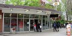

- The St. George Street entrance is a semi-automatic entrance which is staffed during peak hours (at times when there is no booth attendant available, entry here is by TTC pass or Presto card only). It is located on the east side of St. George Street just north of Bloor Street West at 43°40′05.75″N 79°23′59.6″W / 43.6682639°N 79.399889°W As of March 2018, Presto card readers were added to this entrance.[3]
- The Bedford entrance is located on the west side of Bedford Road just north of Bloor Street West at 43°40′07.25″N 79°23′52.4″W / 43.6686806°N 79.397889°W. Patrons board the 26 Dupont bus from a platform within the station boundaries at this entrance without the need for a paper transfer.[4] The Bedford entrance also has Presto card access.[5]
- There is also an underground entrance connected to Ontario Institute for Studies in Education, accepting only Presto cards and TTC passes.
History
The station was first opened on February 28, 1963, for the Yonge–University line, followed by the Bloor–Danforth line on February 26, 1966.
Between 1963 and 1966, there was a direct surface connection at the Bedford Road subway entrance to Bloor and Danforth streetcars. The "Bedford Loop" was immediately south of the station structure and had opened in 1954 to provide a short turn facility for westbound streetcars serving Bloor station on the new Yonge Subway. Streetcars entered from Bedford Road, turned west into the loop beside the station, and exited south on to Bloor Street. The platform was on the east side of what is now the Ontario Institute for Studies in Education, with a TTC transformer station constructed at the former entrance and the exit where the Bloor-Bedford Parkette is situated. This loop gave passengers travelling in peak hours a more direct connection between the subway and eastbound and westbound streetcars than walking to/from the curbside stops. The loop closed in February 1966 when streetcar routes were replaced by the Bloor-Danforth Subway.[6]
In 1999, this station became accessible with elevators.
Interlining
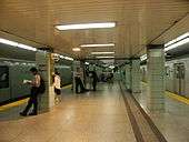
St. George and Bay stations are both two-level stations with two platforms, with Line 1 on the upper level, and Line 2 on the lower level at St. George. Between these stations and Museum is a full double-track, grade-separated wye junction. The tracks to and from Museum connect to the upper-level platforms at St. George and the lower-level platforms at Bay stations, while the tracks along Bloor use the lower level at St. George and the upper level at Bay. From February to September 1966, all three sides of the wye were used in regular service: from each of three termini—Eglinton, Keele, and Woodbine—trains ran alternately to the other two (between Eglinton and Museum they went via Union).
After the six months of interlining, the Bloor–Danforth Line became a separate route and the lower platforms at Bay (sometimes called Lower Bay) were closed. The upper-level platforms at St. George became the terminus of the Yonge–University line until 1978, when the extension to Wilson was opened. Lower Bay is sometimes used as a movie or TV set, and has been used for platform-surface experiments.
Paul Arthur signage

Some areas of the station contain wayfinding signage with the image of a crest with a dragon, referencing the Christian legend of St. George. However, St. George Street is actually named for Quetton St. George, a French-born British citizen who lived in Toronto in the 19th century. The signs were designed by Paul Arthur and installed in 1993 as part of a new system of wayfinding signage, which was to be implemented in the entire subway system.[7] Ultimately, the TTC did not go through with the project but did not remove the prototypes either, preserving some of Arthur's designs.
A further wayfinding project began implementation in 2014: using circles with the colour and number of each line to identify them more easily. Signage for that project rolled out at Bloor–Yonge station in March of that year, with St. George set to be the next to follow.[8][9]
Subway infrastructure in the vicinity
Both platforms lie on an east–west alignment, with the Line 1 platform being one of three platforms on that line with an east–west orientation, the others being Union and Downsview Park. Upon leaving the station, the line curves south by 90 degrees to run under Queen’s Park (the street). The two tracks split into separate tunnels in this area, briefly running at different levels to form a grade-separated junction with the second pair of link tracks from the Bloor–Danforth line, which curves in from the east.
Tenants
- Gateway Newstands (one at the St. George entrance/exit and another at the Bedford entrance/exit)
Nearby landmarks
Nearby landmarks include the Bata Shoe Museum, University of Toronto Schools, the north side of the University of Toronto, the Royal Conservatory of Music, the Chinese Consul General, the Royal Ontario Museum, and the York Club.
Surface connections
TTC routes serving the station include:
| Route | Name | Additional Information |
|---|---|---|
| 26 | Dupont | Westbound to Jane station |
References
- ↑ "Subway ridership, 2016" (PDF). Toronto Transit Commission. Retrieved July 3, 2018.
This table shows the typical number of customer-trips made on each subway on an average weekday and the typical number of customers travelling to and from each station platform on an average weekday.
- ↑ "Wi-fi Now Available At". TCONNECT. Archived from the original on February 20, 2015. Retrieved January 1, 2015.
Each of the 65 underground stations will have wireless and Wi-Fi service by 2017
- ↑
- ↑ TTC Ride Guide retrieved October 23, 2007 from http://www.toronto.ca/ttc/pdf/rideguide.pdf
- ↑ "TTC St George Station". TTC. Retrieved October 29, 2016.
- ↑ James Bow. "The Bloor Streetcar (Deceased)". Transit Toronto. Retrieved March 1, 2014.
- ↑ "TTC Signs". Joe Clark. June 9, 2006. Retrieved October 29, 2016.
- ↑ "New Wayfinding Standards" (PDF). Toronto Transit Commission. October 2013. Retrieved March 1, 2014.
Pilot study – Bloor-Yonge & St. George Stations
- ↑ Toronto Transit Commission. "New Subway Station Signage on the TTC". YouTube. Retrieved March 16, 2014.
External links
![]()