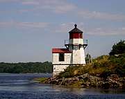
Squirrel Point Light
 U.S. Coast Guard photo | |
 | |
| Location | Kennebec River, Maine |
|---|---|
| Coordinates | 43°48′59.483″N 69°48′8.572″W / 43.81652306°N 69.80238111°WCoordinates: 43°48′59.483″N 69°48′8.572″W / 43.81652306°N 69.80238111°W |
| Year first constructed | 1898 |
| Automated | 1979 |
| Tower shape | Octagonal Wood Tower |
| Markings / pattern | White |
| Focal height | 25 feet (7.6 m) |
| Original lens | 5th order Fresnel lens |
| Current lens | 9.8 inches (250 mm) |
| Range |
White 8 nautical miles (15 km; 9.2 mi) Red 7 nautical miles (13 km; 8.1 mi) |
| Characteristic | Isophase Red 6s with W sector |
| Fog signal | none |
| Admiralty number | J0156 |
| ARLHS number | USA-788 |
| USCG number | |
|
Squirrel Point Light Station | |
 | |
| Nearest city | Arrowsic, Maine |
| Area | 5 acres (2.0 ha) |
| Architect | US Army Corps of Engineers |
| MPS | Light Stations of Maine MPS |
| NRHP reference # | [4] |
| Added to NRHP | January 21, 1988 |
| Heritage |
place listed on the National Register of Historic Places |
Squirrel Point Light is a lighthouse marking the southwestern point of Arrowsic Island on the Kennebec River. It was established in 1898, as part of a major upgrade of the river's lights — the Doubling Point Light and the separate Range Lights on the point, Perkins Island Light, and Squirrel Point Light were all built at the same time. The light station was listed on the National Register of Historic Places as Squirrel Point Light Station on January 21, 1988.[4]
Description and history
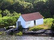
Arrowsic Island is a large island on the Mid Coast of Maine, bounded by a number of tidal rivers. The main one, the Kennebec River, is on the west side of the island, flowing south from the major port and shipbuilding city of Bath to the Gulf of Maine. Squirrel Point is the southwestern tip of the island. The light station at Squirrel Point includes a tower, keeper's house, barn, boathouse, and oil house. The tower is an octagonal wood-frame structure, with the lantern house topped by a ventilator and surrounded by an iron railing and wooden bracketed gallery. A gabled sound signal chamber is attached to one side. The keeper's house is a two-story wood frame structure with a cross-gable roof.[5]
The United States Congress authorized improvements to the aids to navigation on the Kennebec River in 1895, and this station was built under that authorization in 1898. The oil house was added in 1906, and the station was automated in 1982.[5]
Gallery


See also
| Wikimedia Commons has media related to Squirrel Point Light. |
References
- ↑ "Historic Light Station Information and Photography: Maine". United States Coast Guard Historian's Office.
- ↑ Light List, Volume I, Atlantic Coast, St. Croix River, Maine to Shrewsbury River, New Jersey (PDF). Light List. United States Coast Guard. 2009. p. 52.
- ↑ Rowlett, Russ (2009-10-09). "Lighthouses of the United States: Southern Maine". The Lighthouse Directory. University of North Carolina at Chapel Hill.
- 1 2 National Park Service (2009-03-13). "National Register Information System". National Register of Historic Places. National Park Service.
- 1 2 Kirk Mohney (1977). "NRHP nomination for Squirrel Point Light Station". National Park Service. Retrieved 2016-06-17. with photos from 1987
| Topics | |
|---|---|
| Lists by states |
|
| Lists by insular areas | |
| Lists by associated states | |
| Other areas | |
| |