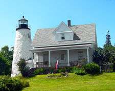
Dice Head Light
 | |
 | |
| Location | Castine, Maine |
|---|---|
| Coordinates | 44°22′57.6″N 68°49′7.86″W / 44.382667°N 68.8188500°WCoordinates: 44°22′57.6″N 68°49′7.86″W / 44.382667°N 68.8188500°W |
| Year first constructed | 1829 |
| Automated | 1937 |
| Deactivated | 1937-2008 |
| Tower shape | Rubble Tower |
| Markings / pattern | White |
| Focal height | 134 feet (41 m) |
| Range | 11 nautical miles (20 km; 13 mi) |
| Characteristic | Fl W 6s |
| Fog signal | none |
| USCG number | |
| Part of | Castine Historic District |
| NRHP reference # | 73000240[3] |
| Added to NRHP | February 23, 1973 |
| Heritage |
place listed on the National Register of Historic Places |
Dice Head Light is a lighthouse in the town of Castine, Maine. First established in 1829, the light was deactivated in 1937 and replaced by a skeleton tower 475 feet (145 m) to the south. When that structure was destroyed by a storm in 2007, however, the old light was reactivated in 2008.[4]
The lighthouse is listed on the National Register of Historic Places as a contributing property to Castine Historic District.[5]
References
- ↑ "Historic Light Station Information and Photography: Maine". United States Coast Guard Historian's Office. 2009-08-06.
- ↑ Light List, Volume I, Atlantic Coast, St. Croix River, Maine to Shrewsbury River, New Jersey (PDF). Light List. United States Coast Guard. 2009. p. 32.
- ↑ National Park Service (2009-03-13). "National Register Information System". National Register of Historic Places. National Park Service.
- ↑ Rowlett, Russ (2009-08-13). "Lighthouses of the United States: Eastern Maine". The Lighthouse Directory. University of North Carolina at Chapel Hill.
- ↑ "Inventory of Historic Light Stations - Maine - Dice Head Light". National Park Service. Retrieved 2009-08-11.
| Wikimedia Commons has media related to Dice Head Light. |
| Topics | |
|---|---|
| Lists by states |
|
| Lists by insular areas | |
| Lists by associated states | |
| Other areas | |
| |
This article is issued from
Wikipedia.
The text is licensed under Creative Commons - Attribution - Sharealike.
Additional terms may apply for the media files.