Avery Rock Light
 | |
 | |
| Location | Avery Rock, Machias Bay, Maine |
|---|---|
| Coordinates | 44°39′16″N 67°20′39″W / 44.65444°N 67.34417°WCoordinates: 44°39′16″N 67°20′39″W / 44.65444°N 67.34417°W |
| Year first constructed | 1875 |
| Year first lit | 1875 |
| Automated | 1926 |
| Deactivated | 1947 |
| Construction | Brick and wood |
| Tower shape | Square tower |
| Height | 34 feet (10 m) |
| Original lens | Fifth order |
| Range | 13 nm |
| Characteristic | Fixed red |
| Fog signal | Bell every 10 seconds |
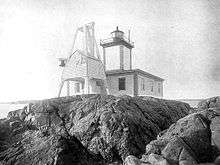
Avery Rock Light was a lighthouse in Avery Rock, Machias Bay, Maine, United States. It was built on a rocky islet, 110 metres long and 48 metres wide, in the middle of Machias Bay accessible only by boat. The old light was a square tower built in 1875 with a gallery and lantern centered on the keeper’s house. The lighthouse was automated in 1926, but it later suffered storm damage in 1947 that was beyond repair which led to its demolition.[1]
The lighthouse was later rebuilt as a 13 feet (4.0 m) skeletal tower with a focal plane at 17 feet (5.2 m) which emits a white flash every 6 seconds.[2]
References
- "Historic Light Station Information and Photography: Maine". United States Coast Guard Historian's Office.
- History of Avery Rock Lighthouse on New England Lighthouses: A Virtual Guide

This article is issued from
Wikipedia.
The text is licensed under Creative Commons - Attribution - Sharealike.
Additional terms may apply for the media files.