Sprucedale, Arizona
| Sprucedale, Arizona | |
|---|---|
| Populated place | |
 Sprucedale Location within the state of Arizona  Sprucedale Sprucedale (the US) | |
| Coordinates: 33°44′25″N 109°19′37″W / 33.74028°N 109.32694°WCoordinates: 33°44′25″N 109°19′37″W / 33.74028°N 109.32694°W | |
| Country | United States |
| State | Arizona |
| County | Greenlee |
| Elevation[1] | 7,549 ft (2,301 m) |
| Time zone | UTC-7 (Mountain (MST)) |
| • Summer (DST) | UTC-7 (MST) |
| Area code(s) | 928 |
| FIPS code | 04-69070 |
| GNIS feature ID | 34753 |
Sprucedale is a populated place situated in Greenlee County, Arizona.[2] It has an estimated elevation of 7,549 feet (2,301 m) above sea level.[1] The location was originally called Espero, for the Spanish word for "hope", and was founded by Hiram and Maryette Thompson, who homesteaded the area after moving from Springerville, Arizona.[3] A U.S. Post Office named Espero existed at the location from 1919 through 1934.[1] The property was purchased in 1921 by E.H. Patterson, and his wife Bertha, who turned the location into guest ranch.[1][3] At some point between 1934 and 1941 the name was changed to Sprucedale. The Pattersons sold the property in 1941 for the sum of $10,000 to Walter and Faye Wiltbank.[3]
In 2011, the area was threatened by the Wallow Fire, which burned 538,049 acres (2,177 km2) of land in Arizona and New Mexico.[4]
References
- 1 2 3 4 "Feature Detail Report for: Sprucedale". Geographic Names Information System. United States Geological Survey.
- ↑ "Sprucedale (in Greenlee County, AZ) Populated Place Profile". AZ Hometown Locator. Retrieved April 18, 2017.
- 1 2 3 "Ranch History: Sprucedale Ranch". Arizona Dude Ranch Association. Retrieved April 18, 2017.
- ↑ Bob Berwyn (June 5, 2011). "Massive Arizona wildlfire closes forests, forces evacuations". summit County Citizen's Voice. Retrieved April 18, 2017.
Municipalities and communities of Greenlee County, Arizona, United States | ||
|---|---|---|
| Towns | 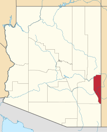 | |
| CDPs | ||
| Populated places | ||