Speke railway station
| Speke Railway Station | |
|---|---|
| Location | |
| Place | Speke |
| Area | Liverpool |
| Coordinates | 53°21′12″N 2°51′07″W / 53.35342°N 2.85181°WCoordinates: 53°21′12″N 2°51′07″W / 53.35342°N 2.85181°W |
| Grid reference | SJ434844 |
| Operations | |
| Original company | St Helens Railway |
| Pre-grouping | LNWR |
| Post-grouping | London Midland and Scottish Railway |
| Platforms | 4[1] |
| History | |
| September 1852 | Opened |
| 22 September 1930 | Closed |
| Disused railway stations in the United Kingdom | |
|
Closed railway stations in Britain A B C D–F G H–J K–L M–O P–R S T–V W–Z | |
|
| |
Speke railway station was located on East side of Woodend Avenue on the southeastern edge of Liverpool, England.
History
The station opened in September 1852 and closed on 22 September 1930.[2]
By 1938 no trace of the platforms could be seen.[3]
| Preceding station | Following station | |||
|---|---|---|---|---|
| Church Road Garston | St Helens Railway | Hale Bank | ||
| Allerton | St Helens Railway | |||
References
- ↑ Gell 1985.
- ↑ The station's history Disused Stations
- ↑ Fields, Gilbert & Knight 1980, Photo 246.
Sources
- Fields, N; Gilbert, A C; Knight, N R (1980), Liverpool to Manchester into the Second Century, Manchester Transport Museum Society, ISBN 978-0-900857-19-5
- Gell, Rob (1985). An Illustrated Survey of Liverpool's Railway Stations 1830-1985. Crosby, Merseyside: Heyday Publishing. ISBN 978-0-947562-03-8.
External links
- The station and local lines on multiple maps Rail Maps Online
- The station on a 25" Edwardian OS Map National Library of Scotland
- The station on line WJL2, with mileages Railway Codes
Closed railway stations in Merseyside | ||
|---|---|---|
| Birkenhead Railway | 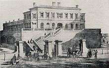 .JPG)   .jpg) | |
| Canada Dock Branch | ||
| Cheshire Lines Committee | ||
| Chester and Birkenhead Railway | ||
| Lancashire Union Railway | ||
| Liverpool and Manchester Railway | ||
| Liverpool, Crosby and Southport Railway | ||
| Liverpool Overhead Railway | ||
| Liverpool, Southport and Preston Junction Railway | ||
| Liverpool, St Helens and South Lancashire Railway | ||
| Manchester and Southport Railway | ||
| Mersey Docks and Harbour Board | ||
| North Mersey Branch | ||
| North Wales and Liverpool Railway | ||
| St Helens and Runcorn Gap Railway | ||
| West Lancashire Railway | ||
| Wirral Railway | ||
| Other | ||
This article is issued from
Wikipedia.
The text is licensed under Creative Commons - Attribution - Sharealike.
Additional terms may apply for the media files.