Runcorn Railway Bridge
| Runcorn Railway Bridge | |
|---|---|
 Runcorn Railway Bridge | |
| Coordinates | 53°20′48″N 2°44′18″W / 53.34676°N 2.73835°WCoordinates: 53°20′48″N 2°44′18″W / 53.34676°N 2.73835°W |
| Carries | Liverpool branch of the West Coast Main Line |
| Crosses |
River Mersey Manchester Ship Canal |
| Locale | Runcorn, Cheshire, England |
| Other name(s) |
Ethelfleda Bridge Queen Ethelfleda Viaduct Britannia Bridge |
| Maintained by | Network Rail |
| Characteristics | |
| Design | double-web lattice girder |
| Material | wrought iron |
| Width | double track |
| Longest span | 305 feet (93 m) |
| Clearance below | 75 feet (23 m) |
| History | |
| Designer | William Baker |
| Opened | 1868 |
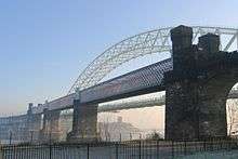
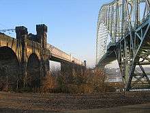
The Runcorn Railway Bridge, Ethelfleda Bridge or Britannia Bridge crosses the River Mersey at Runcorn Gap between Runcorn and Widnes in Cheshire, England. It is situated alongside the Silver Jubilee Bridge. The bridge is recorded in the National Heritage List for England as a Grade II* Listed building.[1]
In 1861, Parliamentary approval for a railway crossing the Mersey was obtained by the London and North Western Railway (LNWR). The design for a bridge and viaducts was produced by William Baker, the company's chief engineer. In 1863, preparatory work for the bridge and approach viaducts commenced. Runcorn Railway Bridge was completed in 1868 and it was opened for traffic on 10 October. The first goods traffic crossed the bridge on 1 February 1869 and the first passenger train on 1 April.
The bridge has received few alterations. In 1965, the pedestrian footway alongside the railway was closed to the public but retained for maintenance access. The bridge is used by rail traffic on the Liverpool branch of the West Coast Main Line. The lines are electrified and 25 kV AC overhead lines installed. Starting in the 2010s, the bridge is undergoing a lengthy maintenance programme that will extend its life for another 150 years.
History
In 1846, the Grand Junction Railway obtained an Act of Parliament authorising the construction of a bridge over the River Mersey at the Runcorn Gap. A time limit of seven years was imposed. The Grand Junction Railway amalgamated with several other companies to form the London and North Western Railway (LNWR). The seven-year time limit passed without construction taking place and the powers granted by the act lapsed.[2] In 1861, the LNWR received Parliamentary approval to build a line crossing the Mersey from Aston southeast of Runcorn, to join the line from Crewe to Warrington at Weaver Junction west of Widnes, where it met the line from Warrington to Garston at Ditton Junction.[3] The line was 8.5 miles (14 km) long and reduced the distance between Liverpool Lime Street and the stations south of the River Weaver by more than 8 miles (13 km).[4] The bridge at Runcorn gap was the responsibility of William Baker, the chief engineer of the LNWR.[5]

During 1863, preparatory work commenced at Runcorn and the first stone was laid in 1864. The bridge's approach viaducts were major structures.[6] By 1868, the bridge was completed and on 21 May the contractor's locomotive Cheshire drew a train of 20 wagons over the bridge.[7] It was opened for traffic on 10 October. The first goods traffic crossed the bridge on 1 February 1869 followed by the first passenger train on 1 April.[5]
During the early 1890s, the Manchester Ship Canal was constructed passing underneath the railway bridge.[8] The footway was closed to pedestrians in 1965 but remains intact for access by railway personnel and carries an 11kV electrical cable between Widnes and Runcorn.[9][6] The bridge remains in use for rail traffic on the Liverpool branch of the West Coast Main Line. The lines on the bridge are electrified with 25 kV AC overhead lines.[6]
An ongoing maintenance programme to address 150 years of wear and tear began in the 2010s.[6] The programme is being carried out in three phases. Phase One involved intrusive surveys, including bores into the main deck, in preparation for the following phases.[6] Phase Two involved mechanical repairs and waterproofing the east and west bottom cords along all three spans. Phase Three will replace the structure's main bearings involving jacking up the span structures.[6]
Structure
The bridge carries a double-tracked railway across the River Mersey; it has been recognised as a Grade II* listed structure. The tracks are laid on a metal deck supported by top and bottom box-girder chords, carried on 8.5 metre-high trusses.[6] The bridge superseded a centuries-old ferry and a pedestrian footbridge set alongside the main girders was provided on its eastern side.[4] On completion, the bridge was the longest of its type.[10] An engraved stone plaque on the northerly portal records that the main contractor was Brassey & Ogilvie and the ironworks were manufactured by Cochrane Grove & Co. Large portions of the original ironworks have been restored or replaced with new castings.[6]
As built, the bridge consisted of three wrought iron spans of 305 feet (93 m), each located on top of two sandstone abutments with foundations at a depth of about 45 feet (14 m) below water level.[6] The trusses support the metal bridge deck, which carries the railway lines. The erection of the lattice girder spans was unusual, because instead of floating the finished sections down the river and lifting them into position, each was built up piece by piece in situ.[6] There are six lattice girders, two for each span. Each girder contains around 700 tons of iron and is fastened by 48,115 rivets. During the first half of the 20th century, some of the wrought iron girders were replaced by steel counterparts.[6]
The bridge has a clearance of 75 feet (23 m) above the high water mark allowing sailing ships to pass beneath. The height was stipulated by the Admiralty which had insisted on a clearance of at least 75 feet.[6] The approaches to the bridge on both sides accommodated its considerable height and a gradient of 1 in 114 was needed to obtain the clearance height of 75 feet above the high-water mark beneath the central spans.[6] On the north side of the river, the bridge is approached by a 49-arch viaduct and a short embankment followed by 16 arches. From the south, it is approached by a 33-arch viaduct.[11] The viaduct piers, bridge abutments and the bridge's central piers are of sandstone and the viaduct arches are of brick.[6]
The bridge has posed challenges in its maintenance; being exposed to high winds, monitoring the prevailing conditions of each day is important.[6] Access to the site is difficult because of the limited space particularly on the narrow walkway, sometimes requiring suspended scaffolding and climbing ropes. More elaborate methods of moving supplies and equipment have included bespoke trolleys and lifting frames and helicopters.[6] Maintenance staff wear harnesses and are tied onto elements of the bridge and on occasion, rescue boats have been kept on standby should personnel fall from the bridge.[6]
From the mid-2010s, extensive repairs and modifications have been carried out.[6] The cantilevered walkway's cast iron parapets were removed and restored, its cantilevered beams and bottom chords were grit-blasted, the end plates were removed and replaced for greater strength. It was painted with two-pack epoxy paint, with a polyurethane top coat coloured to match the rest of the structure.[6] Work was carried on bridge's drains and waterproofing, especially the castellated turrets and the timber fenders that protect the piers from damage. Work on the bridge requires authorisation from Halton Borough Council's planning authority and the Marine Management Organisation because of the potential impact on shipping.[6]
Name

The official name of the bridge has been a subject of debate. Locally, it has been called the Queen Ethelfleda Viaduct,[12] but is also called the Britannia Bridge. It has been claimed that it was named after Ethelfleda, a ruler of the historic Anglo-Saxon kingdom of Mercia, and that the southern abutments and pier of the bridge have been built on the site of the Saxon burh that had been erected by her in 915.[7] This connection is alleged to be the reason why LNWR had opted to have elements of the bridge castellated.[6] There are three shields above the footway showing, from the southern end, the Coat of Arms of the City of London, Britannia (from the crest of the railway company) and the Liver Bird of Liverpool.[9] Because of the presence of the crest, the bridge is also known as the Britannia Railway Bridge.[7]
See also
References
Citations
- ↑ Historic England, "Runcorn Bridge railway bridge over River Mersey (1130418)", National Heritage List for England, retrieved 23 June 2013
- ↑ Cowan 1990, p. 5.
- ↑ Starkey 1990, pp. 168–170.
- 1 2 Holt 1986, p. 65.
- 1 2 Cowan 1990, p. 11.
- 1 2 3 4 5 6 7 8 9 10 11 12 13 14 15 16 17 18 19 20 21 Marsh, Stewart. "Restoration work on the Runcorn railway bridge." Rail Engineer, 27 April 2018.
- 1 2 3 Starkey 1990, p. 170.
- ↑ Starkey 1990, pp. 186–187.
- 1 2 Cowan 1990, p. 17.
- ↑ West Bank Promenade Conservation Area, Halton Borough Council, p. 10, Archived from the original on 28 September 2007, retrieved 14 September 2013
- ↑ Cowan 1990, pp. 5–6.
- ↑ "Lady of the Mercians." cc-publishing.co.uk, Retrieved: 18 May 2018.
Sources
- Cowan, C. A. (1990), Runcorn Railway Bridge, Crossing the Runcorn Gap, 3, Halton: Halton Borough Council
- Holt, Geoffrey O. (1986) [1978], The North West, A Regional History of the Railways of Great Britain, 10 (2nd ed.), David St John Thomas, ISBN 0-946537-34-8
- Starkey, H. F. (1990), Old Runcorn, Halton: Halton Borough Council
Further reading
- Anon (1978), The Bridging of Runcorn Gap, Widnes: Halton Borough Council
- Cowan, C. A. (1990), Runcorn Ferry and Hale Ford, Crossing the Runcorn Gap, 1, Halton: Halton Borough Council
- Cowan, C. A. (1992), Early Bridging Proposals, Crossing the Runcorn Gap, 2, Halton: Halton Borough Council
- Thompson, Dave (2000), Bridging the Mersey: A Pictorial History, Zaltbommel: European Library, ISBN 978-9-028-82640-3
External links
| Wikimedia Commons has media related to Runcorn Railway Bridge. |
| Next crossing upstream | River Mersey | Next crossing downstream |
| Silver Jubilee Bridge | Runcorn Railway Bridge | Mersey Railway Tunnel |