Gerards Bridge railway station
| Gerards Bridge | |
|---|---|
| Location | |
| Place | St Helens |
| Area | St Helens |
| Coordinates | 53°27′45″N 2°43′51″W / 53.462481°N 2.730809°WCoordinates: 53°27′45″N 2°43′51″W / 53.462481°N 2.730809°W |
| Grid reference | SJ516965 |
| Operations | |
| Original company | St Helens Canal and Railway |
| Pre-grouping | London and North Western Railway |
| Platforms | Two |
| History | |
| 1 February 1858 | Opened |
| 1 August 1905 | Closed |
| Disused railway stations in the United Kingdom | |
|
Closed railway stations in Britain A B C D–F G H–J K–L M–O P–R S T–V W–Z | |
|
| |
Gerards Bridge railway station was on the St Helens to Rainford Junction[1] then Ormskirk line immediately north of Haresfinch Road in St Helens, England.[2] It opened on 3 February 1858 and closed on 1 August 1905. Remnants of the line through the station survive, leading to Pilkington's Cowley Hill site, though in September 2015 the tracks were out of use.
Services
The December 1895 timetable showed six "Down" trains to Rainford Junction and five "Up" to St Helens Monday-to-Friday, with an extra train in each direction on Saturdays.No trains called at Gerards Bridge on Sundays.[3]
| Preceding station | Disused railways | Following station | ||
|---|---|---|---|---|
| St Helens Central Line closed, station open |
London and North Western Railway St Helens Canal and Railway |
Moss Bank Line and station closed | ||
References
Sources
- Pixton, Bob (1996), The Archive Photographs Series Widnes and St Helens Railways, The Chalford Publishing Company, ISBN 0 7524 0751 1
External links
- A detailed history via Disused Stations UK
- The station on a 1888-1913 Overlay OS Map via National Library of Scotland
Closed railway stations in Merseyside | ||
|---|---|---|
| Birkenhead Railway | 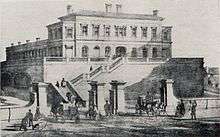 .JPG)   .jpg) | |
| Canada Dock Branch | ||
| Cheshire Lines Committee | ||
| Chester and Birkenhead Railway | ||
| Lancashire Union Railway | ||
| Liverpool and Manchester Railway | ||
| Liverpool, Crosby and Southport Railway | ||
| Liverpool Overhead Railway | ||
| Liverpool, Southport and Preston Junction Railway | ||
| Liverpool, St Helens and South Lancashire Railway | ||
| Manchester and Southport Railway | ||
| Mersey Docks and Harbour Board | ||
| North Mersey Branch | ||
| North Wales and Liverpool Railway | ||
| St Helens and Runcorn Gap Railway | ||
| West Lancashire Railway | ||
| Wirral Railway | ||
| Other | ||
This article is issued from
Wikipedia.
The text is licensed under Creative Commons - Attribution - Sharealike.
Additional terms may apply for the media files.