South Heidelberg Township, Berks County, Pennsylvania
| South Heidelberg Township | |
|---|---|
| Township | |
 | |
 South Heidelberg Township Location of South Heidelberg Township in Pennsylvania  South Heidelberg Township South Heidelberg Township (the US) | |
| Coordinates: 40°18′50″N 76°05′30″W / 40.31389°N 76.09167°WCoordinates: 40°18′50″N 76°05′30″W / 40.31389°N 76.09167°W | |
| Country | United States |
| State | Pennsylvania |
| County | Berks |
| Area[1] | |
| • Total | 13.86 sq mi (35.90 km2) |
| • Land | 13.82 sq mi (35.81 km2) |
| • Water | 0.04 sq mi (0.09 km2) |
| Elevation | 610 ft (190 m) |
| Population (2010) | |
| • Total | 7,271 |
| • Estimate (2016)[2] | 7,352 |
| • Density | 531.79/sq mi (205.33/km2) |
| Time zone | UTC-5 (EST) |
| • Summer (DST) | UTC-4 (EDT) |
| Area code(s) | 610 |
| FIPS code | 42-011-72208 |
South Heidelberg Township is a township in Berks County, Pennsylvania, United States. The population was 7,271 at the 2010 census.
History
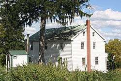
The Grand View Dairy Farm was listed on the National Register of Historic Places in 1992.[3]
Geography
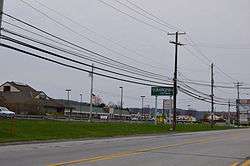
According to the United States Census Bureau, the township has a total area of 13.8 square miles (35.6 km²), all of it land. This once largely rural area is growing fast, with many new residential developments springing up throughout the township, especially near the borough of Wernersville.
Adjacent townships
- Heidelberg Township (northwest)
- Lower Heidelberg Township (north)
- Spring Township (east)
- East Cocalico Township, Lancaster County (far south)
- West Cocalico Township, Lancaster County (south)
The borough of Wernersville is located on the north side of the township, but is politically independent. Also, the borough of Sinking Spring touches the eastern corner of the township.
Demographics
As of the census[4] of 2000, there were 5,491 people, 1,947 households, and 1,516 families residing in the township. The population density was 399.1 people per square mile (154.1/km²). There were 2,027 housing units at an average density of 147.3/sq mi (56.9/km²). The racial makeup of the township was 96.70% White, 1.46% African American, 0.04% Native American, 0.46% Asian, 0.76% from other races, and 0.58% from two or more races. Hispanic or Latino of any race were 1.57% of the population.
| Historical population | |||
|---|---|---|---|
| Census | Pop. | %± | |
| 1980 | 3,355 | — | |
| 1990 | 4,382 | 30.6% | |
| 2000 | 5,491 | 25.3% | |
| 2010 | 7,271 | 32.4% | |
| Est. 2016 | 7,352 | [2] | 1.1% |
| Source: US Census Bureau | |||
There were 1,947 households, out of which 34.7% had children under the age of 18 living with them, 70.6% were married couples living together, 4.8% had a female householder with no husband present, and 22.1% were non-families. 17.7% of all households were made up of individuals, and 6.8% had someone living alone who was 65 years of age or older. The average household size was 2.64 and the average family size was 3.00.
In the township the population was spread out, with 24.2% under the age of 18, 5.1% from 18 to 24, 31.5% from 25 to 44, 27.4% from 45 to 64, and 11.8% who were 65 years of age or older. The median age was 40 years. For every 100 females there were 105.5 males. For every 100 females age 18 and over, there were 102.8 males.
The median income for a household in the township was $57,417, and the median income for a family was $66,618. Males had a median income of $44,471 versus $28,528 for females. The per capita income for the township was $23,266. About 0.5% of families and 6.1% of the population were below the poverty line, including 0.6% of those under age 18 and 3.1% of those age 65 or over.
References
- ↑ "2016 U.S. Gazetteer Files". United States Census Bureau. Retrieved Aug 13, 2017.
- 1 2 "Population and Housing Unit Estimates". Retrieved June 9, 2017.
- ↑ National Park Service (2010-07-09). "National Register Information System". National Register of Historic Places. National Park Service.
- ↑ "American FactFinder". United States Census Bureau. Retrieved 2008-01-31.