Fork, South Carolina
| Fork, South Carolina | |
|---|---|
| Unincorporated community | |
 Fork  Fork | |
| Coordinates: 34°17′18″N 79°16′31″W / 34.28833°N 79.27528°WCoordinates: 34°17′18″N 79°16′31″W / 34.28833°N 79.27528°W | |
| Country | United States |
| State | South Carolina |
| County | Dillon |
| Elevation | 98 ft (30 m) |
| Time zone | UTC-5 (Eastern (EST)) |
| • Summer (DST) | UTC-4 (EDT) |
| ZIP code | 29543 |
| Area code(s) | 843 |
| GNIS feature ID | 1247795[1] |
Fork is an unincorporated community in Dillon County, South Carolina, United States. Fork is located at the junction of South Carolina Highway 41 and South Carolina Highway 57, 10.4 miles (16.7 km) south-southeast of Dillon. Fork has a post office with ZIP code 29543.[2][3]
References
- ↑ "Fork". Geographic Names Information System. United States Geological Survey.
- ↑ United States Postal Service (2012). "USPS - Look Up a ZIP Code". Retrieved 2012-02-15.
- ↑ "Postmaster Finder - Post Offices by ZIP Code". United States Postal Service. Retrieved August 6, 2013.
Municipalities and communities of Dillon County, South Carolina, United States | ||
|---|---|---|
| City | 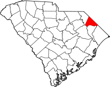 | |
| Towns | ||
| Unincorporated communities | ||
This article is issued from
Wikipedia.
The text is licensed under Creative Commons - Attribution - Sharealike.
Additional terms may apply for the media files.