Westhampton Beach, New York
| Westhampton Beach, New York | |
|---|---|
| Village | |
| Incorporated Village of Westhampton Beach | |
 | |
 | |
 Westhampton Beach | |
| Coordinates: 40°48′32″N 72°38′46″W / 40.80889°N 72.64611°WCoordinates: 40°48′32″N 72°38′46″W / 40.80889°N 72.64611°W | |
| Country | United States |
| State | New York |
| County | Suffolk |
| Area | |
| • Total | 3.0 sq mi (7.7 km2) |
| • Land | 2.9 sq mi (7.5 km2) |
| • Water | 0.1 sq mi (0.2 km2) |
| Elevation | 7 ft (2 m) |
| Population (2010) | |
| • Total | 1,721 |
| • Estimate (2016)[1] | 1,766 |
| • Density | 570/sq mi (220/km2) |
| Time zone | UTC-5 (Eastern (EST)) |
| • Summer (DST) | UTC-4 (EDT) |
| ZIP code | 11978 |
| Area code(s) | 631 |
| FIPS code | 36-80181[2] |
| GNIS feature ID | 0970921[3] |
| Website |
westhamptonbeach |
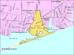
The Incorporated Village of Westhampton Beach is an incorporated village on the southeast coast of Long Island. Administratively it is in the town of Southampton, Suffolk County, New York, United States. As of the 2010 census, the village population was 1,721.[4]
History
The village of Westhampton Beach was incorporated in 1928.[5] In 1938, almost all summer homes on its barrier beach were obliterated by a hurricane resulting in twenty-nine local deaths.
Like most of the shoreline of southern Long Island, the beach at Westhampton Beach was eroding shoreward.[6] This became a political issue in the 1960s. The project to protect the beaches in the area from further erosion was started by the Army Corp of Engineers in 1966, but was only partially completed because of the failure to secure funds from the state and local government. In addition the project design was seriously flawed.[7] As a result, there was increased erosion at the beaches in Westhampton Beach while, up current, the beaches actually grew. During the late 1970s and through the 1980s, beach homes were washed away with every severe storm (nor'easter) that hit the coast. It was only after the nor'easter of November 1992 destroyed over eighty homes, that the Army Corp of Engineers began renewed repair efforts.[7] In the mid-1990s, fifteen historic houses were relocated by the Army Corps of Engineers. The homes were moved off the beach and out of harm's way, at least for a while, but the beach is still eroding and addition damage is incurred with every storm.[7] Additional work was required after Hurricane Sandy in 2012.[8]
.jpg)
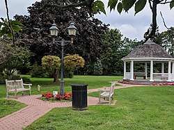
The Crowther House, Foster-Meeker House, and U.S. Post Office are listed on the National Register of Historic Places.[9] Westhampton Beach has its own police and fire departments.[5]
Geography
Westhampton Beach is located at 40°48′32″N 72°38′46″W / 40.80889°N 72.64611°W (40.808995, -72.646009).[10]
According to the United States Census Bureau, the village has a total area of 3.0 square miles (7.8 km2), of which 2.9 square miles (7.5 km2) is land and 0.1 square miles (0.26 km2), or 2.35%, is water.
Demographics
| Historical population | |||
|---|---|---|---|
| Census | Pop. | %± | |
| 1930 | 994 | — | |
| 1940 | 969 | −2.5% | |
| 1950 | 1,087 | 12.2% | |
| 1960 | 1,460 | 34.3% | |
| 1970 | 1,926 | 31.9% | |
| 1980 | 1,629 | −15.4% | |
| 1990 | 1,571 | −3.6% | |
| 2000 | 1,902 | 21.1% | |
| 2010 | 1,721 | −9.5% | |
| Est. 2016 | 1,766 | [1] | 2.6% |
| U.S. Decennial Census[11] | |||
As of the census[2] of 2000, there were 1,902 people, 1805 households, and 498 families residing in the village. The population density was 654.2 people per square mile (252.4/km²). There were 2,279 housing units at an average density of 783.9 per square mile (302.4/km²). The racial makeup of the village was 89.17% White, 4.63% African American, 0.42% Native American, 1.16% Asian, 0.05% Pacific Islander, 2.84% from other races, and 1.74% from two or more races. Hispanic or Latino of any race were 7.68% of the population.

There were 805 households out of which 22.2% had children under the age of 18 living with them, 47.1% were married couples living together, 11.1% had a female householder with no husband present, and 38.1% were non-families. 32.7% of all households were made up of individuals and 13.7% had someone living alone who was 65 years of age or older. The average household size was 2.25 and the average family size was 2.81.
In the village, the population was spread out with 20.5% under the age of 18, 6.1% from 18 to 24, 24.6% from 25 to 44, 28.2% from 45 to 64, and 20.7% who were 65 years of age or older. The median age was 44 years. For every 100 females, there were 93.5 males. For every 100 females age 18 and over, there were 92.2 males.
The median income for a household in the village was $58,438, and the median income for a family was $74,412. Males had a median income of $55,625 versus $33,000 for females. The per capita income for the village was $38,500. About 6.8% of families and 9.0% of the population were below the poverty line, including 10.9% of those under age 18 and 4.3% of those age 65 or over.
Education
- Westhampton Beach Elementary School
- Westhampton Beach Middle School
- Westhampton Beach High School
Transportation
Westhampton Beach and the surrounding area is served by Sunrise Highway (NY 27), which is a major artery to the western parts of Long Island and New York City. The hamlet is also served by Montauk Highway (CR 80), a two-lane road which runs from New York City to Montauk. Montauk Highway serves as the "Main Street" of many towns and villages along the south shore of Long Island.
The Long Island Rail Road provides limited rail service seven days per week via the Montauk Branch connecting Westhampton to Montauk and New York City. Hampton Jitney coach bus service provides slightly more frequent passenger travel between New York City and Westhampton, especially during summer months. Local Suffolk County buses also provide service to neighboring areas.
See also
References
- 1 2 "Population and Housing Unit Estimates". Retrieved June 9, 2017.
- 1 2 "American FactFinder". United States Census Bureau. Retrieved 2008-01-31.
- ↑ "US Board on Geographic Names". United States Geological Survey. 2007-10-25. Retrieved 2008-01-31.
- ↑ "Geographic Identifiers: 2010 Demographic Profile Data (G001): Westhampton Beach village, New York". U.S. Census Bureau, American Factfinder. Retrieved 2012-12-21.
- 1 2 "Westhampton Beach". Your Guide to East Long Island. EastLongIsland.com.
- ↑ Mandia, Scott A. "Geological Impact of the 1938 Hurricane". Archived from the original on 1 January 2016.
- 1 2 3 "The Westhampton Beach Disaster". Geology of National Parks, 3D and Photographic Tours. United States Geological Survey (USGS). Archived from the original on 16 June 2010.
- ↑ "Westhampton Beach Interim Project complete; caps two years' work restoring the New York-New Jersey coastline". U.S. Army Corps of Engineers. 26 February 2015. Archived from the original on 22 November 2016.
- ↑ National Park Service (2010-07-09). "National Register Information System". National Register of Historic Places. National Park Service.
- ↑ "US Gazetteer files: 2010, 2000, and 1990". United States Census Bureau. 2011-02-12. Retrieved 2011-04-23.
- ↑ "Census of Population and Housing". Census.gov. Retrieved June 4, 2015.
External links
| Wikivoyage has a travel guide for Westhampton Beach. |
| Preceded by Quogue |
The Hamptons | Succeeded by West Hampton Dunes |