Sinjar District
| Sinjar District Shingal District | |
|---|---|
| District | |
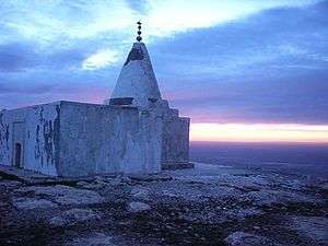 Yezidi Temple on Sinjar, 2004. | |
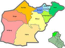 Sinjar district (orange) in Ninawa | |
| Coordinates: 36°19′21″N 41°51′51″E / 36.32250°N 41.86417°ECoordinates: 36°19′21″N 41°51′51″E / 36.32250°N 41.86417°E | |
| Country |
|
| Governorate | Nineveh |
| Royal Decree 4 | 1934 |
| Seat | Shingal |
| Area | |
| • Total | 2,928 km2 (1,131 sq mi) |
| Population (2003) | |
| • Total | 166,466 |
| Time zone | UTC+3 (AST) |
The Sinjar District (Kurdish: Şengal/Şingal/Şingar) is a district of the Nineveh Governorate. The district seat is the town of Shingal. The district has two subdistricts, al-Shemal and al-Qayrawan. The district is one of two major population centers for Yazidis, the other being Shekhan District.[1]
History
Sinjar District was created in 1934 by Royal decree.[2] After the 1935 Yazidi revolt, the district was placed under military control.[3][4]
The al-Shamal district, originally formed in 1936, was abolished in 1987, and its area was added to Sinjar. Qayrawan was formed as a district in 1977, was also abolished in 1987, and was added to the district.[2] In 1994, al-Shamal and Qayrawan were reformed as a sub-districts.[2]
In 2007, several explosions set off by al-Qaeda in Iraq killed hundreds of Yazidis in Shengal.[1]
In August 2014, the Siege of Mount Sinjar raged between Sunni militants of Islamic State of Iraq and the Levant (ISIL) and the Kurdish Peshmerga, leading to a mass exodus of residents, especially from the Yazidi community, branded by the Islamic State as "devil worshipers", after the Peshmerga was defeated.[5] The New York Times reported that ISIL killed dozens of Yazidi men and forced their women to marry jihadi fighters."[6]
A Kurdish Peshmerga-led Sinjar offensive occurred from December 17 to 21, 2014, which included the ending of the siege of Mount Sinjar and freeing the district from ISIL control.
According to Kurdish sources, nine Yazidi mass graves had been found by the end of the offensive. Eighteen Yazidi shrines have also been destroyed by ISIL militants since June 2014.[7] As additional graves were found, masked Yazidis retaliated against assumed ISIL collaborators in four Muslim villages in late January 2015 with Sibaya and Chiri attacked on January 25 and Khazuga and Sayer on January 26. PKK and YPG/YPJ joint forces were able to stop additional attacks on two more villages after Peshmerga fled the area.[8]
It was announced on October 17, 2017 that the area had returned to Iraqi government control.[9]
Geography
The district borders and is a crossing point with Syria.[10] The district is 136 km from Mosul city, the capital of the Nineveh Governorate.[2] The Sinjar Mountains are located in the district.
Economy
The district's economy is primarily based on agriculture with the main crops being barley, figs, wheat, and tobacco. In the villages of Ain al-Ghazal and Hayali exist oil fields, which were closed because of the Iraq war. Natural gas and heavy minerals exist in the Sinjar Mountains.[2]
Settlements
- Ain al-Ghazal, Sunni[8]
- Bahrava, Yezidi
- Bare, Yezidi
- Borek, Yezidi
- Chiri Yezidi [8]
- Dohula, Yezidi
- Duguri, Yezidi
- Gir Azêr, Yezidi
- Gohbal, Yezidi[8]
- Hayali Yezidi [2]
- Khana Sor, Yezidi
- Khazuga, Sunni [8]
- Majnuniyê, Yezidi
- Qayrawan or Qairouan, also called Balij or Bulayj, Sunni
- Sayer, Sunni[8]
- Sîba Şêx Xidir, Yezidi
- Shingal, Yezidi, seat of the district
- Sinone, Sinuni, Yezidi, seat of Al-Shamal subdistrict
- Sibaya, Sunni[8]
- Solagh, Yezidi
- Wardiyê/Zirafki, Yezidi
- Zorava, Yezidi
others:
- Adîke ئادیکە
- Dihil
- Kersêکەرسێ
- Koço
- Rifeyi
- Sinun
- Gura / Isdêra Şimalê
- Telezêr
- Telqeseb
- Qabusî
- Xalabazar
See also
References
- 1 2 Shefler, Gil (August 7, 2014). "Islamic State accused of capturing Yazidi women and forcing them to convert, or else". Washington Post. Religion News Service. Retrieved October 7, 2014.
- 1 2 3 4 5 6 "Report on the Administrative Changes in Kirkuk and the Disputed Regions" (PDF). perleman.org. Kurdistan Regional Government. December 2007. p. 42. Retrieved February 10, 2015.
- ↑ http://www.dtic.mil/cgi-bin/GetTRDoc?AD=ADA405080
- ↑ Fuccaro, Nelinda. Ethnicity, State Formation, and Conscription in Postcolonial Iraq: The Case of the Yazidi Kurds of Jabal Sinjar. International Journal of Middle East Studies Vol. 29, No. 4 (November 1997), pp. 559–580.
- ↑ Loveday Morris (3 August 2014). "Islamic State seizes town of Sinjar, pushing out Kurds and sending Yazidis fleeing". Washington Post. WP website. Retrieved 7 August 2014.
- ↑ Jihadists Rout Kurds in North and Seize Strategic Iraqi Dam. By Tim Arango. August 7, 2014
- ↑ "Nine mass graves of Iraq's Yezidis found in Sinjar, official says". DPA News. Archived from the original on 23 January 2015. Retrieved 30 December 2014.
- 1 2 3 4 5 6 7 Coles, Isabel (February 10, 2015). "Iraqi Yazidis take revenge as Islamic State atrocities unearthed". Reuters. Retrieved February 10, 2015.
- ↑ http://www.kurdistan24.net/en/news/e9d66677-c64c-4151-addb-682bd1006b77
- ↑ A map of its borders is to be found on page 36 of: "Report on the Administrative Changes in Kirkuk and the Disputed Regions" (PDF). perleman.org. Kurdistan Regional Government. December 2007. Retrieved 4 April 2015.