Shoghakat, Armenia
| Shogahakat Շորժա | |
|---|---|
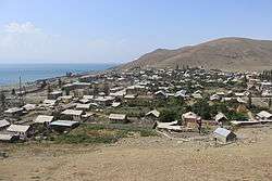 Shoghakat as viewed from atop the adjacent hill with chapel ruins. | |
 Shogahakat Շորժա | |
| Coordinates: 40°30′04″N 45°16′28″E / 40.50111°N 45.27444°ECoordinates: 40°30′04″N 45°16′28″E / 40.50111°N 45.27444°E | |
| Country | Armenia |
| Marz (Province) | Gegharkunik |
| Elevation | 1,915 m (6,283 ft) |
| Population (2011) | |
| • Total | 500 |
| Time zone | UTC+4 (GMT+4) |
| Postal code | 1316 |
Shorgaklat (Armenian: Շողակաթ), known as Shorzha (Armenian: Շորժա) until November 2017 (formerly known as Nadezhdino and Shordzhalu), is a village and a rural community located at Lake Sevan, northwest of the Artanish Peninsula in the Gegharkunik Province of Armenia.
After administrative reforms in November 2017 the name of the village was changed from Shorzha to Shoghakat and it was chosen as administrative center of same-name rural municipality including also villages
Historical sites
There is a 17th-century chapel and cemetery along the southern outskirts of the village. Upon the hill overlooking Shoghakat, there are the ruins of a chapel, and somewhere in the vicinity are the remains of an Iron Age fort.[1]
Nature
Vicinity of the village host 111 species of butterflies and are recognized as Prime Butterfly Area "Artanish-Shoghakat".[2] Also the area is known as one of the Key Birding Sites of Armenia.[3]
Gallery
 Shoghakat Village
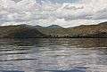 Shoghakat as seen from the Artanish Peninsula
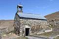 17th-century chapel at the outskirts of the village
 Chapel ruins atop a hill overlooking Shoghakat
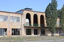 Shoghakat train depot
See also
References
- ↑ Kiesling, Brady; Kojian, Raffi (2005). Rediscovering Armenia: Guide (2nd ed.). Yerevan: Matit Graphic Design Studio. pp. 83–84. ISBN 99941-0-121-8.
- ↑ Prime Butterfly Area "Artanish-Shoghakat". Butterfly Conservation Armenia, 2016. http://www.butterfly-conservation-armenia.org/artanish-shorzha.html
- ↑ Birdwatching. Armenian Bird Census Council. 2016. http://www.abcc-am.org/birdwatching.html
- Shoghakat, Armenia at GEOnet Names Server
- Report of the results of the 2001 Armenian Census, National Statistical Service of the Republic of Armenia
- Brady Kiesling, Rediscovering Armenia, p. 49; original archived at Archive.org, and current version online on Armeniapedia.org.
External links
| Wikimedia Commons has media related to Shorzha. |