Chapkut
| Chapkut Ճապկուտ | |
|---|---|
 Chapkut | |
| Coordinates: 40°39′01″N 45°12′36″E / 40.65028°N 45.21000°ECoordinates: 40°39′01″N 45°12′36″E / 40.65028°N 45.21000°E | |
| Country | Armenia |
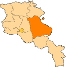
| Marz (Province) | Gegharkunik |
| Elevation | 1,793 m (5,883 ft) |
| Population (2011) | |
| • Total | 0 |
| Time zone | UTC+4 (GMT+4) |
Chapkut (Armenian: Ճապկուտ; formerly known as Jivikhlu), is an abandoned village in the Gegharkunik Province of Armenia. The Azeri population left during the Nagorno-Karabakh War and the area was repopulated by Armenian refugees from Artsvashen. It was included as part of the larger community of Aygut.
See also
References
- Chapkut at GEOnet Names Server
- Report of the results of the 2001 Armenian Census, National Statistical Service of the Republic of Armenia
- Brady Kiesling, Rediscovering Armenia, p. 50; original archived at Archive.org, and current version online on Armeniapedia.org.
This article is issued from
Wikipedia.
The text is licensed under Creative Commons - Attribution - Sharealike.
Additional terms may apply for the media files.