Ayrk
| Ayrk Այրք | |
|---|---|
 | |
 Ayrk Այրք | |
| Coordinates: 40°07′26″N 45°47′26″E / 40.12389°N 45.79056°ECoordinates: 40°07′26″N 45°47′26″E / 40.12389°N 45.79056°E | |
| Country | Armenia |
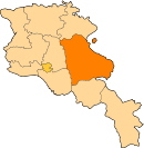
| Marz (Province) | Gegharkunik |
| Elevation | 2,151 m (7,057 ft) |
| Population (2001) | |
| • Total | 441 |
| Time zone | UTC+4 (GMT+4) |
| Postal code | 1605 |
Ayrk (Armenian: Այրք; also Romanized as Ayrk’ and Ayrq; until recently Dashkend and Dashkand) is a small village in the Gegharkunik Province of Armenia. The village has a church of S. Astvatsatsin dated to 1181 and the Katoghike S. Gevorg church nearby (150 meters) dating to the 13th century. Both churches have large graveyards adjoining, and between them are remains of the massive stone walls of an Iron Age fortification with shallow caves below.[1]
Demographics
- Galandar Janbakhishov (born 1957), Doctor of Sciences in Medicine (1999), professor (2010)
See also
References
- Ayrk at GEOnet Names Server
- Report of the results of the 2001 Armenian Census, National Statistical Service of the Republic of Armenia
- Brady Kiesling, Rediscovering Armenia, p. 48; original archived at Archive.org, and current version online on Armeniapedia.org.
This article is issued from
Wikipedia.
The text is licensed under Creative Commons - Attribution - Sharealike.
Additional terms may apply for the media files.