Sharona
| Sharona שרונה | |
|---|---|
.JPG) | |
 Sharona | |
| Coordinates: 32°43′36″N 35°28′0″E / 32.72667°N 35.46667°ECoordinates: 32°43′36″N 35°28′0″E / 32.72667°N 35.46667°E | |
| Grid position | 194/235 PAL |
| District | Northern |
| Council | Lower Galilee |
| Affiliation | Moshavim Movement |
| Founded | 1938 |
| Founded by | Gordonia members |
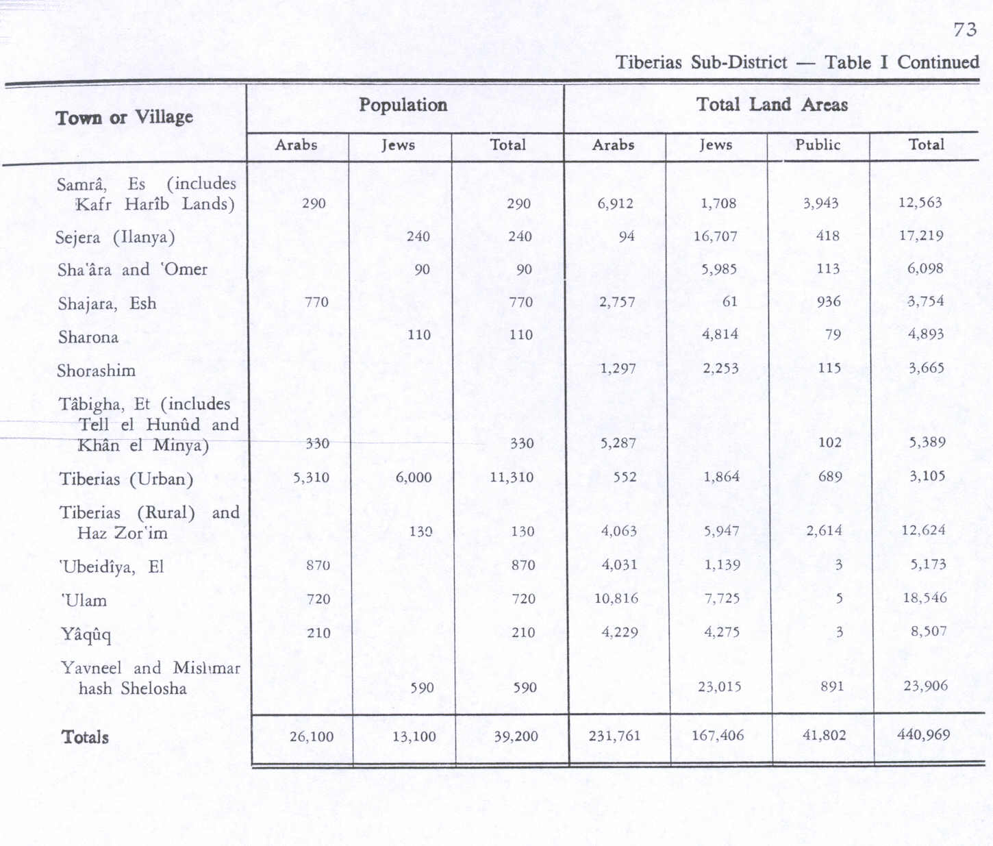
| Population (2017)[1] | 572 |
| Website | www.sarona.co.il |
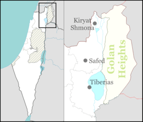
Sharona (Hebrew: שָׁרוֹנָה /saˈʁona/, but publicized in English as /ʃəˈɹoʊnə/[2]) is a moshav in northern Israel. Located south-west of Tiberias, it falls under the jurisdiction of Lower Galilee Regional Council. In 2017 it had a population of 572.[1]
History
In the early 13th century, the geographer Yaqut al-Hamawi described Sârûniyyah as "a pass near Tabariyya, you go up it to reach At Tûr".[3]
Ottoman era
Incorporated into the Ottoman Empire in 1517 with all of Palestine, Sharona appeared under the name of Saruniyya in the 1596 tax registers as being in the nahiya (subdistrict) of Tabariyya under the Liwa of Safad. It had an entirely Muslim population consisting of 17 households. They paid taxes on wheat, barley, occasional revenues, goats and beehives; a total of 3592 Akçe.[4][5]
A map from Napoleon's invasion of 1799 by Pierre Jacotin showed the place, though unnamed.[6]
In 1875, Victor Guérin visited Sarona and noted:
- "This village is divided into two quarters; the houses are rudely built on two hillocks rising round a valley. This is watered from a spring enclosed in a sort of small square chamber, the floor of which is formed of large slabs, and which has a vaulted vestibule built of regular stones."[7]
In 1881, the Palestine Exploration Fund's Survey of Western Palestine noted "basaltic stone houses, containing about 250 Moslems, situated in arable plain, without trees."[8]
According to Avneri, Sarona was settled by Circassian refugees from the Caucasus in 1878, but by 1910 they had moved elsewhere and had been replaced by Arabs.[9] The land was purchased from the Arabs by the Jewish Colonization Association in 1910.[9]
In 1913 a Jewish settlement called Rama, but also called Sarona, was established close to the Arab village by ahuza (estate) members from Chicago.[10] The impact of World War I, poor conditions, and the lack of sufficient manpower kept the new settlement improverished and debt-ridden.[10]
British Mandate era
In the 1922 census of Palestine, conducted by the British Mandate authorities, the new and old settlements together contained 92 inhabitants; 77 Muslims and 15 Jews.[11] In the summer at the end of 1923, additional Jewish settlers, Brisk kevutzah from Kfar Yehezkel, arrived with help from the Jewish National Fund, but by the end of 1928 the settlement had been abandoned and the land returned to the Palestine Jewish Colonization Association, the heir to the Jewish Colonization Association.[10] Half the land was leased to Arab tenants.[12] At the time of the 1931 census the population of Sarona was 114, all Muslims, in a total of 23 houses.[13]
In 1938 a moshav was established by members of the Gordonia organization,[10] with the cost borne by the Palestine Jewish Colonization Association and the Agricultural Workers Federation.[12]
In the 1945 statistics the population was recorded as 110 Jews and no Arabs.[14]
References
- 1 2 "List of localities, in Alphabetical order" (PDF). Israel Central Bureau of Statistics. Retrieved August 26, 2018.
- ↑ "Official Website". Moshav Sharona.
- ↑ Le Strange, 1890, p. 532
- ↑ Hütteroth and Abdulfattah, 1977, p. 187
- ↑ Note that Rhode, 1979, p. 6 writes that the register that Hütteroth and Abdulfattah studied from the Safad-district was not from 1595/6, but from 1548/9
- ↑ Karmon, 1960, p. 167.
- ↑ Guérin, 1880, p. 267 as translated in Conder and Kitchener, 1881, SWP I, p. 361
- ↑ Conder and Kitchener, 1881, SWP I, p. 361
- 1 2 Avneri, 1984, pp. 18, 106
- 1 2 3 4 Glass, 2002, pp. 164-166
- ↑ Barron, 1923, p. 39
- 1 2 Palestine Post, 20 November 1938, p. 2
- ↑ Mills, 1932, p. 84
- ↑ Government of Palestine, Department of Statistics. Village Statistics, April, 1945. Quoted in Hadawi, 1970, p. 73
Bibliography
| Wikimedia Commons has media related to Sharona. |
- Avneri, Arieh L. (1984). The Claim of Dispossession: Jewish Land-settlement and the Arabs, 1878–1948. Transaction Publishers. ISBN 0-87855-964-7.
- Barron, J.B., ed. (1923). Palestine: Report and General Abstracts of the Census of 1922. Government of Palestine.
- Conder, C.R.; Kitchener, H.H. (1881). The Survey of Western Palestine: Memoirs of the Topography, Orography, Hydrography, and Archaeology. 1. London: Committee of the Palestine Exploration Fund. (pp. 370, 379414)
- Glass, Joseph B. (2002). From new Zion to old Zion : American Jewish immigration and settlement in Palestine, 1917 – 1939. Wayne State University Press.
- Guérin, V. (1880). Description Géographique Historique et Archéologique de la Palestine (in French). 3: Galilee, pt. 1. Paris: L'Imprimerie Nationale.
- Hadawi, S. (1970). Village Statistics of 1945: A Classification of Land and Area ownership in Palestine. Palestine Liberation Organization Research Center.
- Hütteroth, Wolf-Dieter; Abdulfattah, Kamal (1977). Historical Geography of Palestine, Transjordan and Southern Syria in the Late 16th Century. Erlanger Geographische Arbeiten, Sonderband 5. Erlangen, Germany: Vorstand der Fränkischen Geographischen Gesellschaft. ISBN 3-920405-41-2.
- Karmon, Y. (1960). "An Analysis of Jacotin's Map of Palestine" (PDF). Israel Exploration Journal. 10 (3, 4): 155–173, 244–253.
- Mills, E., ed. (1932). Census of Palestine 1931. Population of Villages, Towns and Administrative Areas. Jerusalem: Government of Palestine.
- Palmer, E.H. (1881). The Survey of Western Palestine: Arabic and English Name Lists Collected During the Survey by Lieutenants Conder and Kitchener, R. E. Transliterated and Explained by E.H. Palmer. Committee of the Palestine Exploration Fund.
- Rhode, H. (1979). Administration and Population of the Sancak of Safed in the Sixteenth Century. Columbia University.
- Strange, le, G. (1890). Palestine Under the Moslems: A Description of Syria and the Holy Land from A.D. 650 to 1500. Committee of the Palestine Exploration Fund.
External links
- Survey of Western Palestine, Map 6: IAA, Wikimedia commons