Arbel
| Arbel אַרְבֵּל | |
|---|---|
 | |
 Arbel | |
| Coordinates: 32°48′44″N 35°28′57″E / 32.81222°N 35.48250°ECoordinates: 32°48′44″N 35°28′57″E / 32.81222°N 35.48250°E | |
| Grid position | 195/246 PAL |
| Council | Lower Galilee Regional Council |
| Founded | 1949 |
| Founded by | Demobilized soldiers |
| Population (2017)[1] | 732 |
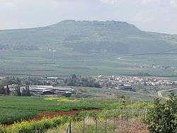
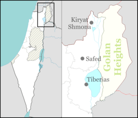
Arbel (Hebrew: אַרְבֵּל) is a moshav in northern Israel. Located on Mount Arbel next to the Sea of Galilee near Tiberias, it falls under the jurisdiction of Lower Galilee Regional Council. In 2017 its population was 732.[1]
Arbel was established in 1949 by demobilized soldiers on the lands of the Palestinian village of Hittin, which became depopulated during the 1948 Arab–Israeli War.[2] It was initially a moshav shitufi, but became a moshav ovdim in 1959.
History
Ceramics from the late Roman and Byzantine periods have been found.[3]
In Second Temple period, the village of Arbel was the home of the sage Nittai of Arbela. According to Josephus, Arbel was the site of military operations carried out by the forces of Herod the Great in his conquest of the land from Antigonus II Mattathias.[4]
In 1047 CE, Nasir Khusraw was on a pilgrimage through Palestine, and noted that he came to the village of Irbil, after leaving Hittin, on his way to Tabariyyah. He further noted that "on the south side of [Irbil] rises a mountain; and on the mountain is an enclosure, which same contains four graves -those of the sons of Yacub (Jacob) - .[..] -who were brothers of Yusuff (Joseph) [..] And going onward I came to a hill, and below the hill a cavern, in which was the tomb of the mother of Moses."[5]
In 1517, the village was incorporated into the Ottoman Empire with the rest of Palestine, and in 1596, Irbid appeared in Ottoman tax registers as being in nahiya (subdistrict) of Tabariyya under the liwa' (district) of Safad. It had a population of 2 households, both Muslims. They paid taxes on wheat, barley, summer crops, cotton, goats and/or beehives, olive oil press and/or a press for grape syrup.[6]
In 1875, the French explorer Victor Guérin visited the ruins,[7] and in 1881, the Palestine Exploration Fund's Survey of Western Palestine found at "Kh. Irbid"[8] "important ruins", with "traces of an Arab village".[9]
By 1948, the land belonged to the Arab village of Hittin, which was depopulated in the 1948 Arab–Israeli War.[2]
Ancient synagogue
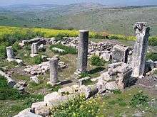
Arbel is notable for the ruins of an ancient synagogue, one of the oldest synagogues in the world, which stands amid the remnants of an ancient Jewish village on the western edge of the moshav. The door of the synagogue, still standing, was carved from a massive natural outcropping of limestone, and the synagogue itself situated so as to make use of the stone as a handsome door. It is carved with decorative floral motifs and medallions. A carved groove for a mezuzah can be seen. Three sides of the building had carved stone benches. The two story building had three rows of columns with Corinthian capitals on the first floor and Ionic capitals on the second floor.[10] It was also a site fortified by Zahir al-Umar.
Notable residents
See also
References
- 1 2 "List of localities, in Alphabetical order" (PDF). Israel Central Bureau of Statistics. Retrieved August 26, 2018.
- 1 2 Khalidi, 1992, p. 523
- ↑ Dauphin, 1998, pp. 718-719
- ↑ Josephus Flavius, translated by G.A Williamson, The Jewish War, Penguin Books Ltd, 1959, p.62 - 63
- ↑ Khusraw, 1897, p.16
- ↑ Hütteroth and Abdulfattah, 1977, p. 190
- ↑ Guérin, 1880, pp. 198-201
- ↑ "The ruin of Irbid", according to Palmer, 1881, p. 128
- ↑ Conder and Kitchener, 1881, SWP I, pp. 396-400
- ↑ Ancient Synagogues in the Land of Israel, Mordechai Aviam, Israel Nature and Parks Authority, 1997, p. 16
Bibliography
| Wikimedia Commons has media related to Arbel (moshav). |
- Conder, C.R.; Kitchener, H.H. (1881). The Survey of Western Palestine: Memoirs of the Topography, Orography, Hydrography, and Archaeology. 1. London: Committee of the Palestine Exploration Fund.
- Dauphin, Claudine (1998). La Palestine byzantine, Peuplement et Populations. BAR International Series 726 (in French). III : Catalogue. Oxford: Archeopress. ISBN 0-860549-05-4.
- Hütteroth, Wolf-Dieter; Abdulfattah, Kamal (1977). Historical Geography of Palestine, Transjordan and Southern Syria in the Late 16th Century. Erlanger Geographische Arbeiten, Sonderband 5. Erlangen, Germany: Vorstand der Fränkischen Geographischen Gesellschaft. ISBN 3-920405-41-2.
- Khalidi, W. (1992). All That Remains: The Palestinian Villages Occupied and Depopulated by Israel in 1948. Washington D.C.: Institute for Palestine Studies. ISBN 0-88728-224-5.
- Nasir-I-Khusrau; et al. (1897). Vol IV. A journey through Syria and Palestine (1047 CE.). The pilgrimage of Saewolf to Jerusalem. The pilgrimage of the Russian abbot Daniel. London: Palestine Pilgrims' Text Society.
- Guérin, V. (1880). Description Géographique Historique et Archéologique de la Palestine. Vol 3, Galilee, pt. 1.
- Palmer, E.H. (1881). The Survey of Western Palestine: Arabic and English Name Lists Collected During the Survey by Lieutenants Conder and Kitchener, R. E. Transliterated and Explained by E.H. Palmer. Committee of the Palestine Exploration Fund.
External links
- Survey of Western Palestine, Map 6: IAA, Wikimedia commons