West Seram Regency
| West Seram Regency Kabupaten Seram Bagian Barat | ||
|---|---|---|
| Regency | ||
| ||
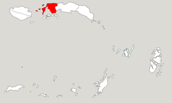 Location within Maluku | ||
| Coordinates: 3°06′10″S 128°25′48″E / 3.1027°S 128.4300°ECoordinates: 3°06′10″S 128°25′48″E / 3.1027°S 128.4300°E | ||
| Country | Indonesia | |
| Province | Maluku | |
| Capital | Piru | |
| Government | ||
| • Regent | Jacobus F. Puttileihalat | |
| • Vice Regent | Timotius Akerina | |
| Area | ||
| • Total | 4,046.35 km2 (1,562.30 sq mi) | |
| Population (2014) | ||
| • Total | 183,412 | |
| • Density | 45/km2 (120/sq mi) | |
| Time zone | UTC+9 (IEST) | |
| Area code | (+62) 911 | |
| Website |
sbbkab | |

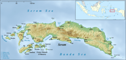

West Seram Regency is a regency of Maluku, Indonesia. It is mainly located on the island of Seram, but includes various small offshore islands. It covers an area of 4,046.35 sq.km, and had a population of 164,654 at the 2010 Census;[1] the latest official estimate (as at January 2014) was 183,412. The principal town lies at Piru.
Administration
At the time of the 2010 Census the regency was divided into four districts (kecamatan), tabulated below with their areas and populations at the 2010 Census.
| Name | Area in sq.km | Population Census 2010 |
|---|---|---|
| Huamual Belakang | 685.8 | 31,499 |
| Seram Barat (West Seram) | 1,108.6 | 61,514 |
| Kairatu | 1,440.1 | 54,135 |
| Taniwel | 1,265.0 | 17,508 |
Subsequent to 2010, seven additional districts have been created by the division of the original four districts, so that the regency is now divided into eleven districts (kecamatan). The seven new districts are:
- Amalatu
- Elpaputih
- Huamual
- Inamosol
- Kairatu Barat (West Kairatu)
- Kepulauan Manipa (Manipa Islands)
- Taniwel Timur (East Taniwel)
References
- ↑ Biro Pusat Statistik, Jakarta, 2011.
External links
| Wikimedia Commons has media related to West Seram Regency. |
This article is issued from
Wikipedia.
The text is licensed under Creative Commons - Attribution - Sharealike.
Additional terms may apply for the media files.