Scott, Quebec
| Scott | |
|---|---|
| Municipality | |
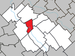
 Location within La Nouvelle-Beauce RCM. | |
 Scott Location in southern Quebec. | |
| Coordinates: 46°30′N 71°04′W / 46.500°N 71.067°WCoordinates: 46°30′N 71°04′W / 46.500°N 71.067°W[1] | |
| Country |
|
| Province |
|
| Region | Chaudière-Appalaches |
| RCM | La Nouvelle-Beauce |
| Constituted | March 29, 1995 |
| Government[2] | |
| • Mayor | Clément Marcoux |
| • Federal riding | Beauce |
| • Prov. riding | Beauce-Nord |
| Area[2][3] | |
| • Total | 32.10 km2 (12.39 sq mi) |
| • Land | 31.33 km2 (12.10 sq mi) |
| Population (2011)[3] | |
| • Total | 2,089 |
| • Density | 66.7/km2 (173/sq mi) |
| • Pop 2006-2011 |
|
| • Dwellings | 929 |
| Time zone | UTC−5 (EST) |
| • Summer (DST) | UTC−4 (EDT) |
| Postal code(s) | G0S 3G0 |
| Area code(s) | 418 and 581 |
| Highways |
|
| Website |
www.municipalite scott.com |
Scott is a municipality in the Municipalité régionale de comté de la Nouvelle-Beauce in Quebec, Canada. It is part of the Chaudière-Appalaches region and the population is 1,812 as of 2009.
Name
Scott can be known under several names, due to a history of name changes, place names, territory breakups, and amalgamations.
- Taschereau-Fortier, religious parish (1824), then territory detached from the parish municipality of Saint-Maxime (1933); it formed the rural part of Scott's territory until 1995. It was named after Gabriel-Elzéar Taschereau and Richard-Achille Fortier, two seigneurs who have had property rights on the territory.
- Saint-Maxime, religious and civil parish (1895), changed name to Scott in 1978. Named after Reverend Maxime Fillion, first priest born on the territory.
- Saint-Maxime-de-Scott, never an official name of the municipality.
- Scott-Jonction, Lévis and Kennebec Railway (1875), then Quebec Central Railway station, located southeast of Saint-Maxime. It is named after Charles Armstrong Scott, who built the first section of the Lévis and Kennebec Railway. Although it was never an official name of the municipality, it has often been referred to as such.
- Scott, named after the train station. Official name of the urban part of the municipality since 1978 and the new territory constituted in 1995 following the amalgamation with Taschereau-Fortier.
References
- Commission de toponymie du Québec
- Ministère des Affaires municipales, des Régions et de l'Occupation du territoire
This article is issued from
Wikipedia.
The text is licensed under Creative Commons - Attribution - Sharealike.
Additional terms may apply for the media files.